- Home
- :
- All Communities
- :
- Developers
- :
- JavaScript Maps SDK
- :
- JavaScript Maps SDK Questions
- :
- Re: Add graphic point after query
- Subscribe to RSS Feed
- Mark Topic as New
- Mark Topic as Read
- Float this Topic for Current User
- Bookmark
- Subscribe
- Mute
- Printer Friendly Page
- Mark as New
- Bookmark
- Subscribe
- Mute
- Subscribe to RSS Feed
- Permalink
I am not sure what I am missing in this code. I am querying a point service and get a result. and then trying to convert the result to graphic to add it on the map... but no luck.
var querystreetIntersect = new Query();
querystreetIntersect.where = where;
querystreetIntersect.returnGeometry = true;
streetLayer.selectFeatures(querystreetIntersect, FeatureLayer.SELECTION_NEW, function (features) {
var lat = features[0].attributes["Lat"];
var lon = features[0].attributes["Long"];
//var point = new Point(lon, lat, new SpatialReference({ wkid: 102100 }));
var simpleMarkerSymbol = new SimpleMarkerSymbol(SimpleMarkerSymbol.STYLE_SQUARE, 12, new SimpleLineSymbol().setStyle(SimpleLineSymbol.STYLE_SOLID).setColor(new Color([100, 100, 100])), new Color([0, 0, 0, 0]));
var graphic = features[0];
graphic.setSymbol(symbol);
console.log(features[0]);
map.graphics.add(graphic);
map.centerAndZoom([lon, lat], 19);
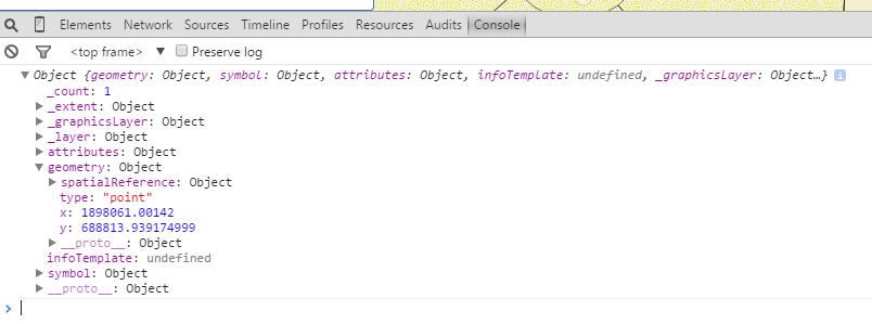
});here is the result object from the console:
Solved! Go to Solution.
Accepted Solutions
- Mark as New
- Bookmark
- Subscribe
- Mute
- Subscribe to RSS Feed
- Permalink
Sorry guys, the problem was my service layer projection system. I had to re-project it in ArcMap in the correct projection and then republished the service.
Now it works just fine.
Thank you all...
- Mark as New
- Bookmark
- Subscribe
- Mute
- Subscribe to RSS Feed
- Permalink
Richard,
It is a bit hard to say without having more code for context. A couple of things I noticed. You are setting the graphic symbol with the symbol variable instead of the simpleMarkerSymbol that you just created. Is that correct?
Is the spatial reference appropriate for the graphic? This may also cause the graphic to not be displayed.
Regards,
Tom
- Mark as New
- Bookmark
- Subscribe
- Mute
- Subscribe to RSS Feed
- Permalink
Thank you Tom for replying. Correct, I changed the "symbol" with "simpleMarkerSymbol" but still nothing. the graphic is not added to the map.
- Mark as New
- Bookmark
- Subscribe
- Mute
- Subscribe to RSS Feed
- Permalink
Richard,
Did you look at the spatial reference? That may be the culprit?
Regards,
Tom Sellsted
Supervising Senior Analyst
[email protected]<mailto:[email protected]>
129 North 2nd Street, Yakima, WA 98901<x-apple-data-detectors://2/1>
Phone (509) 576-6602<tel:(509)%20576-6602> | FAX (509) 249-6835<tel:(509)%20249-6835>
46° 36' 17.86"N 120° 30' 18.23"W
- Mark as New
- Bookmark
- Subscribe
- Mute
- Subscribe to RSS Feed
- Permalink
the spatial reference may be the issue here but I am not quite sure to verify that. I tried graphic.outSpatialReference = { wkid: 102100 };
still nothing. is there another way to convert the spatial reference?
- Mark as New
- Bookmark
- Subscribe
- Mute
- Subscribe to RSS Feed
- Permalink
Richard,
I think somehwere in there you need to create an actual graphic, so you can add it to the graphics layer?
Graphic | API Reference | ArcGIS API for JavaScript
You got your symbol and the geometry, all you need to do is create a graphic from it.
Tim
- Mark as New
- Bookmark
- Subscribe
- Mute
- Subscribe to RSS Feed
- Permalink
Sorry guys, the problem was my service layer projection system. I had to re-project it in ArcMap in the correct projection and then republished the service.
Now it works just fine.
Thank you all...
- Mark as New
- Bookmark
- Subscribe
- Mute
- Subscribe to RSS Feed
- Permalink
Richard,
Glad you got it working!
Regards,
Tom