- Home
- :
- All Communities
- :
- Products
- :
- ArcGIS for Microsoft
- :
- ArcGIS for Microsoft Fabric
- :
- ArcGIS for Power BI
- :
- ArcGIS for Power BI Questions
- :
- US Zip/County/State Maps No Longer Render
- Subscribe to RSS Feed
- Mark Topic as New
- Mark Topic as Read
- Float this Topic for Current User
- Bookmark
- Subscribe
- Mute
- Printer Friendly Page
- Mark as New
- Bookmark
- Subscribe
- Mute
- Subscribe to RSS Feed
- Permalink
Hi. As of Monday Dec 19, none of our previously created maps displaying summarizations by US zip, county and state are rendering. Maps containing points based on Long/Lat are ok.
We have numerous Power BI files, each with multiple report tabs, and the maps throughout all suffer the same problem. I've tried recreating the maps, starting on new report tabs, even starting entirely new files. No luck.
We're using the free Desktop version. No VPN. Occurring from multiple locations. Version: 2.100.684.0 64-bit (December 2021).
Is this a known issue? Or did something change with the free Desktop version? We're a bit stuck at the moment, unable to delivery any of our regular reports/visuals.
Thanks for any thoughts.
Solved! Go to Solution.
Accepted Solutions
- Mark as New
- Bookmark
- Subscribe
- Mute
- Subscribe to RSS Feed
- Permalink
There is a preview feature that is enabled by default in Power BI, that can be disabled, and the boundary matching will continue to work as expected.
https://community.powerbi.com/t5/Desktop/Boundary-matching-no-longer-works-in-ArcGIS/m-p/2275800
This was reported to me on Monday and I've been able to reproduce it myself. A few co-workers have as well, and it appears to be specific to the December update of Power BI. Using earlier releases of Power BI Desktop still work.
As we look deeper into this, we will update everyone with more information.
- Mark as New
- Bookmark
- Subscribe
- Mute
- Subscribe to RSS Feed
- Permalink
Thank you. Is there an easy way to revert from the Dec update to an earlier version? I did a quick search and didn't see anything obvious yet.
- Mark as New
- Bookmark
- Subscribe
- Mute
- Subscribe to RSS Feed
- Permalink
In this post, there is a highlight about each release out each month. Toward the end of that months release/post there is a link to the 32 or 64 bit exe. You can download and re-install Power BI to control which version you're using. https://docs.microsoft.com/en-us/power-bi/fundamentals/desktop-latest-update-archive?tabs=powerbi-de...
- Mark as New
- Bookmark
- Subscribe
- Mute
- Subscribe to RSS Feed
- Permalink
I'm also facing this issue as well and have been for several months now.
Just downloaded the PBI update version: 2.100.1182.0 64-bit (December 2021) to see if it did anything.
Nada (running Arcgis maps v 2021.2.95).
This has been a persistent issue with the "DNA-level" change you had mentioned.
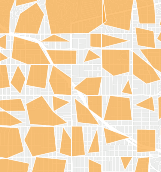
Census tracts rendered poorly, and now they don't show up at all. Zip codes worked, but now they are also not working.
I'm concerned about how things are progressing. Have you been able to identify the issue? Is there a sense of timing?
Appreciate your help and willingness to engage.
- Mark as New
- Bookmark
- Subscribe
- Mute
- Subscribe to RSS Feed
- Permalink
Some progress @Anonymous User
I unchecked all of the Preview Features (I had several enabled), and I was finally able to FINALLY visualize census tracts and zip codes. Not sure what that's about, but wanted to flag that.
However, the maps render poorly as depicted previously and by other users (samples attached).
Any idea why this is happening?
Thanks
- Mark as New
- Bookmark
- Subscribe
- Mute
- Subscribe to RSS Feed
- Permalink
It looks like its calling to a simplified level of geography, instead of the features with higher precision. This is definitively a regression from the previous version, and we can take a look at that for a future update.
At customer request we have been working on ways of providing more control over the geometry and levels of geography. When you have full control of the data engineering in ArcGIS, you can then pull the custom data w/geometry into Power BI. This also helps with embed & P2W scenarios.