- Home
- :
- All Communities
- :
- Products
- :
- ArcGIS for Power BI
- :
- ArcGIS for Power BI Questions
- :
- Lost the visualization of Greece prefectures
- Subscribe to RSS Feed
- Mark Topic as New
- Mark Topic as Read
- Float this Topic for Current User
- Bookmark
- Subscribe
- Mute
- Printer Friendly Page
Lost the visualization of Greece prefectures
- Mark as New
- Bookmark
- Subscribe
- Mute
- Subscribe to RSS Feed
- Permalink
Hello,
After your last update (ArcGIS for Power BI 2024.2.560) we lost the visualization of Greece prefectures.
As Layer Location type I was using a data layer with "Represent location as": Boundaries for "Region": Greece and "Geographic areas": Regions or Decentralized Regions(?).
Now only the "Represent locations as": Points is working OK i.e. by pointing Greece prefectures, but that does not fulfill our requirements.
Could anybody please help?
Solved! Go to Solution.
Accepted Solutions
- Mark as New
- Bookmark
- Subscribe
- Mute
- Subscribe to RSS Feed
- Permalink
Hello @akaradimas ,
After working together with the responsible team, we found that during the Feburary 2025 update, the names for the Subregions where updated as part of a data update by our data provider. Hence, the boundaries were failing to be drawn on the map for Greek prefectures for your dataset.
Please find below a sample dataset that illustrates how the names changed after the data update. Also, attached in a Excel sheet containing the new names that is expected after the data update:
Once again, I apologize for the inconvenience. Please let me know if this resolves your issue.
- Mark as New
- Bookmark
- Subscribe
- Mute
- Subscribe to RSS Feed
- Permalink
Hello @akaradimas,
I just wanted to let you know that we are investigating this issue on our end.
Just to be certain that we are using the same administrative region/boundaries to reproduce, could you confirm if you are having issues with locating boundaries for:
- Greek regions (periféreies) OR
- Greek regional units (perifereiakés enótites)
Also, please kindly provide a sample dataset of the regions that you are trying to locate as boundaries.
- Mark as New
- Bookmark
- Subscribe
- Mute
- Subscribe to RSS Feed
- Permalink
Hello @AlagiriVenkatachal and thank you for your response,
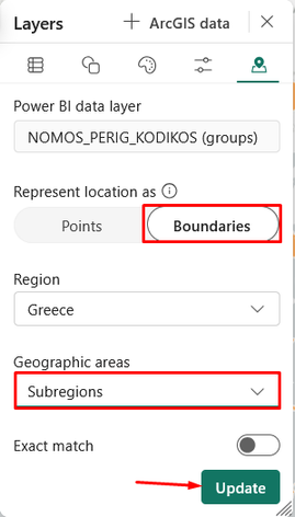
I confirm that after your last update (2024.2.560), Greek "Regional units" (perifereiakes enotites) are not available at the "Geographic areas" drop down list:
When the Greek "Regional units" were available (until end of February 2025), Greece operating map was like the one below:
Could you please bring back the availability of the Greek "Regional units"?
- Mark as New
- Bookmark
- Subscribe
- Mute
- Subscribe to RSS Feed
- Permalink
Hi @akaradimas,
As of the February 2025 update for the Geoenrichment service dataset, the "Regional Units" have been renamed to "Subregions". Please find details on this below in the release notes from the Geoenrichment service data update.
https://doc.arcgis.com/en/esri-demographics/latest/esri-demographics/greece.htm
https://downloads.esri.com/esri_content_doc/dbl/int/GRC_MBR_2024_Release_Notes.pdf
However, there seems to be an issue with looking up the Subregions / prefectures using the most recent data update provided in February 2025. We are working to identify the issue and a potential solution.
Thank you for your patience and understanding.
- Mark as New
- Bookmark
- Subscribe
- Mute
- Subscribe to RSS Feed
- Permalink
Thank you for your effort to provide a solution to our issue.
For your info, I would like to show you how the Greece map is displayed, when I change the "Geographic areas" to "Subregions":
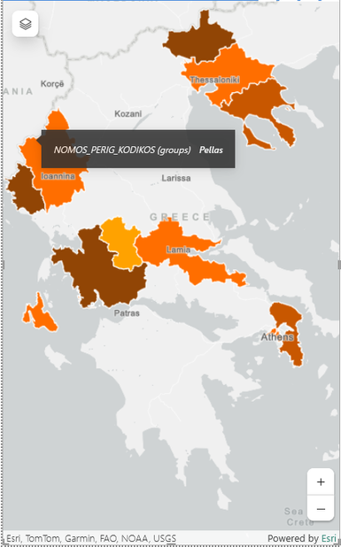
Unfortunately, only 10 (out of 75 in total) "subregions" (perifereiakes enotites) are displayed.
Nine of them show the correct polygon boundaries and only one is displayed as "Pellas" (pls look at the tooltip below) instead of the correct polygon boundaries of "Ioanninon" subregion:
In conclusion, it is certain from the above facts that the "Subregions" are not just the renamed "Regional units".
Data was changed or is now missing from this feature, so we are waiting for your feedback.
Do you think that we should have an applicable solution by the end of next week?
- Mark as New
- Bookmark
- Subscribe
- Mute
- Subscribe to RSS Feed
- Permalink
Hello @akaradimas ,
After working together with the responsible team, we found that during the Feburary 2025 update, the names for the Subregions where updated as part of a data update by our data provider. Hence, the boundaries were failing to be drawn on the map for Greek prefectures for your dataset.
Please find below a sample dataset that illustrates how the names changed after the data update. Also, attached in a Excel sheet containing the new names that is expected after the data update:
Once again, I apologize for the inconvenience. Please let me know if this resolves your issue.
- Mark as New
- Bookmark
- Subscribe
- Mute
- Subscribe to RSS Feed
- Permalink
Hello @AlagiriVenkatachal,
By using your attached Excel sheet I managed to draw on the map all the Greek Subregions (perifereiakes enotites) of our dataset.
Thank you so much for your help. I really appreciate it.
- Mark as New
- Bookmark
- Subscribe
- Mute
- Subscribe to RSS Feed
- Permalink
We have the same issue, but with US Census block groups. It will display points from lat long but not polygon boundaries. It works on the desktop application, but does not work once published to our Power BI report server. I have converted all of our visuals to the Bing map visuals, which doesn't have as many features, but the ArcGIS visual is not stable enough for production applications.
Power BI Report Server Version 1.21.9032.4573 (September 2024)
Power BI Desktop (Optimized for Report Server) Version: 2.136.1202.0 64-bit (September 2024)
ArcGIS for Power BI version 2024.2.560


