- Home
- :
- All Communities
- :
- Products
- :
- ArcGIS Field Maps
- :
- ArcGIS Field Maps Questions
- :
- Re: Collect Orthometric Height in Field Maps and P...
- Subscribe to RSS Feed
- Mark Topic as New
- Mark Topic as Read
- Float this Topic for Current User
- Bookmark
- Subscribe
- Mute
- Printer Friendly Page
Collect Orthometric Height in Field Maps and Projected Coordinate Systems in Field Maps
- Mark as New
- Bookmark
- Subscribe
- Mute
- Subscribe to RSS Feed
- Permalink
Has anyone "cracked the code" on how to get the orthometric height attribute exported from a point feature collected in Field Maps? I have read articles high and low on this subject but cannot figure out a successful way to get this to work. I have seen some post and articles but the solutions are pages long. This should be an easy out of the box solution/option. I am using an external GPS receiver and would like to record Z-values in NAVD1988(ft). I see it records Altitude as ellipsoidal height, but I do not want that, nor can I think of why anyone recording Z-value would want that over orthometric height. Additionally, I cannot get Field Maps to take a coordinate system other than WGS84, which I think would help me in recording orthometric height. I can create another one in my profile within Field Maps, but in order to use the the esri "canned basemaps that you must have your project set-up to WGS84. I have attempted to create my own simple basemap in my desired projection and bring that into Field Maps, but have had no luck, FieldMaps still says the map and profile coordinate system do not match. Basemaps in ArcMap can be projected on the fly, why not in Field Maps? For a new field collection app, Field Maps seems like it is not ready for "Prime Time". I have other issues I could list, but I have found work arounds for those. I would really like to use esri for a field collection app, but may need to go to another companies app. From a user who has been using Trimble TerraSync, Field Maps does not have near the functionality of TerraSync. Granted TerraSync is now a software dinosaur, but has great functions and options for collection.
- Mark as New
- Bookmark
- Subscribe
- Mute
- Subscribe to RSS Feed
- Permalink
To date I have not had this happen yet. But if I do see that behavior. I'll reply back to this thread. 🙂
- Mark as New
- Bookmark
- Subscribe
- Mute
- Subscribe to RSS Feed
- Permalink
Has this functionality been added to Field Maps?
We have the same problem as Danielle at my company. we wanted to know if there is any news
- Mark as New
- Bookmark
- Subscribe
- Mute
- Subscribe to RSS Feed
- Permalink
MGISS have developed a Field Maps plugin to perform these calculations on the fly (for the UK). Until esri develop this functionality plugins like this are your best bet.
- Mark as New
- Bookmark
- Subscribe
- Mute
- Subscribe to RSS Feed
- Permalink
As @ColinLawrence said above, but can you get your Trimble software to pre process before sending to field maps? I use Trimble Catalyst with Trimble mobile manager, which Ive preloaded with the OSGM15 geoid for United Kingdom, so the gnss z is projected to geoid before hitting field maps, and then the projection from ETRF to OSGB for X and Y is performed in field maps.
Can you do the same with your Trimble device?
David
..Maps with no limits..
- Mark as New
- Bookmark
- Subscribe
- Mute
- Subscribe to RSS Feed
- Permalink
Hi David, check out Z-Transform for OSGM15 transformations in the UK. Runs as a live service processing results directly into your Field Maps feature services - https://mgiss.co.uk/z-transform/
- Mark as New
- Bookmark
- Subscribe
- Mute
- Subscribe to RSS Feed
- Permalink
Hey Brandon,
Have you looked into Frontier Precision's online resources?
https://frontierprecision.com/mean-sea-level-with-trimble-receivers-and-collector-for-arcgis/
- Mark as New
- Bookmark
- Subscribe
- Mute
- Subscribe to RSS Feed
- Permalink
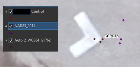
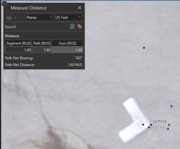
" I cannot get Field Maps to take a coordinate system other than WGS84" I have all ways see this as an issue from the OG Collector app and still in Field Map app. I just got done doing a GPS Accuracy test using R2 with RTX, R1 with SBAS connected to iPhone8+ and Trimble TDC600. I took the steps to save my data projection in NAD832011, set trimble mobile map (TMM) to get the NAD83 output, configured Field Map (FM) with the location profile datum transformation NAD83 to WGS84. All points collected showed a 1.5ft shift when comparing GPS collected point against photo identifiable targets and survey control points. I performed a second round of GPS collection with TMM outputting WGS84 and FM location profile set to default. This setting gave me the results I was looking for. I do not believe any of Esri field mapping applications can WGS84.
- Mark as New
- Bookmark
- Subscribe
- Mute
- Subscribe to RSS Feed
- Permalink
Hi Brandon,
I just found your question that relates to the problem that I am facing with Field Maps (and earlier Collector) in Iceland. We use local CS and every survey point has a slightly different ortho height when measured in Field Maps. I use Emlid RS2 receiver and the native app ReachViewæ from Emlid gives me the correct height when compared to the data from a local National Survey. However, the esri apps sometimes show up to +/- 30cm difference. Our vertical datum was recently updated based on the new geoid but unfortunately I cannot even choose vertical datum in the field maps. Have you already come up with the solution? Cheers.
- Mark as New
- Bookmark
- Subscribe
- Mute
- Subscribe to RSS Feed
- Permalink
Just an update since my last comment under this topic. We have further developed the GNSS measurement workflow using Field Maps and Emlid GNSS and it works quite smooth so far. I haven't looked into the script for many months and it is kind of a success marker regarding the final working solution in our case. We have in total 20-25 devices in operation and the workers are able to measure the utilities without calling for a surveyor. This is a clear time saving step for us in addition to the live monitoring of the GPS points (instead of CSV files).
Emlid integrates perfectly with Field Maps without any additional app required to run with the field maps (like Trimble Mobile Manager in case of Trimble). We then use postprocessing workflow to further process the data and append it to our existing point features in the Arcgis Enterprise.
We created a specific point feature class for GNSS points in the local coordinate system and added the ESRIGNSS_ fields necessary for the high-precision point collection. Out RTK correction service is also in the local coordinate system so there is a match and no issues occur. Then, during the postprocessing, we extract the X and Y from the "@shape" to populate X and Y on the point features. Thus we get the local coordinates and not just Lat/Lon.
The biggest issue we faced was the vertical datum. The Field Maps uses global geoid EGM96 if I remember correctly. It causes issues with Z value because that geoid is coarser than our local one. Field Maps does not have an option to apply custom geoid (which would be extremely useful) so we have to apply it later during postprocessing. Thus instead of extracting the Z value from the geometry (which is a little off because of the geoid) we use a raw ESRIGNSS_ALTITUDE value to read the ellipsoidal height and then correct with the geoid value from the local geoid DEM for the given location of the point.
The end user only sees the project number and description fields in the field map form and the rest is done in the backend.
In general, the Field Maps is a field data collection and is a perfect solution for different data collection cases. But it is not the surveying app so the limited capabilities in terms of the settings for GNSS measurements is understandable. But in my opinion, if it offers the high-precision data collection, it should also have the option to adjust basic GNSS survey-related things.
- « Previous
-
- 1
- 2
- Next »
- « Previous
-
- 1
- 2
- Next »