- Home
- :
- All Communities
- :
- Products
- :
- ArcGIS Field Maps
- :
- ArcGIS Field Maps Questions
- :
- Re: Avoiding repeating form entries for multiple p...
- Subscribe to RSS Feed
- Mark Topic as New
- Mark Topic as Read
- Float this Topic for Current User
- Bookmark
- Subscribe
- Mute
- Printer Friendly Page
Avoiding repeating form entries for multiple points.
- Mark as New
- Bookmark
- Subscribe
- Mute
- Subscribe to RSS Feed
- Permalink
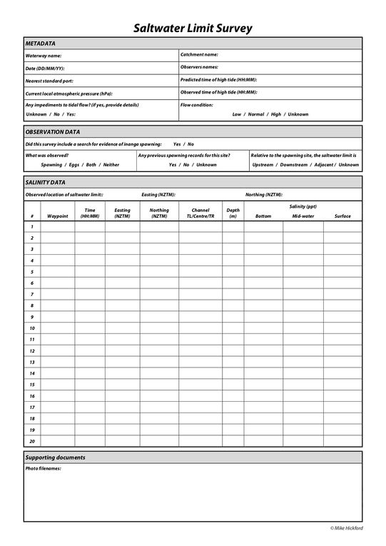
I would like to recreate this paper form in Field Maps (minus any 'location' easting/northing questions).
Each entry of the 'SALINITY DATA' section will be a separate point on the map.
How can I make it that the 'METADATA' and 'OBSERVATION DATA' sections are completed only once by the surveyor, rather than every time a new 'SALINITY DATA' point is created?
- Mark as New
- Bookmark
- Subscribe
- Mute
- Subscribe to RSS Feed
- Permalink
You can place the salinity data in a repeat, that way you can supply multiple answers for the same question. Just add another geopoint question within the repeat to include geometry.
- Mark as New
- Bookmark
- Subscribe
- Mute
- Subscribe to RSS Feed
- Permalink
Thank you.I have used Survey123 in the past for this kind of thing. I was hoping there might be a way I can do it in Field Maps as well.
- Mark as New
- Bookmark
- Subscribe
- Mute
- Subscribe to RSS Feed
- Permalink
Hi @kawakawa4 ,
You may want to explore on creating relationship class for your datasets.
Similar example that you can refer to. Inspect hydrants | Learn ArcGIS
Cheers,
Tang
Tang
- Mark as New
- Bookmark
- Subscribe
- Mute
- Subscribe to RSS Feed
- Permalink
Hi @SzuNyiapTang ,
Thank you for the suggestion. I want to do it slightly differently to that example, but can't work out how to do it:
I want the 'Metadata' section to be a non-spatial table, which is filled out first in Field Maps, then the user will add 'salinity data' points, which will be related to the 'metadata' table. Is this possible in Field Maps, or does the 'metadata' dataset need to be a spatial dataset? I have tried adding a hosted table to my web map but it does not appear in the content of the smart form.
I could create a point layer for the 'metadata', then relate that to the 'salinity data' points, but would like to avoid a spatial dataset for 'metadata' if possible.
- Mark as New
- Bookmark
- Subscribe
- Mute
- Subscribe to RSS Feed
- Permalink
Hi @kawakawa4
Yeah. Will need a spatial data for this approach to work in Field Maps. As you will need to click on a feature to retrieve the metadata and subsequently add salinity point.
It can a polygon ( to represent the project area/coverage). Then salinity points are those different readings.
Tang
- Mark as New
- Bookmark
- Subscribe
- Mute
- Subscribe to RSS Feed
- Permalink
@SzuNyiapTang I have set this up now. I would like my metadata (parent) data points to be edited differently to the related salinity points, i.e. the field worker should not be able to delete or add metadata points, only edit attributes, but have full editing types for the related salinity points. Is this possible?
I tried creating a view of either layer but this breaks the relationship.
- Mark as New
- Bookmark
- Subscribe
- Mute
- Subscribe to RSS Feed
- Permalink
Hi @kawakawa4
It does not have that level of detail of access. The most you can do is to prevent the editors moving the parent layer in which you can disable geometry updates on the parent layer.
Tang

