- Home
- :
- All Communities
- :
- Products
- :
- ArcGIS Field Maps
- :
- ArcGIS Field Maps Ideas
- :
- Add Bearing to Measure Tool in Field Maps
- Subscribe to RSS Feed
- Mark as New
- Mark as Read
- Bookmark
- Follow this Idea
- Printer Friendly Page
- Mark as New
- Bookmark
- Subscribe
- Mute
- Subscribe to RSS Feed
- Permalink
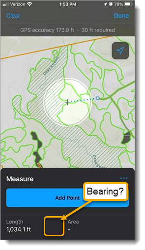
Please add bearing (in numeric degrees) to the Measure tool in Field Maps (see attached picture). If you are on-site with a map in Field Maps you can drop a pin to see your distance and direction (bearing) to a destination; however, you cannot use the measure tool to get the bearing from the origin to destination. Knowing the bearing allows you to dial it in on the azimuth ring of a mapping compass (with declination set to account for the difference between magnetic and true north for your location) for field navigation.
When working with others that don't have Field Maps and you want to provide specific instructions for finding a location (based on the attached picture), you could say something like, "From the end of the spur road, dial in 265 degrees and walk about 15.5 chains (roughly the 1,034 ft as shown) to find the edge of the wetland. There is an eagle's nest in the 36 inch (diameter at breast height (DBA)) white pine." This is just one example, but being able to note the bearing and distance between two features in the field (without having to be there in person), could save a lot of time and effort in communicating directions to others.
- « Previous
-
- 1
- 2
- Next »
The long press is not very useful for navigation. Ideally you input the bearing and distance first, then it will provide the path to the location of interest. With the long press action, you're eyeballing and randomly placing a point and guessing the path, versus knowing the actual bearing (for example, from a survey), typing them in and the tool actually create the linear path of that bearing. Similar to when you draw parcels on AutoCAD and you type in the N01°01'01"E 100.01' bearings.
I guess it depends whether you have locations on the map where you can set the bearing between two points. If I am heading to a campsite from a launch in a boat I can find the bearing on Field Maps. What are the steps for typing in a path?
Agreed--we ask our field staff to measure distance and bearing between a static location and a recorded feature, and one of our top complaints is how difficult it is to measure bearing without this as a default feature.
I think it would also be beneficial to show the distance between the points in a line before you have to place the line.
You must be a registered user to add a comment. If you've already registered, sign in. Otherwise, register and sign in.