ArcGIS Explorer Blog - Page 2

cancel
Showing results for 
Show  only  | Search instead for 
Did you mean: 

Latest Activity

(19 Posts)
ScottB
by Esri Regular Contributor
Esri Regular Contributor

New versions of Explorer for ArcGIS are here for Android (18.1) and iOS (18.1.1), bringing offline maps and feature parity on both platforms.

What’s New with Explorer on Android?

Explorer for ArcGIS 18.1.0 on Android modernizes the app and aligns it with the app currently available on iOS. With this release, the following functionality is brought to Android devices:

Work offline

You can’t be connected everywhere you want to explore, so now you can take your maps offline with you. Prepare a map for offline use in your office and put it on your device, either by downloading it through the app or by sideloading it onto your device. Once it’s on your device, you can work with it in the same way as any other map in Explorer. For details on making offline maps, see Make offline maps.

Note:

With this release, Android supports working offline with vector data as well as imagery and other raster data. The capabilities are the same as those on iOS.

Use improved markup and share it

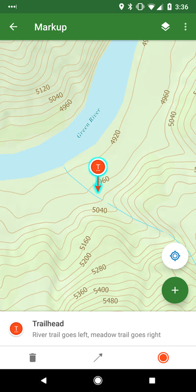
Capture sketches and notes on the map with improved tools. You can clean up as you go, making your sketch a true circle and your line straight. Place markers, draw arrows, and add notes and labels. You can use your sketches across your maps, and even share them as layers to your organization. Mobile workers in the field and ArcGIS Pro users in the office can see and act on what you’ve found. For more information, see Markup.

Find your features with the compass

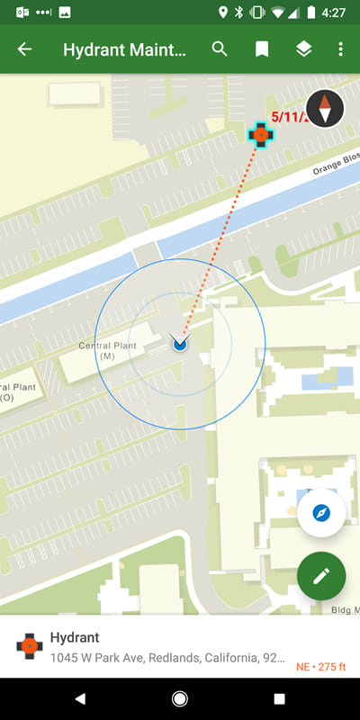
Walk right to your assets using the new compass tool. See how far you are from your assets and which direction you need to go. From a feature, search result, or pin, select Compass . This complements the directions that are available through integration with Navigator for ArcGIS and Google Maps.

Experience a new, simplified browsing experience

Discover maps with ease through a new, simplified browsing experience.

Note:

You can still search for, browse to, and open groups—we learned from our iOS release.

Use beautiful, more responsive and informative maps

Explorer for ArcGIS 17.1.0 includes support for related records, labeling, smart mapping, and vector tile basemaps.

The Explorer team is excited to bring one of the most requested features to life with this update: related records. You can now bring more data to your users by creating pop-ups with related records in your map, and you’ll see the same pop-ups in Explorer.

Another common request has been support for labels, and with this release they are supported. You can even use Arcade expressions to make the best labels for your map.

ArcGIS provides smart mapping to help you make your maps beautiful, while showcasing your data’s important values. Explorer now honors the styling done through smart mapping, bringing the maps you are making in Map Viewer to your devices. Improve your maps with smart mapping: get started with the How to smart map story map.

One of the benefits of working on a mobile device is the high-resolution display, but not all basemaps take full advantage of it. With this release, Explorer supports vector tile basemaps to bring crisp, responsive basemaps to your device. Vector tiles have a combination of tile access performance and vector drawing, allowing the tiles to adapt to any resolution of the display, which may vary across devices. See Vector tile layers (ArcGIS Online or ArcGIS Enterprise) to learn more.

Interact with UX customized for your device

Explorer now makes the best use of available screen space. When working on a phone, the panel resizes to fit your needs. If you need to see mostly the map, collapse the panel into a summary. When you need both the map and details, use the panel in half the screen. When you want to focus on the details, make the panel full-screen. If you are using a tablet, the panel is fixed to the side of the screen.

What’s New with Explorer on iOS?

Take your imagery and other raster data offline

You can now bring your raster data offline with you by including tile packages in your mobile map packages.

Using ArcGIS Pro 2.1 or later, create a mobile map package (MMPK) that contains tile packages (TPKs) of your raster data.

You can use the ‘Share Package’ tool in ArcGIS Pro to choose who can see the package and then upload the MMPK to your ArcGIS Online or ArcGIS Enterprise organization (or, if you prefer, you can sideload the file onto your device directly).

Once your mobile map package is in ArcGIS, users with permission to see the package can sign in to Explorer and download it to their device.

Various bug fixes and improvements

In addition to the functionality described above, there have been other enhancements made and issues addressed. Of note are the following changes:

Updated translations have been added.

Pan and zoom updates: pan and zoom are now supported when a tool panel (such as bookmarks) displays, and What’s Here results pan and zoom the same as other results.

Selecting a search suggestion during dictation no longer crashes the app.

Differences between iOS and Android

While the majority of the functionality is the same, be aware of the following differences:

Sharing a map by URL through the app is only supported on iOS.

Zoom to a feature is only supported on iOS.

Later releases will synchronize these across the platforms.

How do I get Explorer for ArcGIS?

Download Explorer for ArcGIS for your mobile device on the Google Play Store or the Apple App Store today!

We’d love to hear what you think of the new releases. If you want to learn even more, we also have a great documentation site you should check out.


Happy mapping!

Scott and the entire Explorer team

more
1 21 3,939
by Anonymous User
Not applicable

Offline Map Support (MMPK)


Is there support for TPKs? 

A: Yes, TPK support in Mobile Map Packages is coming in 18.1.1 for iOS and 18.1.0 for Android. 


Does Explorer support vector tiles?

A: Yes it does.


Are labels supported in MMPKs in Explorer?

A: Yes, labels are supported depending on how you author your MMPK. 


Is label conflict detection supported?

A: Yes it is, and we are working to further improve the label conflict detection. 


Can the MMPK creation process be scripted? 

A: Yes it can, using Geoprocessing Tools.


When an MMPK is updated, does Explorer download only the changes or the entire map package? 

A: Currently Explorer will download the entire MMPK when there are updates available. We are working on a solution for downloading only the changes for a future release of Explorer. 


Map Markup


Can you add markup labels and have them be displayed on the map? 

A: Currently markup labels can be viewed by selecting a markup element. We're working on a solution where these labels could be displayed on the map. 


Is markup associated with the map that its drawn in? 

A: No, markup isn't associated with the map you were viewing when you made it, it is associated with the app. You can use more than one markup layer to manage the display of markup across multiple maps.


Does markup work when I'm offline? 

A: Yes it does, you can add and edit markup in both online and offline environments. With that being said, you do need to be online to share markup with your ArcGIS organization. 


Is markup a new item type or is it stored as a feature in a feature service?

A: Markup is a new type of item.


Does sharing markup share all markup seen in the view or in the entire map?

A: It depends on how you share the markup. If sharing an image of it, it is a screen capture and just shows what is on your screen (in the extent and visible on the map). Sharing the markup directly with another user or with your ArcGIS organization shares a layer of markup. Each layer of markup you choose to share is shared in full, including the geometry, symbology, label, and any notes for each feature in your markup (independent of what is currently on-screen for the layer).


Other


If a user clicks a URL scheme link and doesn't have Explorer installed what happens?

A: In iOS the URL scheme link would be disabled (not clickable) if Explorer wasn't on the device. Android will return a 'Cannot find an openable app' message.


Can you launch other apps from Explorer?

A: Yes, you can add URLs to popups to launch other apps such as Collector, Navigator or Survey 123.


Can you configure popups to pass attributes?

A: Yes, using the URL scheme.


Can you download multiple offline areas from a single webmap?

A: Soon in the 18.2 release of Explorer you will be able to take parts of a webmap offline and you can take as many area off line as you want from a single webmap. 


Is the size of the download shown before taking an area offline? 

A: Not currently, but we are working to provide an estimate of the offline area download size. 


Is Google authentication supported on Android? 

A: Yes, Google + authentication will be supported in the 18.1.0 release.


Any plans for Explorer on Windows?

A: Currently we do not have plans to build Explorer on the Windows 10 platform. We are continually evaluating platforms demand for our apps. See this Esri blog post for additional information. https://blogs.esri.com/esri/arcgis/2017/04/26/arcgis-apps-for-the-field-on-the-windows-platform/

more
0 4 1,009
Kylie
by Esri Regular Contributor
Esri Regular Contributor

We often get asked for details on creating offline maps for use in Explorer for ArcGIS. Mark Bockenhauer‌ has put together a great two-part blog that goes through each step: from downloading a dataset to working offline in Explorer.

Part 1 includes:

  • An introduction to the ArcGIS Pro project (available for download) that you'll make into an offline map. 
  • Creating a vector tile basemap (VTPK) that your offline map will use as the basemap.
  • Setting up your VTPK as the basemap of your offline map.
  • Including search and bookmarks.

Part 2 continues with:

  • Customizing the information shown for your feature's pop-ups.
  • Creating a mobile map package (MMPK) - which includes your VTPK - and that can be download in Explorer.
  • Sharing the MMPK
  • Trying out your map offline in Explorer.

I'd like to bring this content into the official Explorer help, so if you have feedback, that will help with the next steps for this content. Did his blog help you make your first MMPK? What could be more clear? Where did you get stuck, or was there something that you really loved or appreciated in it?

more
2 35 8,499
ChrisLeSueur
Esri Contributor

We have a new Beta of Explorer for ArcGIS for Android devices (phones and tablet) available through the Google Play Store.  If you would like to participate in testing the latest beta version of Explorer please follow this link for for sign-up instructions.

 Android Explorer Beta: Signup and Install Info

The new Beta 2 release includes the following:

  • Tap features and see details about them, including attachments.
  • View the layers and sublayers in your map and toggle their visibility.
  • Change the basemap.
  • Launch Explorer through an email, a website, or even another app using the custom URL scheme.
  • Sideload mobile map packages (MMPKs) from a central location on the device (/ArcGIS/mmpks), allowing cross-app sharing.
  • Custom attribute display in a feature popup is now supported and rendered in Explorer

We are getting close to the final version of Explorer ver 17.x. Thank you for your continued support of Explorer for ArcGIS. We value your feedback. If you are looking for the iOS version of Explorer please see this blog post: Now Available Explorer for ArcGIS 17.2 Beta 2 for iOS

-Explorer Team

more
2 1 1,332
ChrisLeSueur
Esri Contributor

We have just released a new Beta of Explorer for ArcGIS for iOS devices (iPhones and iPads) through Apple’s TestFlight app.  If you would like to participate in testing the latest beta version of Explorer please send a request to explorer4arcgis@esri.com .

The 17.2 Beta 2 release includes additional functionality based on user feedback as well as important fixes.

Added Functionality:

  • Groups are available in Browse view (BUG-000106841) to provide quick and easy access to the maps organized within Groups in the ArcGIS Organization. You can now search for, browse to, and open the Groups from the browse map experience. 
  • Support for zoom to layer. Tap on a layer name in the map layer list to zoom to the full extent of that layer
  • Addition of magnifier tool BUG-000106840. Access a magnifier window view by a long press and hold on a map display, and then release your finger to drop a pin at that location.

Bug fixes and usability enhancements

  • Updated Measure Tool readability
  • Date filter now being honored
  • Now showing description in Custom Attribute Display instead of domain code
  • Optimized viewing details by auto-selecting features on search and identify if only one result
  • Fixed cases where symbology is not shown in panel
  • Improved identify performance
  • Fixed bug with identifying on layers with in-memory joins


Thank you for your continued support of Explorer for ArcGIS. We value your feedback. If you are looking for the Android version of Explorer please sign up by visiting this link. Contact us at explorer4arcgis@esri.com


-Explorer Team

more
1 1 1,119
JeffShaner
Esri Regular Contributor

Building upon the 17.1.0 and 17.1.1 releases, today we have updated Explorer for ArcGIS in the Apple App Store with some very important fixes:

  • BUG-000106480—Pop-ups are not consistently displaying values when the field alias is different from the field name.
  • BUG-000106814—Configuring custom attribute display to show multiple fields returns nothing.
  • BUG-000107080—Attachments don't display for map service layers.
  • Feature search can fail when searching integer fields using the Equals condition.
  • If the request for an OAUTH page fails when signing in, a message shows instead of a white screen.

We are already planning our next update and it will be coming very soon. A couple of important issues on our pending list include:

  • BUG-000106721—Adding shapefiles enabled for but not containing any z-values into a map stops the map from loading. The error message displayed is *The shape must have a Z value.
  • Performance improvements to the way Explorer performs queries against feature and map services.

Thank you for your continued support.

Explorer Team

more
0 2 1,016
JeffShaner
Esri Regular Contributor

Keeping track of mobile devices with access to your corporate network, maps and data is more important than ever. Organizations are implementing an Enterprise Mobility Management (EMM) solution that provides for management of devices, provisioning of mobile applications, and compliance with corporate policies, and authentication with proper network access control.


There are a number of Mobile Device Management (MDM) products that help you implement your EMM solution and they all include support for Mobile Application Management (MAM). Here are just a few that Esri Apps have been deployed with – MobileIron, AirWatch, XenMobile, MaaS360, Meraki, InTune.


Esri Apps and MDM Products

MDM products can connect directly to the Apple App Store or Google Play and you can manage and deploy applications to your mobile workforce. Esri apps like Explorer, Collector, Navigator and Workforce support per-app VPN so that you can secure device access to internal resources and reduce the inbound connection to a single app at the same time. When considering how you deploy Esri Apps through your MDM, please note that App wrapping is not supported.


Field Apps and Managed App Configuration

Talking with several customers deploying Esri Apps using an MDM, we are following the guidelines found within the AppConfig community.  Explorer, Collector, and Workforce on the iOS and Android platforms have started including settings that take advantage Managed App Configuration API's for each platform. Implementing the MobileAppConfig on iOS and the Backend Service Configuration on Android, you can now streamline app deployment be allowing your MDM to push down the URL of your ArcGIS Enterprise portal.


Implementing the portalURL key that is of Data Type: String, apps will bypass the Portal URL sign in screen and automatically present the OAuth screen from your portal, easing the sign in process for your field workforce.


With Mobile Iron, the following steps can be used to push the Portal URL (using Explorer for ArcGIS on the iOS platform as the example):

  1. In the Core Admin Portal, go to Policies & Configs and navigate through Configurations > Add New > iOS and OS X > Managed App Config.
  2. Edit the Managed App Configuration with the Name, Description, BundleID and select the external file (PLIST), that contains the App-specific key-value pair configurations required for the app.
    Note: You can find the bundle ID for iOS apps by going to Apps > App Catalog, and clicking the hyperlink to edit the app. The bundle ID resides in the inventory field in parenthesis.
  3. To create the PLIST file, create a text file with the following text (see picture below). Replace the value in the portalURL key (<string>value</string>) with your organizations portal url. Save this file as a “.plist file (ie explorerAppConfig.plist).

Mobile Iron PLIST

Here is how it works with Cisco Meraki, the following steps can be used to push the Portal URL:

  1. On Systems Manager, go to Apps > Add New > iOS app > Add App (Enter “Explorer for ArcGIS”) > Add.
  2. Within the Systems Manager, go to Settings > Add > 
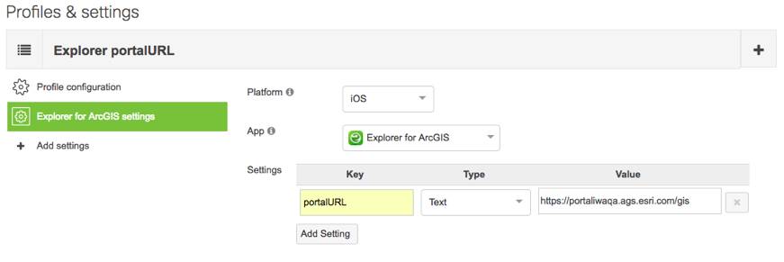
New Meraki managed profile > Create New Profile > Add settings > Choose an app / Settings (see picture below) > Add Setting.

Meraki Config

If you are using another MDM product, please search their documentation for Managed App Config to find the necessary steps.

Moving forward, we are looking to expose more capabilities that follow the guidelines outlined by the AppConfig.org community. 

For more information about Esri's approach to Mobile Application Management, please read our patterns document on the ArcGIS Trust website.  

more
4 12 6,809
JeffShaner
Esri Regular Contributor

After receiving considerable feedback from the 17.1.0 release, we have updated Explorer for ArcGIS on the iOS platform with a strategic bug fix update. Thank you very much for all that have participated in the Test Flight beta for this update. You can now install the final, released version directly from the Apple App Store.

This update includes the following:

  • BUG-000106474—Can't see sublayers in the Layers list, or toggle sublayer visibility.
  • BUG-000106478, BUG-000106507—Hyperlinks appear as text and URLs aren't clickable in the pop-up.
  • BUG-000106475—Feature search fails when searching sublayers.
  • BUG-000106698—Map search settings aren't honored, including disabling search in the app if Find Locations is disabled in the map.
  • Improved performance when searching, identifying, and dropping pins on the map.
  • Search results should list features before places.
  • Improve sorting of maps in the Maps browse screen: sorting by title shouldn't be case sensitive, sorting by date shouldn't put oldest maps first.
  • IWA Portals aren't being remembered in the list of recent portals.
  • Support deep linking to Box with box:// and boxapp:// schemas.

We have started work on the 17.1.2 release as well, with intention to bring a number of additional fixes and strategic updates very soon. The current proposed list of updates includes the following:

  • BUG-000106480—Pop-ups for map services are not consistently displaying values when the field alias is different from the field name. 
    Note: We tried to get a fix for this into 17.1.1, but could only get a partial fix for map services hosted on ArcGIS Server 10.5 or later, and we didn't have a fix for earlier versions of ArcGIS Server. We have decided to wait and make sure we fix this properly, which unfortunately will take a bit longer. In the meantime, you can try one of the following workarounds:
  • BUG-000106721—Maps with uploaded shapefiles that contain a z-value don't load
  • Correctly format dates and coded value domains in pop-ups when the field name and alias don't match.
  • Certain layers not displaying and instead showing an exclamation mark beside the layer in the Layers list.
  • Support attachments on map services. 
    Current Workaround: Add the feature service to the map instead of the map service.
  • Improve the speed maps open
  • Preserve the last open map when working without signing in
  • Support using multiple fields in custom attribute displays
  • Honor scale visibility when identifying

NOTE: The 17.1.2 list is tentative and may change as we get closer to release.

Thanks,

Explorer Team

more
3 15 2,590
JeffShaner
Esri Regular Contributor

Thank you for all the feedback we have received on the 17.1.0 release! We very much appreciate your comments - we are hearing you and working on updates now. We want to get fixes out quickly, so will be releasing with the first set of them very soon, and then continuing to work to address others as quickly as we can.

The first update, 17.1.1, is expected to be available next week. It will include the issues listed below. Most of these are available to test in beta now, others will be coming in a beta update on Monday:

  • BUG-000106474—Can't see sublayers in the Layers list, or toggle sublayer visibility.
  • BUG-000106478, BUG-000106507—Hyperlinks appear as text and URLs aren't clickable in the pop-up.
  • BUG-000106475—Feature search fails when searching sublayers. [17.1.1 Beta 2]
  • BUG-000106698—Map search settings aren't honored, including disabling search in the app if Find Locations is disabled in the map.
  • Improved performance when searching, identifying, and dropping pins on the map. [17.1.1 Beta 1 for dropping pins, Beta 2 for identify and search improvements]
  • Search results should list features before places.
    Improve sorting of maps in the Maps browse screen: sorting by title shouldn't be case sensitive, sorting by date shouldn't put oldest maps first.
  • IWA Portals aren't being remembered in the list of recent portals.
  • Support deep linking to Box with box:// and boxapp:// schemas.

Explorer 17.1.1 Beta - you can request access to the betas for 17.1.1 by emailing Explorer4ArcGIS@esri.com. As this is a new beta program, you'll need to request access even if you participated in the beta program for 17.1.0. 

We are also working on another update, 17.1.2, to address more of your feedback. Although not final yet, here is a tentative list of what we plan to include:

  • BUG-000106480—Pop-ups for map services are not consistently displaying values when the field alias is different from the field name. 
    Note: We tried to get a fix for this into 17.1.1, but could only get a partial fix for map services hosted on ArcGIS Server 10.5 or later, and we didn't have a fix for earlier versions of ArcGIS Server. We have decided to wait and make sure we fix this properly, which unfortunately will take a bit longer. In the meantime, you can try one of the following workarounds:
  • BUG-000106721—Maps with uploaded shapefiles that contain a z-value don't load
  • Correctly format dates and coded value domains in pop-ups when the field name and alias don't match.
  • Certain layers not displaying and instead showing an exclamation mark beside the layer in the Layers list.
  • Support attachments on map services.
    Current Workaround: Add the feature service to the map instead of the map service.
  • Improve the speed maps open
  • Preserve the last open map when working without signing in
  • Support using multiple fields in custom attribute displays
  • Honor scale visibility when identifying
  • Identify on tile layers
  • Support for CSV layers through a URL

The following are also being discussed and evaluated right now, although no time frame has been determined:

  • BUG-000106841—Add groups to the browsing experience
  • Bring back the magnifier
  • BUG-000106539—Support for sharing a map with others in your organization

Thank you for your feedback and our deepest apologies for any problems the 17.1.0 release has caused you. 

Explorer team

more
1 1 631
49 Subscribers