- Home
- :
- All Communities
- :
- Products
- :
- ArcGIS Enterprise
- :
- ArcGIS Enterprise Questions
- :
- MapServers with NaN full extent and nothing in "La...
- Subscribe to RSS Feed
- Mark Topic as New
- Mark Topic as Read
- Float this Topic for Current User
- Bookmark
- Subscribe
- Mute
- Printer Friendly Page
MapServers with NaN full extent and nothing in "Layers"
- Mark as New
- Bookmark
- Subscribe
- Mute
- Subscribe to RSS Feed
- Permalink
This is super strange. I am working with ArcGIS Pro 2.1 and ArcGIS Enterprise 10.6.
I have shapefiles saved on a server machine and I create a Map View with those in ArcGIS Pro.
I then register the dataset with ArcGIS Server (I have all the Enterprise stack installed on a single machine, which is not the same as the one which stores the data).
I share the map as a Map Image Layer with data registered option checked and the service is succesfully published.
I can see it from Portal, Manager, REST, and I am able to navigate my MapService and query it.
However, I don't know what happened but all my MapServers published in the same way as just described are now accessible but empty.
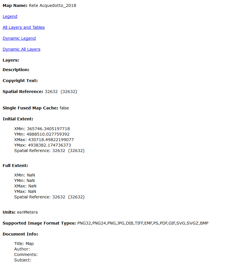
Take this as example: Rete_Acquedotto (MapServer)
There's nothing under "Layers" parameter, the full extent is all NaNs, and obviously, when I click "View in: ArcGIS JavaScript" I onkly get an empty map.
What could have caused the problem?
Could it be a network issue with the registered folder in the machine where I store the data?
I supposed that the REST should remain intact even if sometimes there's network interruption, but this seems like now my MapServers are completely corrupt!
Please help me understand the problem, I would be happy to give more details if needed.
The ArcGIS Server machine is a Windows Server 2012 R2 Stasndard.
Solved! Go to Solution.
Accepted Solutions
- Mark as New
- Bookmark
- Subscribe
- Mute
- Subscribe to RSS Feed
- Permalink
Ok, the issue was indeed a network one. Basically, to let the GIS Server access data and folders on the DB server, during install I created a local arcgis user on the GIS server, assigned a password to it, and did the same with the DB server (same password).
Unfortunately, the password on the DB server expired, and nothing worked. After I set it to never expire, I restarted the ArcGIS Server and Data Store services and everything magically came back working.
I supposed that the REST should remain intact even if sometimes there's network interruption, but this seems like now my MapServers are completely corrupt!
Probably it's not like that, right?
Probably not.
- Mark as New
- Bookmark
- Subscribe
- Mute
- Subscribe to RSS Feed
- Permalink
Could it be a network issue with the registered folder in the machine where I store the data?
Most likely it is. I just noticed that the server machine is not accessing the registered dataset due to the password being expired.
I am still checking this, but the problem should be this.
Will update the answer.
I supposed that the REST should remain intact even if sometimes there's network interruption, but this seems like now my MapServers are completely corrupt!
Probably it's not like that, right?
- Mark as New
- Bookmark
- Subscribe
- Mute
- Subscribe to RSS Feed
- Permalink
Ok, the issue was indeed a network one. Basically, to let the GIS Server access data and folders on the DB server, during install I created a local arcgis user on the GIS server, assigned a password to it, and did the same with the DB server (same password).
Unfortunately, the password on the DB server expired, and nothing worked. After I set it to never expire, I restarted the ArcGIS Server and Data Store services and everything magically came back working.
I supposed that the REST should remain intact even if sometimes there's network interruption, but this seems like now my MapServers are completely corrupt!
Probably it's not like that, right?
Probably not.