- Home
- :
- All Communities
- :
- Products
- :
- ArcGIS Enterprise
- :
- ArcGIS Enterprise Questions
- :
- Re: How do I know I am using Geometry or SDE Binar...
- Subscribe to RSS Feed
- Mark Topic as New
- Mark Topic as Read
- Float this Topic for Current User
- Bookmark
- Subscribe
- Mute
- Printer Friendly Page
How do I know I am using Geometry or SDE Binary in SQL Server
- Mark as New
- Bookmark
- Subscribe
- Mute
- Subscribe to RSS Feed
- Permalink
Hi dear,
I am using SQL server 2008R2, but I am not sure I am using geometry or binary ... would anyone tell how I can find that?
- Mark as New
- Bookmark
- Subscribe
- Mute
- Subscribe to RSS Feed
- Permalink
Hi Yasser,
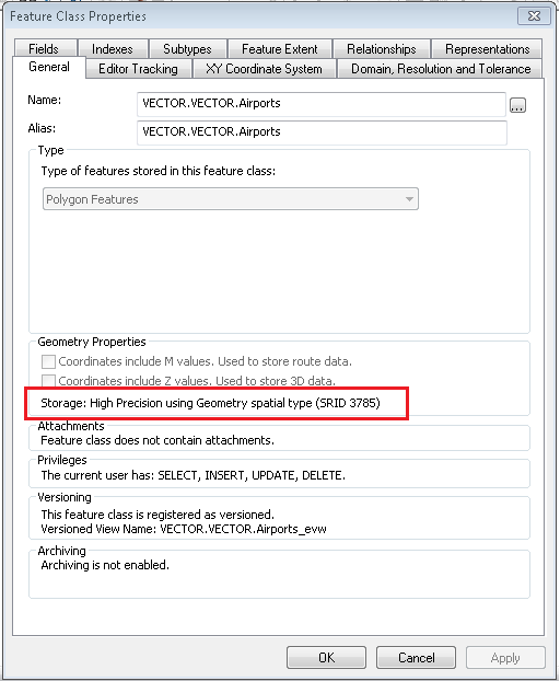
You can create/import a feature class, then right-click on the feature class > Properties. The geometry type will be listed under the General tab.
- Mark as New
- Bookmark
- Subscribe
- Mute
- Subscribe to RSS Feed
- Permalink
Thanks Jake.
Is there any recommendation by ESRI to use one "preferable" than the other one?
- Mark as New
- Bookmark
- Subscribe
- Mute
- Subscribe to RSS Feed
- Permalink
Hi Yasser
The default is always the recommendation. In this case it is geometry.
- Mark as New
- Bookmark
- Subscribe
- Mute
- Subscribe to RSS Feed
- Permalink
There are significant differences between Geography and Geometry spatial types in SQL, and I'd by no means accept the "default" without determining what storage format best fits your data needs. Without going down the rabbit hole of this is better than that, check out Spatial Data Types Overview for a detailed description of both. It boils down to your choice of coordinate system and desired precision of measurements. Personally, I'm a fan of geography....
- Mark as New
- Bookmark
- Subscribe
- Mute
- Subscribe to RSS Feed
- Permalink
You can also look at the table from Management Studio. If the database reports the geometry column as an integer, then it's using SDEBINARY geometry storage.
- V
- Mark as New
- Bookmark
- Subscribe
- Mute
- Subscribe to RSS Feed
- Permalink
Otherwise the DataType for the column will be geometry or geography for SQL Server spatial types.
You can check this from the table designer
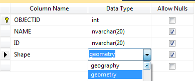
or
select DATA_TYPE
from INFORMATION_SCHEMA.COLUMNS
where COLUMN_name = 'shape'
AND TABLE_NAME = 'YOUR_TABLE'
- Mark as New
- Bookmark
- Subscribe
- Mute
- Subscribe to RSS Feed
- Permalink
Thank you all.
- Mark as New
- Bookmark
- Subscribe
- Mute
- Subscribe to RSS Feed
- Permalink
I started looking into this question when reading the documentation for editing a versioned view with SQL:
An overview of editing versioned data using SQL—Help | ArcGIS Desktop
The versioned feature classes you want to edit use a binary geometry storage type (when editing a named version)
If editing feature classes, the feature classes use SQL spatial types, not binary geometry storage (when editing the Default version)
How To: Determine which type of geometry storage is being used for a particular dataset