- Home
- :
- All Communities
- :
- Products
- :
- ArcGIS Enterprise
- :
- ArcGIS Enterprise Questions
- :
- ArcGIS Hub / Enterprise Sites: Is there any docume...
- Subscribe to RSS Feed
- Mark Topic as New
- Mark Topic as Read
- Float this Topic for Current User
- Bookmark
- Subscribe
- Mute
- Printer Friendly Page
ArcGIS Hub / Enterprise Sites: Is there any documentation on how to get symbology?
- Mark as New
- Bookmark
- Subscribe
- Mute
- Subscribe to RSS Feed
- Permalink
Hello,
I am building an OpenData Site based on ArcGIS Hub / Enterprise Sites.
I wonder if there is any documentation on how to configure it in a way that symbology is being shown in the little mapviewer. I found out that if I share a Feature Layer it never shows symbology. However, if I share a Map Image Layer it sometimes does.
I have around 300 datasets that are all shared in the same way using a Python script. In half of the cases a symbology is shown, in the other cases not. Is there any documentation on how I need to configure my data before publishing it to ArcGIS Hub / Enterprise sites such that I can get a symbology?
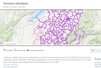
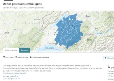
Please see screenshots below for reference:
with symbology:

without symbology

Thanks,
Martin
Solved! Go to Solution.
Accepted Solutions
- Mark as New
- Bookmark
- Subscribe
- Mute
- Subscribe to RSS Feed
- Permalink
Hey there Martin,
Thank you for reaching out and I apologize for the time it has taken me to reply. There is an active enhancement for this issue (albeit for ArcGIS Online): ENH-000099492: Open Data does not support feature layer symbology and every symbology appears in default blue color.
This defect is currently in Product Plan, meaning that the product team will may address this issue in time. Even though it's logged for ArcGIS Online, it will make its way into ArcGIS Enterprise. Please log a case with Esri Technical Support to have your account added to the enhancement. This was you will know when the issue will be addressed.
- Mark as New
- Bookmark
- Subscribe
- Mute
- Subscribe to RSS Feed
- Permalink
I'm still having this issue in 2024. Would love to be able to have my symbologies displayed when my users look for data.
- Mark as New
- Bookmark
- Subscribe
- Mute
- Subscribe to RSS Feed
- Permalink
@JonEmch any updates on the enhancement you mentioned? There are a number of posts and ideas that reference the need for this functionality.
https://community.esri.com/t5/arcgis-hub-questions/change-color-for-data-preview/td-p/1018728
- Mark as New
- Bookmark
- Subscribe
- Mute
- Subscribe to RSS Feed
- Permalink
Hello Ariel, The enhancement was closed as a known limit with the following closure text:
"Available workaround is to bring into web map to express cartography. While we have integrated some smart styling functionality into the feature layer visualization workflow, we have no plans of integrating future symbology representation at this time."
- Mark as New
- Bookmark
- Subscribe
- Mute
- Subscribe to RSS Feed
- Permalink
I know that this is late, but this seems to be a major oversight. Arcpy does this naturally, I have written my own module for creating the symbology, so you'd think that ESRI would be able to too.
- Mark as New
- Bookmark
- Subscribe
- Mute
- Subscribe to RSS Feed
- Permalink
@JamesLabadorfWould it be possible to share your script?