Turn on suggestions
Auto-suggest helps you quickly narrow down your search results by suggesting possible matches as you type.
Cancel
- Home
- :
- All Communities
- :
- Products
- :
- ArcGIS Enterprise
- :
- ArcGIS Enterprise Portal Questions
- :
- Re: How to reduce number of contours?
Options
- Subscribe to RSS Feed
- Mark Topic as New
- Mark Topic as Read
- Float this Topic for Current User
- Bookmark
- Subscribe
- Mute
- Printer Friendly Page
How to reduce number of contours?
Subscribe
16358
8
06-17-2014 02:34 AM
06-17-2014
02:34 AM
- Mark as New
- Bookmark
- Subscribe
- Mute
- Subscribe to RSS Feed
- Permalink
Hi there,
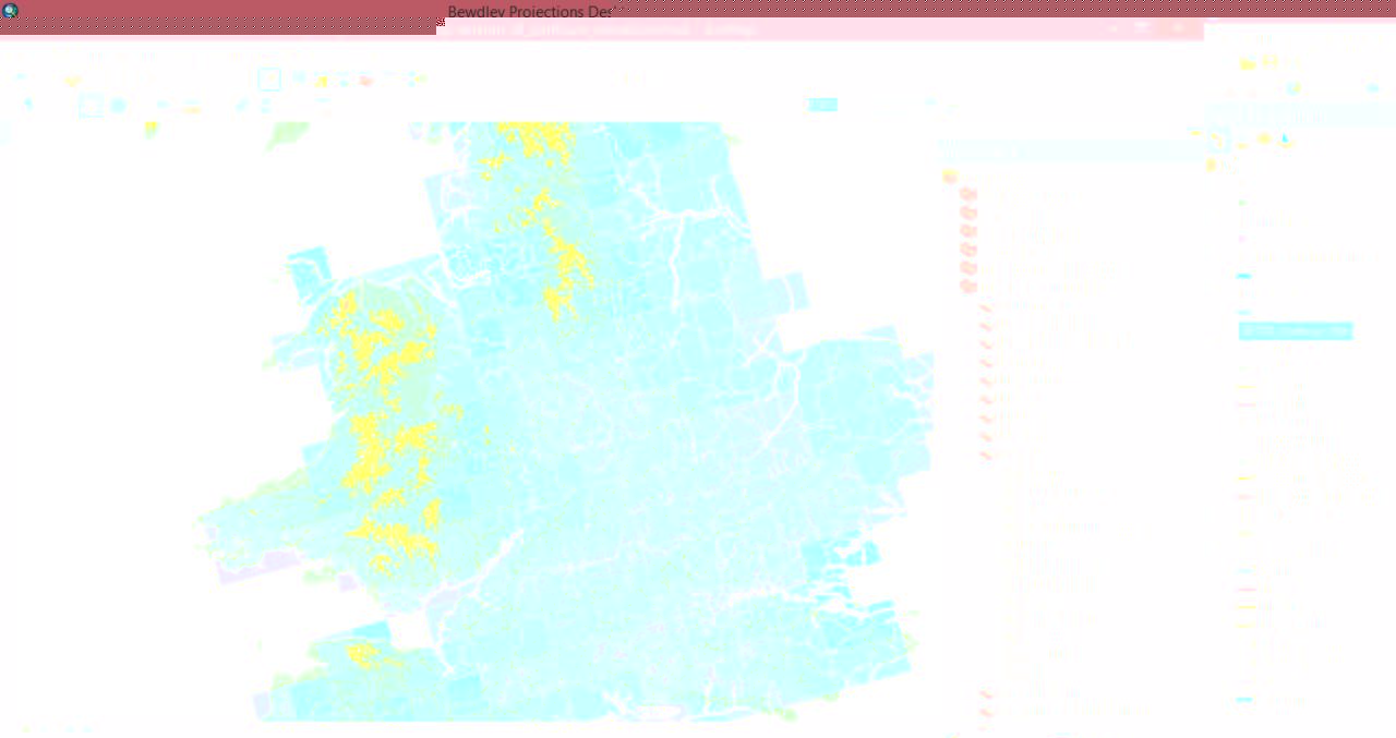
I am currently exploring a project on flood risk along the River Severn in the UK. I am using future precipitation projections from the UKCP09 model and given topography is very important as to how catchments respond to rainfall, I have added a contour map using SRTM data available for the UK here: http://www.sharegeo.ac.uk/handle/10672/9?show=full
It looks good however is there a way to simplify the number of contours on the map? As you can see in Figure 1 (attached), especially over Wales, it looks rather messy and is blocking out the data from the precipitation projections. If it could show contours say every 100m/150m/200m that would be even better?
I so, where do I need to go for this and if there is code involved say using a calculator, what would I need to use?
Cheers.
http://forums.arcgis.com/attachment.php?attachmentid=34639&stc=1&d=1403001196
8 Replies
06-17-2014
05:04 AM
- Mark as New
- Bookmark
- Subscribe
- Mute
- Subscribe to RSS Feed
- Permalink
You could use the Like operator and wildcards to create a selection or definition query that limits what gets displayed. For instance "Your field name" LIKE '%0' on a text field of contour values (you may have to add a text field and use the calculator to copy the number values into it) will give you all contours that end in 0. "Your field name" LIKE '%0' or "Your field name" LIKE '%5' will give you all contours that end in 0 or 5. If you use it in a definition query then only those lines will show. If you use it in a selection query you can create a layer in your project that will only contain those contours or you could export to a new dataset.
06-17-2014
05:39 AM
- Mark as New
- Bookmark
- Subscribe
- Mute
- Subscribe to RSS Feed
- Permalink
I often use a MOD() statement to filter with a definition query.
For Example, mod(contour, 50) = 0
takes each contour value, divides it by 50, and if the remainder is 0, it keeps it. Makes for an easy efficient way to thin contours.
Best Regards,
Jim
For Example, mod(contour, 50) = 0
takes each contour value, divides it by 50, and if the remainder is 0, it keeps it. Makes for an easy efficient way to thin contours.
Best Regards,
Jim
06-17-2014
06:01 AM
- Mark as New
- Bookmark
- Subscribe
- Mute
- Subscribe to RSS Feed
- Permalink
Additionally you can use Round as follows:
contour/100 = Round(contour/100, 0)
The mod operator may have other syntax required depending on the database, such as % or contour mod 50. You need to check the specific database to know which to use.
contour/100 = Round(contour/100, 0)
The mod operator may have other syntax required depending on the database, such as % or contour mod 50. You need to check the specific database to know which to use.
06-17-2014
06:44 AM
- Mark as New
- Bookmark
- Subscribe
- Mute
- Subscribe to RSS Feed
- Permalink
If, like me, you are not a regular professional user of ArcGIS, then
the simplest, one-off way of doing this is to open the Attribute
Table and simply delete the lines (contour levels) you do not want.
By clicking at the top of the Elevation column in the Attribute Table,
the data are sorted by elevation, so the selection of the lines to
delete is easy.
Its crude (I'm sure profi's will wince at the idea) - but quick.
But make a back-up (copy) of the original file with all the contours first
06-17-2014
07:05 AM
- Mark as New
- Bookmark
- Subscribe
- Mute
- Subscribe to RSS Feed
- Permalink
Thanks for the responses so far, I take it I need to use the 'Definition Query' function in Properties when right clicking on the contour layer? 🙂
06-17-2014
07:35 AM
- Mark as New
- Bookmark
- Subscribe
- Mute
- Subscribe to RSS Feed
- Permalink
I would use the definition query. Just make it simple and use a wildcard like function for contours ending in 0 (zero)
something like
[Elevation-Field] like '%0' or [Elevation-Field] like '*0'
whatever your elevation field is. This will look for all the contours that end in 0 or whatever number you put in there.
The % sign and the * are wild cards. * works for geodatabases and % works for shapefiles and or SDE I forget which. If one does not work try the other.,
Thanks for the responses so far, I take it I need to use the 'Definition Query' function in Properties when right clicking on the contour layer? 🙂
06-17-2014
07:36 AM
- Mark as New
- Bookmark
- Subscribe
- Mute
- Subscribe to RSS Feed
- Permalink
I would use the definition query. Just make it simple and use a wildcard like function for contours ending in 0 (zero)
something like
[Elevation-Field] like '%0' or [Elevation-Field] like '*0'
whatever your elevation field is. This will look for all the contours that end in 0 or whatever number you put in there.
The % sign and the * are wild cards. * works for geodatabases and % works for shapefiles and or SDE I forget which. If one does not work try the other.,
If his contour field is numeric this option will not work. This only works with text fields. Most contour/elevation fields are numeric, so if that is the case one of the other answers will work, but not this one.
06-17-2014
07:58 AM
- Mark as New
- Bookmark
- Subscribe
- Mute
- Subscribe to RSS Feed
- Permalink
Thanks all, I used the contour/100 = Round(contour/100, 0) option from above and that seemed to work perfectly fine. Looks neater now. 🙂