Turn on suggestions
Auto-suggest helps you quickly narrow down your search results by suggesting possible matches as you type.
Cancel
- Home
- :
- All Communities
- :
- Products
- :
- ArcGIS Enterprise
- :
- ArcGIS Enterprise Portal Questions
- :
- DDP - clip to page and excluded layers
Options
- Subscribe to RSS Feed
- Mark Topic as New
- Mark Topic as Read
- Float this Topic for Current User
- Bookmark
- Subscribe
- Mute
- Printer Friendly Page
DDP - clip to page and excluded layers
Subscribe
2465
4
02-22-2013 06:13 AM
02-22-2013
06:13 AM
- Mark as New
- Bookmark
- Subscribe
- Mute
- Subscribe to RSS Feed
- Permalink
I am having a problem getting the "clip to current data driven page extent" to work as I expect it with my map books. It seems to work fine until I want to exclude layers from the clipping. I've attached an example of what happens - the strip of map visible at the bottom of the screen. In that image the only exluded layer is a vector polygon layer. Has anyone encountered this and (more importantly) found a solution? I expect this is all bound up some how in the extents of the display but I haven't been able to find a combination of settings that seems to work.
[ATTACH=CONFIG]22081[/ATTACH]
[ATTACH=CONFIG]22081[/ATTACH]
4 Replies
02-22-2013
06:44 AM
- Mark as New
- Bookmark
- Subscribe
- Mute
- Subscribe to RSS Feed
- Permalink
Christopher,
Am I right in saying the blue layer is your excluded polygon layer?
If so does it actually just end there? Does it cover the entire layer that is your background layer?
Is it some weird multi-part polygon layer?
Duncan
Am I right in saying the blue layer is your excluded polygon layer?
If so does it actually just end there? Does it cover the entire layer that is your background layer?
Is it some weird multi-part polygon layer?
Duncan
02-22-2013
07:50 AM
- Mark as New
- Bookmark
- Subscribe
- Mute
- Subscribe to RSS Feed
- Permalink
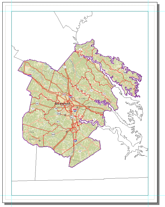
Sorry, not enough information provided initially: the blue area is simply the color of the dataframe background. I've attached two images that should help illustrate what is happening. In my map i have the following feature classes:
[ATTACH=CONFIG]22085[/ATTACH]
But on export (to any format i've tried - jpg, png, pdf), what i get is this:
[ATTACH=CONFIG]22086[/ATTACH]
As you can see, the background map is showing at the bottom where it shouldn't be..
- zones with a definition query (the purple outline)
- the zones without a definition query (this one is selected as the feature class to exclude from clipping)
- subdivisions of the zones (red outlined polygons)
- the ESRI Streets basemap
[ATTACH=CONFIG]22085[/ATTACH]
But on export (to any format i've tried - jpg, png, pdf), what i get is this:
[ATTACH=CONFIG]22086[/ATTACH]
As you can see, the background map is showing at the bottom where it shouldn't be..
02-22-2013
08:51 AM
- Mark as New
- Bookmark
- Subscribe
- Mute
- Subscribe to RSS Feed
- Permalink
Well, booger.. and we aren't quite ready to upgrade as of yet.. but perhaps this will be a driver as this sort of functionality is so useful. Thanks!
02-26-2013
06:15 AM
- Mark as New
- Bookmark
- Subscribe
- Mute
- Subscribe to RSS Feed
- Permalink
Thanks, upgrading seems to have fixed the issue... though I think i'm generally seeing brutally slow exports when clipping.