- Home
- :
- All Communities
- :
- Products
- :
- ArcGIS Reality
- :
- ArcGIS Drone2Map
- :
- ArcGIS Drone2Map Questions
- :
- Re: Using a NZ Vertical Coordinate System
- Subscribe to RSS Feed
- Mark Topic as New
- Mark Topic as Read
- Float this Topic for Current User
- Bookmark
- Subscribe
- Mute
- Printer Friendly Page
- Mark as New
- Bookmark
- Subscribe
- Mute
- Subscribe to RSS Feed
- Permalink
Hi there
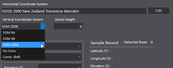
Looking at the Drone2Map Vertical Coordinate System
We can use NZGD2000 NZ Transverse Mercator (2193)
However we would like to use a local circuit for Vertical Coordinate System - but there are the following showing
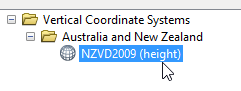
New Zealand Vertical Datum 2009 (NZVD2009) | Land Information New Zealand (LINZ)
I note that NZVD2009 is supported in ArcMap
However also we would like to use
New Zealand Vertical Datum 2016 (NZVD2016) | Land Information New Zealand (LINZ)
Is there a way to enter in a custom system?
Thanks
John P
Solved! Go to Solution.
Accepted Solutions
- Mark as New
- Bookmark
- Subscribe
- Mute
- Subscribe to RSS Feed
- Permalink
John,
Drone2Map currently supports three Geoid Models: EGM 84, EGM 96, and EGM 2008. To model a different geoid you will use the 'Const. Shift' option and then enter the positive or negative shift between the spheroid/ellipsoid of the XY coordinate system (in this case, GRS_1980) and your desired geoid. Note that the terms spheroid and ellipsoid are often used interchangeably.
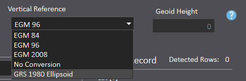
Drone2Map version 1.1 will be released this week, and the Vertical Reference drop down will be clarified. Instead of 'Const. Shift' you will choose 'GRS 1980 Ellipsoid'. If your heights are with respect to the GRS 1980 Spheroid (i.e. ellipsoidal height) then leave Geoid Height at 0. If your heights are with respect to a geoid (i.e. orthometric height) then enter the positive or negative offset of the geoid with respect to the GRS 1980 Spheroid.
Please note, if you're creating a 3D Textured Mesh, and wish to display it in ArcGIS Online or ArcGIS Pro, then with version 1.1 of Drone2Map you will have the option to specify that output products be converted to EGM 96. This is the reference system used by these products for elevation.
~Roslyn Dunn
- Mark as New
- Bookmark
- Subscribe
- Mute
- Subscribe to RSS Feed
- Permalink
John,
Drone2Map currently supports three Geoid Models: EGM 84, EGM 96, and EGM 2008. To model a different geoid you will use the 'Const. Shift' option and then enter the positive or negative shift between the spheroid/ellipsoid of the XY coordinate system (in this case, GRS_1980) and your desired geoid. Note that the terms spheroid and ellipsoid are often used interchangeably.
Drone2Map version 1.1 will be released this week, and the Vertical Reference drop down will be clarified. Instead of 'Const. Shift' you will choose 'GRS 1980 Ellipsoid'. If your heights are with respect to the GRS 1980 Spheroid (i.e. ellipsoidal height) then leave Geoid Height at 0. If your heights are with respect to a geoid (i.e. orthometric height) then enter the positive or negative offset of the geoid with respect to the GRS 1980 Spheroid.
Please note, if you're creating a 3D Textured Mesh, and wish to display it in ArcGIS Online or ArcGIS Pro, then with version 1.1 of Drone2Map you will have the option to specify that output products be converted to EGM 96. This is the reference system used by these products for elevation.
~Roslyn Dunn