- Home
- :
- All Communities
- :
- Products
- :
- ArcGIS Reality
- :
- ArcGIS Drone2Map
- :
- ArcGIS Drone2Map Questions
- :
- Re: the current authertication portal has no valid...
- Subscribe to RSS Feed
- Mark Topic as New
- Mark Topic as Read
- Float this Topic for Current User
- Bookmark
- Subscribe
- Mute
- Printer Friendly Page
the current authertication portal has no valid default basemap.an empty basemap has been loaded
- Mark as New
- Bookmark
- Subscribe
- Mute
- Subscribe to RSS Feed
- Permalink
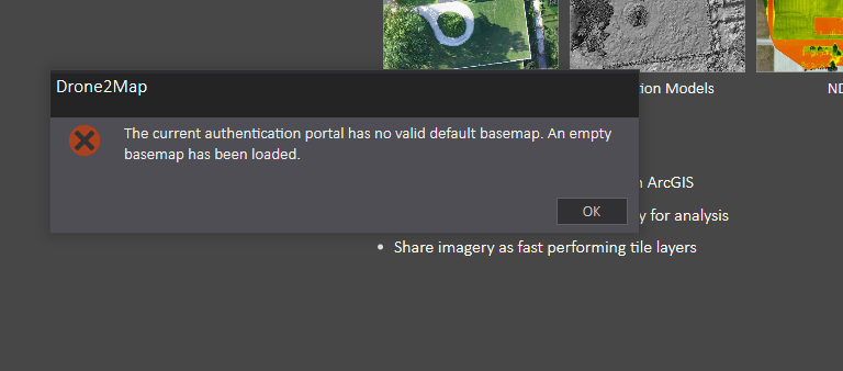
when i run the drone2map program,the program tell me that" the current authertication portal has no valid default basemap.an empty basemap has been loaded"
like the picture

can you tell me how to resolve the problem?
thanks
dm2.log:
2017-02-21 16:24:00,457 INFO - Adding sharing portal https://www.arcgis.com
2017-02-21 16:24:36,515 INFO - Runtime Licensed
2017-02-21 16:36:17,843 INFO - Adding sharing portal https://www.arcgis.com
2017-02-21 16:36:45,858 INFO - Runtime Licensed
2017-02-21 16:38:35,318 INFO - Adding sharing portal https://www.arcgis.com
2017-02-21 16:38:59,543 INFO - Runtime Licensed
2017-02-21 16:47:05,454 INFO - Adding sharing portal https://www.arcgis.com
2017-02-21 16:48:36,157 INFO - Adding sharing portal https://www.arcgis.com
2017-02-21 16:53:38,954 INFO - Adding sharing portal https://www.arcgis.com
2017-02-21 17:01:31,844 INFO - Adding sharing portal https://www.arcgis.com
- Mark as New
- Bookmark
- Subscribe
- Mute
- Subscribe to RSS Feed
- Permalink
Hi Hailian,
Could you provide a few more details?
- You are connecting to ArcGIS Online for authentication right (looks like it from your log)? Not Portal for ArcGIS?
- What type of Basemap do you have as your default basemap in your organization - Custom built or Esri standard?
- Are you using Drone2Map in offline mode?
I'm not sure if Drone2Map can consume custom basemaps, we would need to wait for an Esri employee to reply to that. But that could be an issue.
Also try switching the default basemap setting in your Organization, and see if that helps. You'll need to be an administrator of the organization to do that.
/Lars
- Mark as New
- Bookmark
- Subscribe
- Mute
- Subscribe to RSS Feed
- Permalink
Hi hailian2,
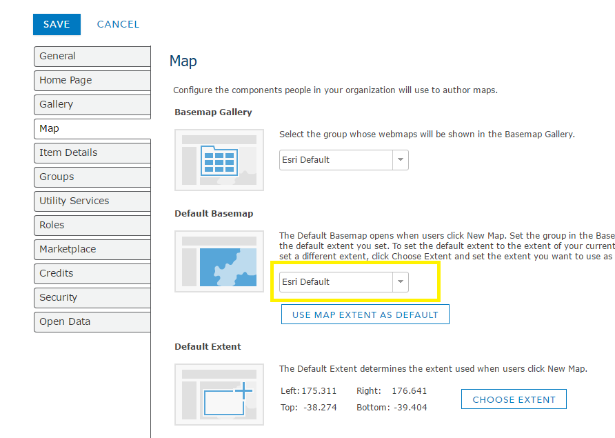
Please check which setting your organization is using for the Basemap Gallery (My Organization > Edit Settings > Map > Basemap Gallery). If your organization is using a custom basemap group, please ensure that a Default Basemap is identified. You should see a warning in the Default Basemap dropdown list if a valid basemap is not selected.
Jeremy
- Mark as New
- Bookmark
- Subscribe
- Mute
- Subscribe to RSS Feed
- Permalink
Jeremy Schuyler I have this same issue but I don't understand how to resolve it. According to ArcGIS online our organisational basemaps are set to ESRI default. When I try to look at offline basemaps in Drone2Map is does not let me use the option of ESRI default base maps??


- Mark as New
- Bookmark
- Subscribe
- Mute
- Subscribe to RSS Feed
- Permalink
If you are authenticated to an AGOL organization and it is using the Esri Default basemap group then you should be able to download offline basemaps from there. The basemaps displayed in D2M are from services.arcgisonline.com (e.g. https://services.arcgisonline.com/ArcGIS/rest/services/World_Imagery/MapServer) and offline basemaps will be downloaded from tiledbasemaps.arcgis.com. (e.g. https://tiledbasemaps.arcgis.com/ArcGIS/rest/services/World_Imagery/MapServer).
Please see if you can access both https://services.arcgisonline.com/ArcGIS/rest/services/World_Imagery/MapServer and https://tiledbasemaps.arcgis.com/ArcGIS/rest/services/World_Imagery/MapServer from your D2M machine.
You will need to clear the group you have set in Application Settings/Offline Basemaps as shown below, to download Offline Basemaps.

If downloading offline basemaps still is not working for you then I would be interested in viewing your D2M.log file. Please set the logging level to debug, attempt to download a basemap and send me the "C:\Users\<user>\AppData\Local\Drone2Map\log\D2M.log"

The offline basemap settings in Application Settings are intent for organizations authenticating to a portal behind a firewall that do not have access to AGOL.

The group in this section of Application Settings is intended for organization that are authenticating to a Portal behind a firewall that does not have access to services.arcgisonline.com and tiledbasemaps.arcgis.com. In this case they would have to set up a group containing their custom basemaps and set that group as their basemap gallery in their portal organization settings. If they wish to use the offline basemap functionality on D2M they would also have to create a group in their portal containing "tiled" versions of their basemaps and select that group in D2M/Application Settings/Offline Basemaps.
- Mark as New
- Bookmark
- Subscribe
- Mute
- Subscribe to RSS Feed
- Permalink
Hi James Taylor
I have made a little progress with Drone2Map. When creating a new project I had been attempting to use NZTM as the projection as Eagle (New Zealand ESRI supplier) has created basemaps using NZTM that we often use. This time I kept to WGS and it has now allowed me to see my photo spots, yet still no basemaps.
I have tried to follow this course Create 3D data from 2D imagery—Get Started with Drone2Map for ArcGIS | ArcGIS and use their data but I cannot see the mesh or the basemap, however I have opened the PDF created after processing and have managed to get an image.
I read Offline use—Drone2Map for ArcGIS Help | ArcGIS to try and figure out how to download an offline basemap but as you will see in the picture below it mentions an offline content button under tools I cannot see such a button on my application. I have tried to right click in numerous places too but cannot find anything that says download.
Picture 1) error that pops up when I start Drone2Map
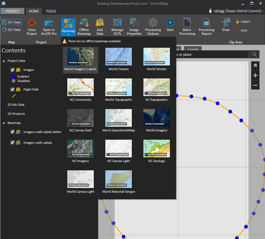
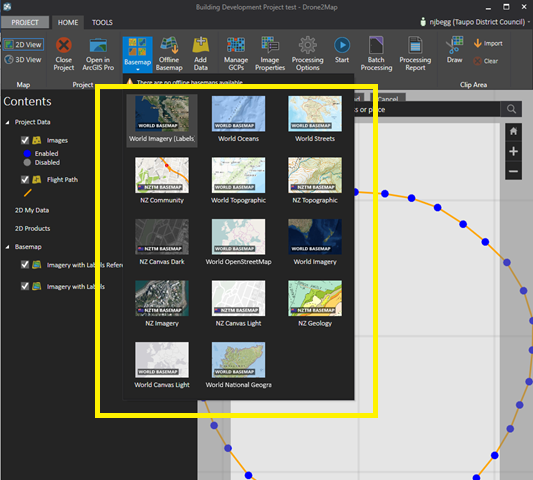
Picture 2) No Basemaps appear to be available even offline.
Picture 3) I somehow tried to download something (turns out it was the basemap that wasn't viewable anyway) and have the following download error.
Picture 4) Image created using course material.
Picture 5) Trying to find how to download basemap.


- Mark as New
- Bookmark
- Subscribe
- Mute
- Subscribe to RSS Feed
- Permalink
Hi Naomi,
Sorry for the problems you are seeing.
First one, the Image Points and Flight Lines not displaying in NTZM is known issue. Projected coordinate systems are not being displayed properly. You can still run processing and it should work fine, even thought you can't see the Image Points and Flight Lines, however the results won't display in the application correctly unless your Output Coordinate System is set to WGS or UTM.

If you use a projected output coordinate system the products will still be available to use in other products (like ArcMap or ArcGIS Pro). They will be located at C:\Users\<user>\Documents\Drone2Map Projects\<project>\products
The basemap problem. It looks like your AGOL Organization doesn't have a default basemap set. Try going to your organizations settings and make sure it's set.

It looks like you have access to the basemaps in Drone2Map, try selecting one and see if it displays.

If one displays then you should be able to click the Offline Basemap button in the Layers menu to download that basemap.
- Mark as New
- Bookmark
- Subscribe
- Mute
- Subscribe to RSS Feed
- Permalink
Hi James
I have ESRI default basemaps selected within our AGOL organisational settings.
When I click on the basemap World Imagery (Labels), or any of the others, nothing appears on the screen.
However I do appear to be able to download parts of basemaps over my data in New Zealand, but not over the test data provided in the drone2map course which I am presuming is over USA.
- Mark as New
- Bookmark
- Subscribe
- Mute
- Subscribe to RSS Feed
- Permalink
Hi,
Could you verify that you have access to the basemap services by going to the following URLs in a web browser. You should see a description of the service:
http://services.arcgisonline.com/ArcGIS/rest/services/World_Imagery/MapServer
http://services.arcgisonline.com/ArcGIS/rest/services/World_Topo_Map/MapServer
http://services.arcgisonline.com/ArcGIS/rest/services/World_Street_Map/MapServer
http://services.arcgisonline.com/arcgis/rest/services/Canvas/World_Dark_Gray_Base/MapServer
http://services.arcgisonline.com/ArcGIS/rest/services/NatGeo_World_Map/MapServer
http://services.arcgisonline.com/arcgis/rest/services/Ocean/World_Ocean_Base/MapServer
http://services.arcgisonline.com/ArcGIS/rest/services/World_Terrain_Base/MapServer
Also could you do this:
- Start Drone2Map
- Go to Settings/System Settings
- Select "Debug" in the top most dropdown (Set the log level for messages logged by Drone2Map for ArcGIS)
- Click Save
- Exit Drone2Map
- Restart Drone2Map
- Select a couple different basemaps
- Exit Drone2Map
- Send me the file: "C:\Users\<user>\AppData\Local\Drone2Map\log\D2M.log"
I will send you my email in a private message.
Thanks,
jt
- Mark as New
- Bookmark
- Subscribe
- Mute
- Subscribe to RSS Feed
- Permalink
Hi Hailian,
Have you made any progress on this? Please review the replies I'm posted to Naomi here as I think they apply to your issue also.
I would ask that you try the same as I suggest for her:
Could you verify that you have access to the basemap services by going to the following URLs in a web browser. You should see a description of the service:
http://services.arcgisonline.com/ArcGIS/rest/services/World_Imagery/MapServer
http://services.arcgisonline.com/ArcGIS/rest/services/World_Topo_Map/MapServer
http://services.arcgisonline.com/ArcGIS/rest/services/World_Street_Map/MapServer
http://services.arcgisonline.com/arcgis/rest/services/Canvas/World_Dark_Gray_Base/MapServer
http://services.arcgisonline.com/ArcGIS/rest/services/NatGeo_World_Map/MapServer
http://services.arcgisonline.com/arcgis/rest/services/Ocean/World_Ocean_Base/MapServer
http://services.arcgisonline.com/ArcGIS/rest/services/World_Terrain_Base/MapServer
Also could you do this:
- Start Drone2Map
- Go to Settings/System Settings
- Select "Debug" in the top most dropdown (Set the log level for messages logged by Drone2Map for ArcGIS)
- Click Save
- Exit Drone2Map
- Restart Drone2Map
- Select a couple different basemaps
- Exit Drone2Map
- Send me the file: "C:\Users\<user>\AppData\Local\Drone2Map\log\D2M.log"
I will send you my email in a private message.
Thanks,
jt