- Home
- :
- All Communities
- :
- Products
- :
- ArcGIS Reality
- :
- ArcGIS Drone2Map
- :
- ArcGIS Drone2Map Questions
- :
- Imagery processing workflows for seamless mosaic ...
- Subscribe to RSS Feed
- Mark Topic as New
- Mark Topic as Read
- Float this Topic for Current User
- Bookmark
- Subscribe
- Mute
- Printer Friendly Page
Imagery processing workflows for seamless mosaic datasets?
- Mark as New
- Bookmark
- Subscribe
- Mute
- Subscribe to RSS Feed
- Permalink
Cheers, All.
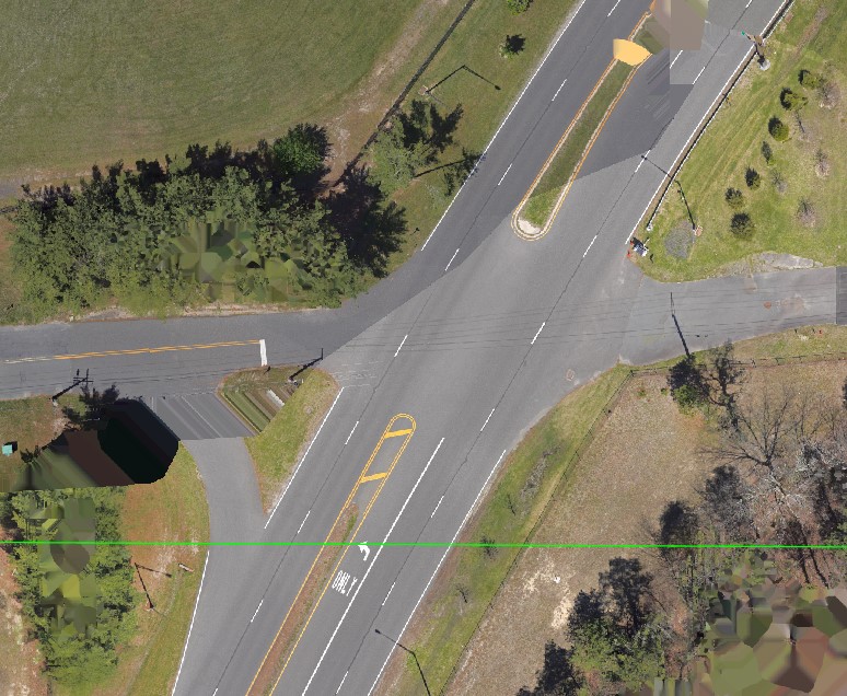
We recently began doing basemap updates on our campus and I am having trouble finding the best tools and documentation for tonal adjustments. I've attached a few images to show the types of problems I am facing (Don't mind the artifacting, I just haven't cleaned up the edges where there wasn't much overlap). I did my best to do batch adjustments in photoshop/lightroom before processing the captured images in Drone2Map but there is still significant variance from flight to flight even after color balancing the mosaic and the end result will be 100s of thousands of images. Thanks!
- Mark as New
- Bookmark
- Subscribe
- Mute
- Subscribe to RSS Feed
- Permalink
That "Road" result does not look normal - you should not see sharp edges from different images. Can you confirm which version of Drone2Map you're using, and the settings you applied?
- Mark as New
- Bookmark
- Subscribe
- Mute
- Subscribe to RSS Feed
- Permalink
Hi Cody, sorry if my initial explanation was not clear. The differences in the road is because that is a .jpg of a boundary of 2 different rasters that were flown weeks apart. The individual rasters look fine on their own, where I'm having trouble is bringing them into a mosaic dataset to make seamless imagery. Hope this clears things up.
The imagery is all captured at 200 ft 70/80 and processed in Drone2Map with mostly default settings at 2cm/pixel. Some of the flights were flown with auto-ISO on less than ideal days and I'm doing my best to adjust the imagery in post-processing so we don't have to refly.
- Mark as New
- Bookmark
- Subscribe
- Mute
- Subscribe to RSS Feed
- Permalink
Morgan - thanks, knowing those were completely different dates does make the color correction more challenging.
Can you clarify terminology and workflow? You said "mosaic dataset" and I just want to clarify how you're using them. https://pro.arcgis.com/en/pro-app/latest/help/data/imagery/mosaic-datasets.htm
Are you processing date 1 in Drone2Map, then a separate project for date 2 (etc.), creating multiple true orthos for different sections of campus, then managing those orthos using a mosaic dataset? Presumably intending to create a raster tile cache (basemap) out of the mosaic dataset when campus is complete?
If correct, this is a perfectly valid workflow for the geometry of the pixels, but unfortunately color correction will be much more difficult because each true ortho is adjusted for color, but the edges will be impossible to match. I'd suggest one of three alternatives to improve the tonal mismatch between orthos:
1) fastest/easiest is to apply blending across the seamlines between the true orthos, and you should be able to apply a wide blend distance (? 10 meters?) if you have adequate overlap. (And for future flights, ensure a lot of overlap between the output orthos, e.g. 2 full flightlines if possible). This should look relatively good at large scale (zoomed way in) but when you zoom out, you'll still see tonal differences between the flights.
2) another option is to process all drone images in a single Drone2Map project - this should automatically compensate for the tonal differences but depending on total number of images the project may be too large. (Do you have access to the ArcGIS Reality Extension for Pro? That should allow you to scale to a larger single project)
3) I was going to describe a third option but I'm pretty sure this will not yield acceptable results. You could use Drone2Map flight-by-flight to run photogrammetric processing but not create true orthos, then apply the exterior orientation (xyz, omega phi kappa) for all of the individual frames using a mosaic dataset to rectify the images on-the-fly; but this won't give you a true ortho, and with a 200' flight over campus buildings the horizontal layover will be unacceptable. (if you ever had to do a large project over natural terrain, this approach might be perfectly acceptable)
Cody
- Mark as New
- Bookmark
- Subscribe
- Mute
- Subscribe to RSS Feed
- Permalink
Your explanation of the workflow is exactly how we are attempting to do things. I appreciate the detailed feedback.
1) This seems like the best option, I will do some more research about this.
2) Yes, we have reality but I am waiting to have it moved to another machine. The final product is going to be 1000s of acres and Drone2Map maxes out at 300 gigapixels (about 4500-5000 images), so its a huge limiting factor.
Thank you.