- Home
- :
- All Communities
- :
- Products
- :
- ArcGIS Collector
- :
- ArcGIS Collector Questions
- :
- Re: ArcGIS Server/Online and Editable Feature Serv...
- Subscribe to RSS Feed
- Mark Topic as New
- Mark Topic as Read
- Float this Topic for Current User
- Bookmark
- Subscribe
- Mute
- Printer Friendly Page
ArcGIS Server/Online and Editable Feature Services
- Mark as New
- Bookmark
- Subscribe
- Mute
- Subscribe to RSS Feed
- Permalink
I have two rather in depth questions. The scenario is, I am attempting to publish an editable feature service on ArcGIS Server then add that Feature Service to ArcGIS Online, bring it into a web map, and consume/edit the web map/feature service with Collector. In addition, I would ideally like to take the web map offline with Collector.
My environment is ArcGIS Server 10.2.2, along with ArcGIS desktop 10.2.2, we have an organizational ArcGIS Online account, and our data is hosted in an Oracle SDE database (unsure of Oracle version).
I can successfully publish a map service with feature access enabled and all capabilities except sync. I followed the data preparation for offline use but cannot enable archiving on a nonversioned feature class. My first question is my inability to sync related to my Oracle SDE?
My second question is how do I enable editing when consuming the feature service in ArcGIS Online? I added the feature service to ArcGIS Online by Adding an Item, from the Web, Type = ArcGIS Server web service and provide the full URL (example http://ags-mobile/arcgis/rest/services/Mobile/Edit/MapServer/0). However, once added editing does not appear to be available.
Thank you for any help or suggestions, currently none of my data is publicly shared.
Solved! Go to Solution.
Accepted Solutions
- Mark as New
- Bookmark
- Subscribe
- Mute
- Subscribe to RSS Feed
- Permalink
Working with Esri I was able to identify the issue. My SDE geodatabase is at 10.0 which does not support the capabilities I am attempting. It is not a database (Oracle) or geometry type issue. My desktop and ArcGIS Server are at 10.2 but not SDE. I'm in discussions to upgrade the SDE which hopefully will occur next week. I'll revisit this post once upgraded and likely mark all of your responses as correct. Thanks again and next time I will be more diligent about all of my environment settings. 
- Mark as New
- Bookmark
- Subscribe
- Mute
- Subscribe to RSS Feed
- Permalink
Ben,
part of the answer is that you need to add a url that references the feature service, not the map service (example http://ags-mobile/arcgis/rest/services/Mobile/Edit/FeatureServer/0). Archiving of versioned vs. non-versioned objects has changed over the past few geodatabase versions (it changed from 10.1 to 10.2 but I can't remember the details), so you might want to look into that rather than into what version of Oracle database your geodatabase resides in.
- Mark as New
- Bookmark
- Subscribe
- Mute
- Subscribe to RSS Feed
- Permalink
Hi Ben,
Tobias's answer will address your second question. For your first question, are you receiving an error when you try to enable archiving?
- Mark as New
- Bookmark
- Subscribe
- Mute
- Subscribe to RSS Feed
- Permalink
Thank you Tobias and Jake for your help. Below are my results after applying your suggestions.
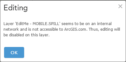
Tobias's suggestion (changing Map to FeatureServer) did allow me to add the Feature Service to AGOL and it appears that this is the correct procedure for editing. However, I ran into another issue which is now related to my internal network and perhaps no one will be able to help accept my IT. When I add the layer to a web map I receive this error "Editing Layer "EditMe-MOBILE.SPILL" seems to be on an internal network and is not accessible to ArcGIS.com. Thus, editing will be disabled on this layer" (screen shot attached). Any suggestion on what I need to ask of my IT, open a certain port?
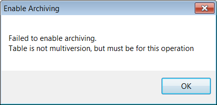
Jake, I'm not receiving an error when I attempt to enable archiving but I receive this message. "Failed to enable archiving. Table is not multiversion, but must be for this operation" (screen shot attached). My understanding is data for offline use must be Nonversioned, archiving enabled, and include Global IDs. I can't enable archiving without versioning the feature class. Is there another way to set things up to achieve sync/offline use?
Thanks again, the help you both are providing is genuinely appreciated
- Mark as New
- Bookmark
- Subscribe
- Mute
- Subscribe to RSS Feed
- Permalink
If you have the web adaptor installed, try bypassing it by specifying port 6080 in the url. Ex:
http://ags-mobile:6080/arcgis/rest/services/Mobile/Edit/FeatureServer/0
Are you still able to reproduce the error when adding the layer to AGOL?
Data can be registered as versioned to enable sync capabilities. See the link below:
ArcGIS Help (10.2, 10.2.1, and 10.2.2)
One important thing to note:
The sync capability can only be enabled when all the data in the map is configured exactly the same; you cannot have a mix of data with differing configurations.
- Mark as New
- Bookmark
- Subscribe
- Mute
- Subscribe to RSS Feed
- Permalink
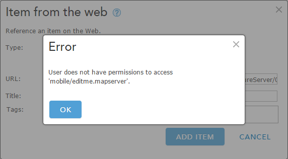
Thanks Jake. I think my corporate network/firewall may be the issue keeping me from using the standard workflows. When I add the port 6080 to the URL I get an "Error User does not have permissions to access 'mobile/editme.mapserver" (screen shot). In summary, if I do not specify the port I can add and view the feature service but not edit. If I specify the port it returns an error immediately and does not add the feature service to AGOL.
For you suggestion on preparing data for offline use I reread the criteria. It's my desire that the end user be able to take data offline, edit it, and synchronize when back on WiFi. Therefore this statement from the help leads me to believe I must have nonversioned data "If clients will be editing data while offline and sychronizing their changes when they have connectivity, the feature service must contain nonversioned data." Just below that statement there happens to be a Note indicating that you can only enable archiving on a SQL spatial data type which is why I'm thinking our Oracle SDE may be at issue.
I think my companies specific network configuration and Oracle data storage are currently at odds with Esri's requirements. Would you agree? Again, that's for the continued feedback on this discussion.
- Mark as New
- Bookmark
- Subscribe
- Mute
- Subscribe to RSS Feed
- Permalink
Just identified my feature class geometry storage type is "High Precision using ST_Geometry spatial type (SRID 2010251530). I think this may have answered my question. Perhaps someone at Esri could chime in if there is a method for preparing data (Oracle Spatial data type ST_Geometry) for offline use.
- Mark as New
- Bookmark
- Subscribe
- Mute
- Subscribe to RSS Feed
- Permalink
Ben,
Oracle has a spatial data type named ST_Geometry, and ESRI geodatabases have a spatial data type named ST_Geometry. If you created the feature class via ArcCatalog you are likely using the ESRI one. If you are testing with a very basic feature class (Global ID's added, non-versioned, archiving enabled) all points to this not being a database issue, but a server configuration issue instead. Not sure about the error in your screenshot. Can you provide more details about the ArcGIS Server and ArcGIS Online setup?
-Tobias
- Mark as New
- Bookmark
- Subscribe
- Mute
- Subscribe to RSS Feed
- Permalink
Tobias, thanks for your reply. Yes I created a very basic feature class for testing purposes only, in our Oracle SDE with default ST_Geometry. I added Gloabal ID's, did not register as versioned, and attempted to enable archiving. That's when I got the archive error "Failed to enable archiving. Table is not multiversion, but must be for this operation." I'm at a little bit of a loss and can't identify other issues which is why I am stuck on the geometry type as the problem. Let me get back to you on the ArcGIS Service details and Online setup, hopefully this afternoon.
- Mark as New
- Bookmark
- Subscribe
- Mute
- Subscribe to RSS Feed
- Permalink
ST_GEOMETRY is a supported data type in order to enable 'Sync' capabilities. You will need to figure out why you are receiving the error when you attempt to enable archiving on the feature class. I've seen this error when attempting to enable archiving on a feature class that is stored with SDEBINARY, but not ST_GEOMETRY. It may be worth logging a tech support incident.