Turn on suggestions
Auto-suggest helps you quickly narrow down your search results by suggesting possible matches as you type.
Cancel
- Home
- :
- All Communities
- :
- Products
- :
- ArcGIS CityEngine
- :
- ArcGIS CityEngine Questions
- :
- CityEngine Terrain Map
Options
- Subscribe to RSS Feed
- Mark Topic as New
- Mark Topic as Read
- Float this Topic for Current User
- Bookmark
- Subscribe
- Mute
- Printer Friendly Page
CityEngine Terrain Map
Subscribe
15882
24
05-29-2013 01:44 AM
05-29-2013
01:44 AM
- Mark as New
- Bookmark
- Subscribe
- Mute
- Subscribe to RSS Feed
- Permalink
Hi, 🙂
I have some issues in creating a terrain in city engine. I have create a New Scene and add some data from OSM then I follow the
steps that are described in Tutorial 2/Part 1, using as Heightmap a georeferenced DEM image and as Texture a georeferenced image
from OSM. But, althougn in Arcmap they are correct in CityEngine I receive the following error: The data is located too far from
the current scene's contents. Either edit the (geo-)location of the data, choose an adequate projection, or import it into a new
empty CityEngine scene.
I have done the opposite, to create a New Scene create first the Terrain and add after the data, but I received again
the error above.
I really cant find out what is going wrong
24 Replies
08-05-2013
12:23 AM
- Mark as New
- Bookmark
- Subscribe
- Mute
- Subscribe to RSS Feed
- Permalink
I'm missing the georeferencing metadata files, like the .prj. Can you add them here ?
Note that the projection of all imported raster files need to match the target SCS ( Scene Coordinate System ) projection.
CE can reproject vector data on import, but not reproject raster files.
Let me know..
m.
Note that the projection of all imported raster files need to match the target SCS ( Scene Coordinate System ) projection.
CE can reproject vector data on import, but not reproject raster files.
Let me know..
m.
08-05-2013
08:00 AM
- Mark as New
- Bookmark
- Subscribe
- Mute
- Subscribe to RSS Feed
- Permalink
Hmm, my lacking a .prj file for the data is probably causing it then, thanks! Time to go fix that and see if that helps.
08-05-2013
10:33 AM
- Mark as New
- Bookmark
- Subscribe
- Mute
- Subscribe to RSS Feed
- Permalink
Ok, that didn't help. Original data I used didn't come with a .prj file. So after digging around, I found access to the old USGS system before they got rid of geotiff, which gave me geotiff and a .prj file.
Made no difference. Moreover, now instead of being sized right, it makes the terrain a tiny point. Enlarging the size gives me the heightmap properly, though probably not scaled at all correctly. Even then trying to use the OSM data gives me the same error.
Here's the files again, with the prj file.
08-06-2013
01:36 AM
- Mark as New
- Bookmark
- Subscribe
- Mute
- Subscribe to RSS Feed
- Permalink
hi !
I have not checked the new files since usually, there's more files, e.g. the 'world' file, which is also needed for correct placement.
Using -georeferenced data is tricky.
I'd recommend the following 2 things:
1] What I usually do :
- Import the .osm file. This usually works without issues.
- Zoom to the data with 'f'
- Drag and drop the texture file ( e.g. tif or jpg ) into the viewport, this triggers the terrain import dialog
- The size is set to the terrain's resolution, which is of course false in most cases, hit ok to create the terrain
- Select the terrain layer and use the w,e keys to move / scale the terrain to the correct spot ( eyeballing ). This usually is by far enough precise
2] If you have ArcGIS available
- Import osm into ArcGIS
- create basemap in the correct projection
- export the extent of interest as GeoTif. This will produce all the right metadata stuff.
Ok ?
Matt
ps. sorry for the inconvenience, but the metadata needs to be spot-on correct, otherwise the system is missing some info.
08-06-2013
06:28 AM
- Mark as New
- Bookmark
- Subscribe
- Mute
- Subscribe to RSS Feed
- Permalink
Well I have all that data, it's just too large to upload here 😞
Somewhat following that process, I just imported the texture, which used the default flat heightmap and put the terrain, visibly near the graph network. Proceeded to 'eyeball' it into the same scale/location, then replaced the flat heightmap with the actual one. It works now in the sense that there's the actual heightmap and roads, but don't match up properly.
I don't have ArcGIS, as I bought cityengine for making large-scale environments for a driving sim and didn't need a full GIS suite that would be more appropriate for a government or organization who used the data for policy and analysis. I just wanted an accurate road network and heightmap.
Now it looks like I'm going to need ArcGIS and ESRI's map data just to get everything to work together without errors.
08-06-2013
07:05 PM
- Mark as New
- Bookmark
- Subscribe
- Mute
- Subscribe to RSS Feed
- Permalink
Update: Problem solved!
I was looking around for how to change the coordinate data in the files so they'd match and came across a program attached in another forum here. Turns out, despite having plenty of other files with meta-data, I didn't have a world (.TFW) file. Ran the program I found and it created it. Imported perfectly.
Thanks for the help!
08-12-2013
01:15 PM
- Mark as New
- Bookmark
- Subscribe
- Mute
- Subscribe to RSS Feed
- Permalink
How to import a DEM file instrad of a heightmap?
08-19-2013
05:07 AM
- Mark as New
- Bookmark
- Subscribe
- Mute
- Subscribe to RSS Feed
- Permalink
Hi !
That's the same, just different terminology.
ok ?
m.
That's the same, just different terminology.
ok ?
m.
10-29-2014
12:54 PM
- Mark as New
- Bookmark
- Subscribe
- Mute
- Subscribe to RSS Feed
- Permalink
Hi Everybody. I am following this instruction Esri CityEngine Essentials 2: Build the Foundation
but for some reason i am not able to see the Texture how it suppose it does nor reflect the aerial it just a black image. I modify my tif file to 4000 by 4000 but 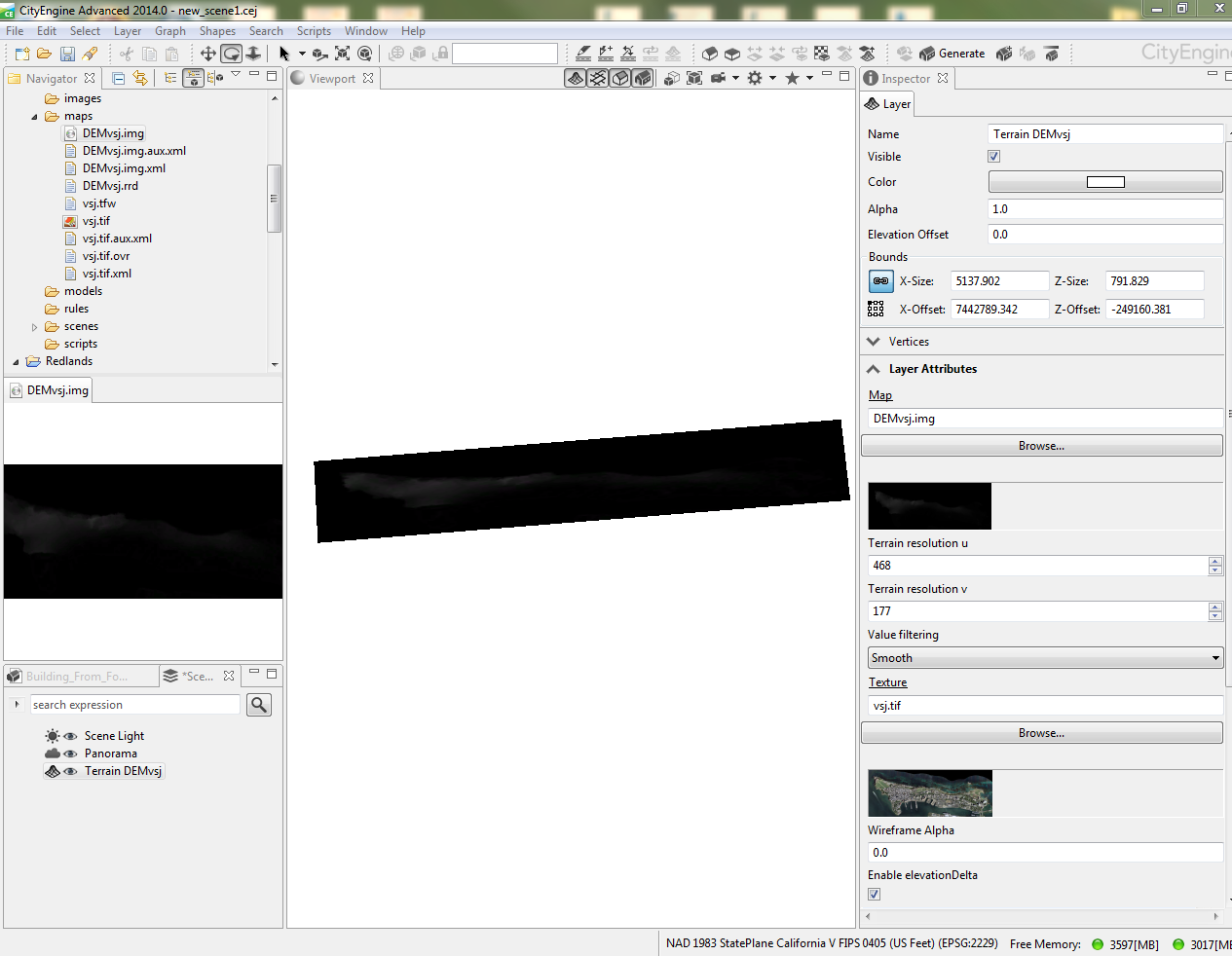 https://www.dropbox.com/s/h7ho8t2uzl3v6hr/CALLES.shp.zip?dl=0
Here you can find my data, it seem correct, I can see it perfectly in ArcMap but when I try to see it as it suppouse in City Engine, I just see black.
Could you help me!
thanks
DLL