- Home
- :
- All Communities
- :
- Products
- :
- ArcGIS CityEngine
- :
- ArcGIS CityEngine Questions
- :
- Bi-directional shape/attribute communication
- Subscribe to RSS Feed
- Mark Topic as New
- Mark Topic as Read
- Float this Topic for Current User
- Bookmark
- Subscribe
- Mute
- Printer Friendly Page
Bi-directional shape/attribute communication
- Mark as New
- Bookmark
- Subscribe
- Mute
- Subscribe to RSS Feed
- Permalink
Hi folks,
An interesting by-product of my little experiments from this thread ... thanks Cheryl !
Minimum distance based on axis / world orientation ?
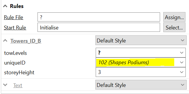
With a bit of hacking I managed to get different shapes and rules to talk to each other (passing level numbers in this case) with just a single Attribute Connection Link - shapeID.
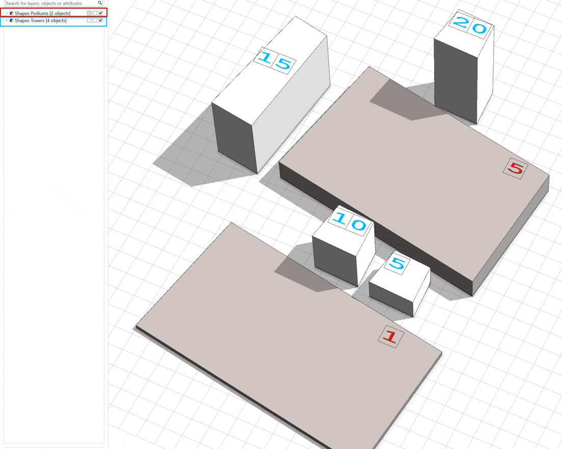
This is just a simple proof of concept where;
- Initial slide (everything separate) shows each podium's and tower's number of levels.
- Podiums (red text) report on total number of levels - itself plus all towers placed on top of it.
- Towers (blue text) report on total number of levels - themselves plus all towers placed on top of the same common podium.
So essentially podiums communicate one of their attributes to the towers, and towers communicate one of their attributes to the podiums.
Podiums and Towers have different rule files applied, with only a single Connect Attribute link applied to both - a unique shapeID. They are not linked in any other way nor do they share common attribute names etc.
It's all handled via occlusion queries.
- Mark as New
- Bookmark
- Subscribe
- Mute
- Subscribe to RSS Feed
- Permalink
This is one of the greatest things I have gotten to see in a while in a CGA thread. Regional (contextual) information being made locally available and relevant to the smaller parts. Can you share the code for this somewhere? Just this sample?
The planning implications of this are immense. You could in theory create dynamic land use mix entropy indexes. What a time to be alive...
- Mark as New
- Bookmark
- Subscribe
- Mute
- Subscribe to RSS Feed
- Permalink
Heya David,
I'm so glad you like/ appreciate this.
For a second there I thought that maybe I created something that's easily achieved in other ways in CE 
It's a little clunky, but let me just clean it up and comment things and then it's all yours.
With a small addition from Esri to occlusion queries (not sure if it's possible however) this could be way more efficient, neater and easier to manage. For us it was to enable simple communication between podiums and towers, and to report on the building (with separate shapes and rule files) as a whole. I'm sure you'll think of way more interesting things to do with this.
- Mark as New
- Bookmark
- Subscribe
- Mute
- Subscribe to RSS Feed
- Permalink
Please share. I just want to take a look. I am curious if something could be done in a similar way with the minimum distance functions.
- Mark as New
- Bookmark
- Subscribe
- Mute
- Subscribe to RSS Feed
- Permalink
Hi Alan - I second David's comments: this is really neat! Were you able to share the code example, and would you share again...?
Thanks!
- Mark as New
- Bookmark
- Subscribe
- Mute
- Subscribe to RSS Feed
- Permalink
Hi Tim,
Glad you like it. It's still very much a hack but a good and useful one
I have an intense week or two coming up but I'll see if I can shoot you something across after that.
Cheers.
- Mark as New
- Bookmark
- Subscribe
- Mute
- Subscribe to RSS Feed
- Permalink
Thanks! And, no rush - appreciate the sharing.