- Home
- :
- All Communities
- :
- Products
- :
- ArcGIS AppStudio
- :
- ArcGIS AppStudio Questions
- :
- Re: Offline mmpk Map Not Displaying
- Subscribe to RSS Feed
- Mark Topic as New
- Mark Topic as Read
- Float this Topic for Current User
- Bookmark
- Subscribe
- Mute
- Printer Friendly Page
Offline mmpk Map Not Displaying
- Mark as New
- Bookmark
- Subscribe
- Mute
- Subscribe to RSS Feed
- Permalink
Hello
I have posted this issue a couple of times, but this is the only step that will not allow me to deploy the app to the willing and waiting public.
I cannot for the life of me get the offline map to work.
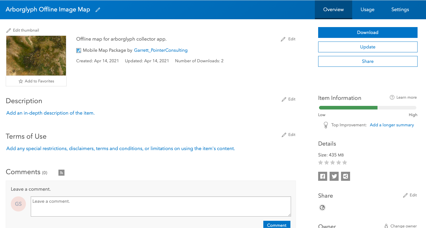
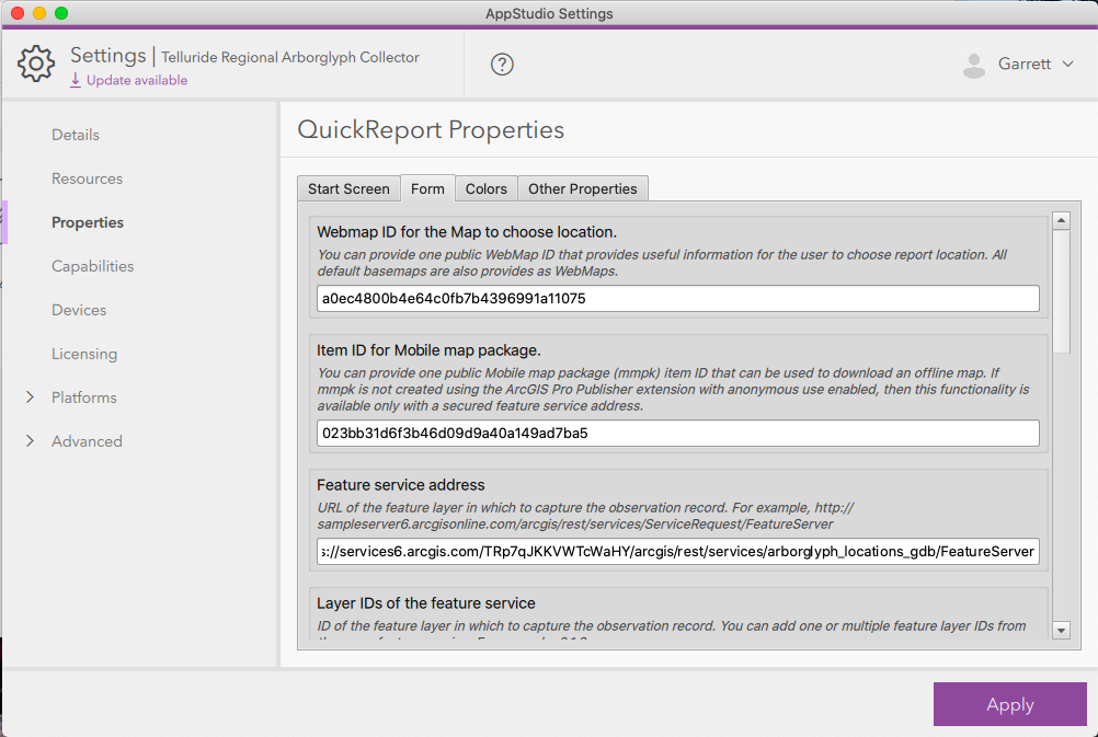
I created the mmpk with ArcPro. Uploaded it to my ArcGIS Online account. And I think that I am referencing it right in my settings. (Pictures attached).
Could the file be corrupted? Is there something obvious that I am missing?
Thanks for any help, this app is soon ready for prime time and it has been a really long but rewarding process.
G
- Mark as New
- Bookmark
- Subscribe
- Mute
- Subscribe to RSS Feed
- Permalink
I noticed your MMPK has an image in it. Is this a tile package or raster? If a raster, there are additional license requirements (not sure if you are aware of it).
- Mark as New
- Bookmark
- Subscribe
- Mute
- Subscribe to RSS Feed
- Permalink
Hi
This is a raster. I was unaware that there were additional license requirements. Is this specific to AppStudio? I have developed a number of Survey123 surveys using mmpk raster files with no issue.
Is there a place to learn about these requirements or should I try a tile package?
Thank you so much for the response and hopefully followup so I can learn more about this.
G
- Mark as New
- Bookmark
- Subscribe
- Mute
- Subscribe to RSS Feed
- Permalink
Hi Garret
I would definitely recommend that you convert your raster to a tile package to avoid the licensing headaches. I had to do so some time back.
When you sign in with a named user account, like into Survey123, a named user account does serve as the equivalent to a standard runtime license (unlocking more benefits, such as editing - and rasters it seems). Do check out the below links for more info on licensing.
https://developers.arcgis.com/net/license-and-deployment/license/
https://developers.arcgis.com/net/license-and-deployment/license/
Cheers
Mervyn
- Mark as New
- Bookmark
- Subscribe
- Mute
- Subscribe to RSS Feed
- Permalink
Hello
I changed the raster to a tile and then packaged it as an mmpk.
When I uploaded it to ArcGIS Online it looks like everything is going alright until I go offline with the app. (offlineimagemap)
Here is what I am experiencing now.
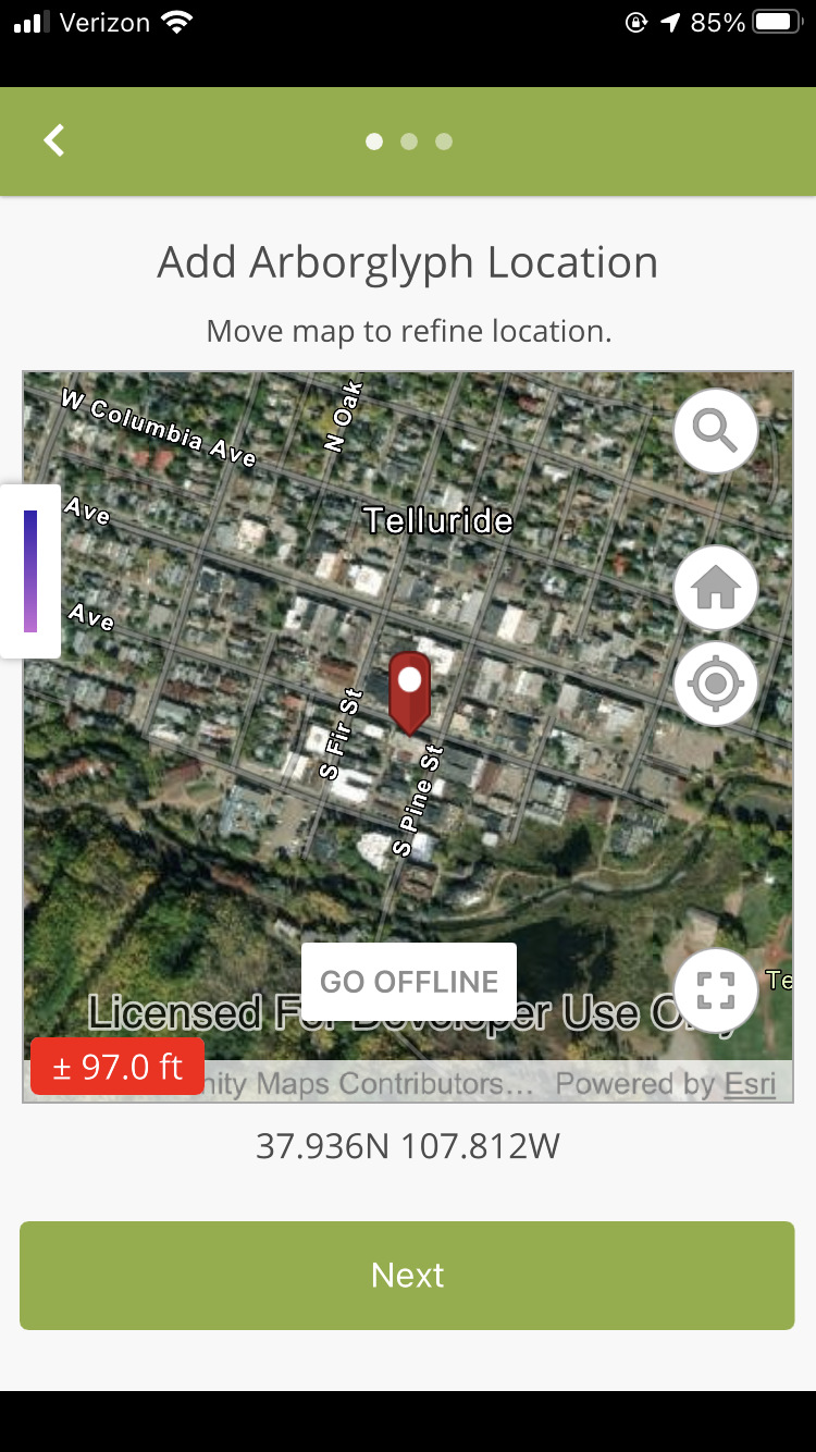
- If I open the app with cell/wifi service at my house everything looks good and I am presented with a "GO OFFLINE" button. (goofflinebutton)
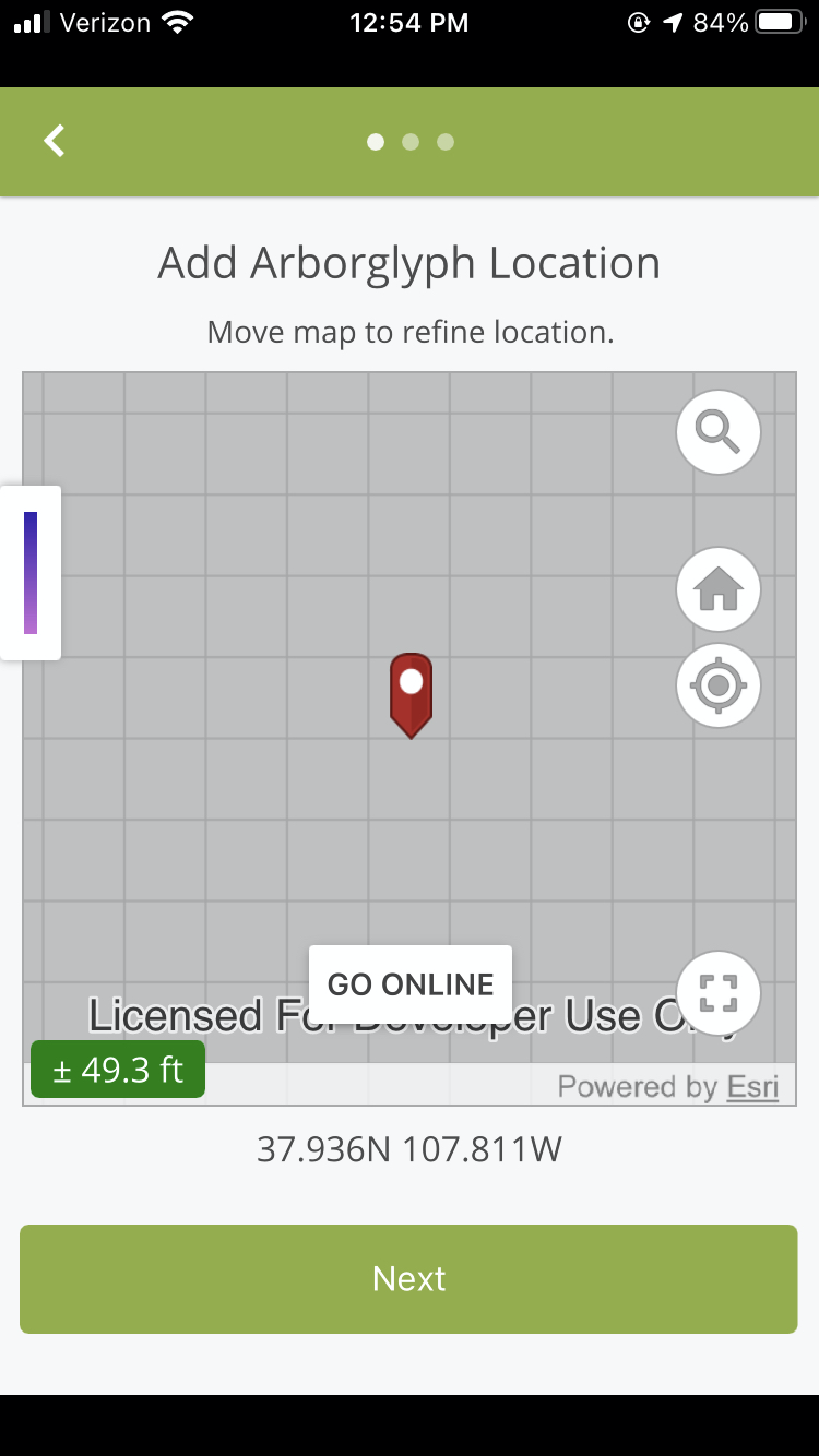
- If I press the "GO OFFLINE" button I get a blank map screen with grids, but I do see a lat and long so it is capturing my location, however I am not sure how this is offline? (offlinebutton)
- If I switch my phone to "Airport" mode while I have the map open and come back into the app I am able to view the map and I have lat and long measures because I guess it was previously loaded while I was not in Airport mode? (airpohrtmode)
- If I switch my phone to "Airport" mode while I am not using the app, in this case ESRI's AppStudio Player (for testing), and log-in to the app, I get the "No Map Available" message and no lat and long location data. (nomapavailable)
Do you have to also put the mmpk file in the app's folders so that it will side load like Survey123 does when the app is uploaded to a person's phone?
Thank you for any wisdom that you might have related to this issue. I am struggling but almost done with this project so that is a good thing. Unfortunately about 80% of the project area does not have reliable cell phone service, so I really have to work this out.
- Mark as New
- Bookmark
- Subscribe
- Mute
- Subscribe to RSS Feed
- Permalink
I dont know what is happening with your app and I hope someone else can offer some wisdom.
The problem seems to be with your "GO OFFLINE" button and code. If you are already including an offline TPK in your MMPK with your app (it is large at 435 MB so I presume you you have a detailed TPK included with app), why have an option to take map offline when you can just do so from the start? Just follow the instructions (code) from the Open Mobile Map (mmpk) sample app and place your MMPK in the app's Data folder. This would possibly simplify your process but note that I really know very little about your app so my suggestions may be way off.
- Mark as New
- Bookmark
- Subscribe
- Mute
- Subscribe to RSS Feed
- Permalink
Hi
Thanks so much.
It is a large study area, 50-mile radius from our town, so that is shy the mmpk is large.
I to have no idea what is going on. This is my first journey into the world of AppStudio as I usually use Survey123 or Collector (now Field Maps) for a project like this. I am by no means a coder and this is probably really noticeable in all my questions this board. I thought AppStudio was much more plug and play, but now I understand why app development is such a growing field.
I am using the QuickReport template and have not changed anything as far as the code for the offline map goes. I have tinkered here and there with some of the functionality but know that I have not touched anything related to mmpks.
Maybe someone else that has used the QuickReport template with offline maps successfully can weigh in? I feel like I am so close to getting this wrapped up and then I can go back to the world of field data collection that I understand.
- Mark as New
- Bookmark
- Subscribe
- Mute
- Subscribe to RSS Feed
- Permalink
I feel your pain, been there myself (still am there I think). I know more about MMPKs than AppStudio.
I have used the Map Viewer template a few times. I had a quick look at Quick Report template and it functions very similarly.
Have you created a MMPK with your TPK as basemap and created it with the Publisher extension? If so, then upload this separately from your app to AGOL and then share with public (if that is what you need). Once that is done, copy the item ID for your MMPK from AGOL and paste that into the Quick Report Properties > Form tab > Item ID for Mobile Map Package space holder. You dont need to include it with your app when you upload your app, it is a separate process. Then when you click on Go OFFLINE, then the app will automatically download the MMPK from AGOL based on the item ID you provided. You should see an indicator turning as you wait for teh download. I quickly tested this and it works as expected.
Why is your app so large? It should be a small upload. How have you tried to include the MMPK in the Quick Report template?
- Mark as New
- Bookmark
- Subscribe
- Mute
- Subscribe to RSS Feed
- Permalink
Hi
I did create the mmpk with the tpk as the baseman. I assume that I used the Publisher extension? I did it in ArcGIS Pro (I am used to working the ArcMap, but it seemed like Pro was what everyone uses for mmpks).
I did all the other things that you are talking about with AGOL and linked it through the QuickReport Properties (attached).
The offline button will actually bring me to an offline setting eventually after spinning for a bit. However, there is no map displayed (attached).
Is this normal with AppStudio that someone would have to download the mmpk before they went offline? What happens if they are out in the field without being attached to a network and then try to work offline? I would assume that the app would not work since it was never switched to "offline" mode via the button. If that is true, this does not seem to be a good solution for my field data collection project. Just some thoughts, but you probably have way more experience than I do with this software.
Thanks and again, please let me know if anything obvious sticks out here.
- Mark as New
- Bookmark
- Subscribe
- Mute
- Subscribe to RSS Feed
- Permalink
So if you want to share your MMPK with the public, then you need the Publisher extension. If you have the Publisher extension, then when you are in Pro you will be provided with the option to "Enable Anonymous Use", which you must take. If you don't see that option then you don't have the extension. If that is the case then users will need to sign into the app with a named user account.
Another reason your MMPK may not be showing is because your TPK is in a different projection to that of your feature layers and map. It is best to use the WGS 1984 Web Mercator projection for map and TPK to avoid any incompatibility issues. You can use other projections if need be but the map and TPK need to be in same projection, but I have occasionally seen problems arise with custom projections.
The workflow you described is normal in that people first need to download the map before going into an area without coverage. But once it is offline, they wont have to do so again.
Do check out the TPK projection and Publisher extension, but if that is not the cause, do check out the Map Viewer template. As of AppStudio Version 5, you can now also edit features in this app.