- Home
- :
- All Communities
- :
- Products
- :
- ArcGIS AppStudio
- :
- ArcGIS AppStudio Questions
- :
- Re: map package / basemaps
- Subscribe to RSS Feed
- Mark Topic as New
- Mark Topic as Read
- Float this Topic for Current User
- Bookmark
- Subscribe
- Mute
- Printer Friendly Page
map package / basemaps
- Mark as New
- Bookmark
- Subscribe
- Mute
- Subscribe to RSS Feed
- Permalink
I have a QuickReport 3.3 up and running...everything is working fine but now looking to figure out how to get may own basemaps loaded so I can work in a disconnected environment.
Dont know if this is possible but I want to be able to bring some aerials and a parcel layer that I can identify on. Is this possible? If not just getting a basemap local would be beneficial.
With that said what are my options? Map Package? Other?
- Mark as New
- Bookmark
- Subscribe
- Mute
- Subscribe to RSS Feed
- Permalink
My Data was in UTM Zone 17N, So was the map
When I created the TPK file is converted it to WGS 84 Web Mercator Aux Sphere for some reason
Pretty confused right now...
Why is if changing the coordinate system to WGS84?
Should I just project my data to WGS84 and try again?
I have a simply counties layer with just an orange line
I have a tif file that was exported from a .sid file into a raster.
No errors on Map Package creation
- Mark as New
- Bookmark
- Subscribe
- Mute
- Subscribe to RSS Feed
- Permalink
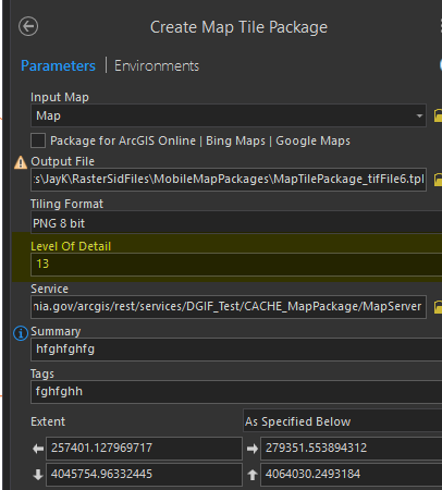
For the Tile Package I unchecked the "Package for ArcGIS ONline|Bing Maps|Google Maps"
I pointed to a simple service i have with a few cached levels.
Does this have to match the "Level of Detail" when I create the Map Tile Package?
- Mark as New
- Bookmark
- Subscribe
- Mute
- Subscribe to RSS Feed
- Permalink
THINK I GOT IT.....ONE more round of testing.
- « Previous
-
- 1
- 2
- Next »
- « Previous
-
- 1
- 2
- Next »