- Home
- :
- All Communities
- :
- Products
- :
- ArcGIS AppStudio
- :
- ArcGIS AppStudio Questions
- :
- map package / basemaps
- Subscribe to RSS Feed
- Mark Topic as New
- Mark Topic as Read
- Float this Topic for Current User
- Bookmark
- Subscribe
- Mute
- Printer Friendly Page
map package / basemaps
- Mark as New
- Bookmark
- Subscribe
- Mute
- Subscribe to RSS Feed
- Permalink
I have a QuickReport 3.3 up and running...everything is working fine but now looking to figure out how to get may own basemaps loaded so I can work in a disconnected environment.
Dont know if this is possible but I want to be able to bring some aerials and a parcel layer that I can identify on. Is this possible? If not just getting a basemap local would be beneficial.
With that said what are my options? Map Package? Other?
- Mark as New
- Bookmark
- Subscribe
- Mute
- Subscribe to RSS Feed
- Permalink
Hi Jay,
Thank you for asking your question in GeoNet community.
Yes, the Quick Report template supports public offline Mobile Map Package (MMPK) created using ArcGIS Pro Publisher extension with anonymous use enabled.
You can refer to this documentation or this blog post to create an offline mobile map package.
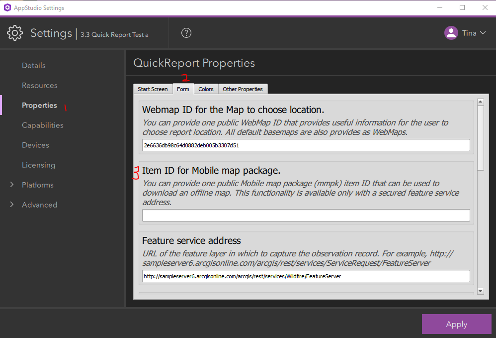
After MMPK was created and published. You can enter your MMPK item ID in the Settings > Form > Item ID for Mobile map package filed (see screenshot below) > Apply.
I hope this will help you!
Thanks,
Tina
- Mark as New
- Bookmark
- Subscribe
- Mute
- Subscribe to RSS Feed
- Permalink
Do I have this correctly. Using the Quick Report 3.3
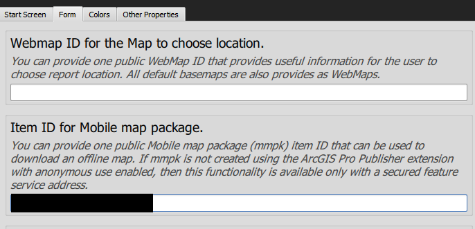
If you specify a WebMap ID the application will use that when connected to cellular service
If you loose connectivity it will revert to a map package the you specify in number 3 from your image above
Do you have to download it first? Can you preload it? Can you simply use only the map package?
- Mark as New
- Bookmark
- Subscribe
- Mute
- Subscribe to RSS Feed
- Permalink
Hi Jay.
If you provide a public offline Mobile Map Package (MMPK) created using ArcGIS Pro Publisher extension with anonymous use enabled. You will see a "GO OFFLINE" button in the Map Page (see screenshot below), the first time you tapping on the "GO OFFLINE" button, it will download the MMPK, and next time you tap on this button, It will show the MMPK.
You can choose to view MMPK/ web map by simply tap on "GO OFFLINE" and "GO ONLINE" button.

Here is a public MMPK "3453c82cf36149faa3e609e0dcbc3b95" that you can use to try the offline feature to see if it fits your request.
Thanks,
Tina
- Mark as New
- Bookmark
- Subscribe
- Mute
- Subscribe to RSS Feed
- Permalink
Great...OK that is a bit clearer right now....
Can I create a mobile package with ESRIs Basemap aerials?
We have aerials - Can I create one from SID files? TIFF Files? Trying to find the best way to get aerial images along with some parcel data into a map package that users can download?
Would I create a mosaic from my data first then create the map package?
Can I use a Tile Package in the same way?
Any thoughts or suggestions?
- Mark as New
- Bookmark
- Subscribe
- Mute
- Subscribe to RSS Feed
- Permalink
I took a SID file and a Vector Border file...
In ArcGIS Pro I added them to a project and then "Create Mobile Map Package"
I uploaded it to my Developer ArcGIS Online and shared with everyone.
I grabbed numbers at the end of the URL when its active in AGOL
I add them to the "Item ID for Mobile Map package"
But when I go into the app it does not give me the Offline button
But your MMPK worked for me....what did I do wrong
Do I eed to Create a .TPK or VTPK file first and then use that in from the Create Mobile Map Package?
- Mark as New
- Bookmark
- Subscribe
- Mute
- Subscribe to RSS Feed
- Permalink
Hi Jay,
1. I don't think you can directly use ESRI online basemap aerials.
2. You can convert your tile package into an MMPK in ArcGIS Pro (See Mark's blog post to learn more).
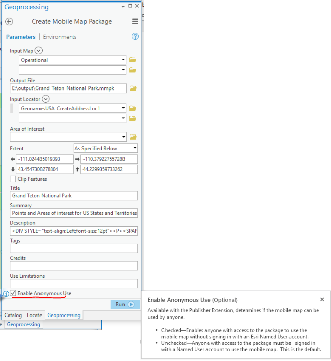
3. Your Mobile Map Package (MMPK) has to be created using ArcGIS Pro Publisher extension with anonymous use enabled (See screenshot below). ( Also see Mark's blog post part 2 to learn more)
Thanks,
Tina
- Mark as New
- Bookmark
- Subscribe
- Mute
- Subscribe to RSS Feed
- Permalink
OK I made sure I was signed in to Pro and had the publisher extension enabled....reason why I did not see the Chek box at the bottom.
I created the map Package and uploaded it to my Dev AGOL
I can now see it.
I add this to my AppStudio project but still cannot see it in my app
I can navigate to where the MMPK was downloaded to my phone but cant see it in the map
Does this have to be a specific projection?
- Mark as New
- Bookmark
- Subscribe
- Mute
- Subscribe to RSS Feed
- Permalink
OK I create one with just one county outline and it worked....
Is there a size limit? Is there a spatial coverage size....like 30 county boundaries worth?
- Mark as New
- Bookmark
- Subscribe
- Mute
- Subscribe to RSS Feed
- Permalink
Jay,
There is not a defined size limit, its really the available storage on device that is the limit, a 100 GB mmpk is not unheard of...
What type of content is not showing up for you?
It is possible to put content or use cartography in a mobile map package that is not supported for display by the particular application or version of ArcGIS Runtime that is being used.
Tile Packages (TPK) should work for displaying aerial imagery in most applications.
Also, reading up the comments in this post...
It is best to have all content in the same coordinate system. The runtime will not project TPK or VTPK layers on the fly, the coordinate system of the map and the Tile Package and Vector Tile Package layers must match.
mark