- Home
- :
- All Communities
- :
- Developers
- :
- ArcGIS API for Python
- :
- ArcGIS API for Python Questions
- :
- python script not working
- Subscribe to RSS Feed
- Mark Topic as New
- Mark Topic as Read
- Float this Topic for Current User
- Bookmark
- Subscribe
- Mute
- Printer Friendly Page
python script not working
- Mark as New
- Bookmark
- Subscribe
- Mute
- Subscribe to RSS Feed
- Permalink
I am trying to find out why the python script that I wrote isnt working. I am trying to count the number of stairs in a stairwell. I have two shapefiles and i wrote the script to run auto and process how many stairs there are. if someone can help me with this I would appreciate it thanks.
- Mark as New
- Bookmark
- Subscribe
- Mute
- Subscribe to RSS Feed
- Permalink
Sharing with Python since this looks to be ArcPy and not ArcGIS API for Python.
Please paste the code (not a screenshot) and use /blogs/dan_patterson/2016/08/14/script-formatting?sr=search&searchId=bdf45239-640f-4c59-b3e5-bbc4c8d.... Also, provide the error and traceback if you are getting an error. If you are seeing unexpected results, describe what you are seeing and what you expect.
- Mark as New
- Bookmark
- Subscribe
- Mute
- Subscribe to RSS Feed
- Permalink
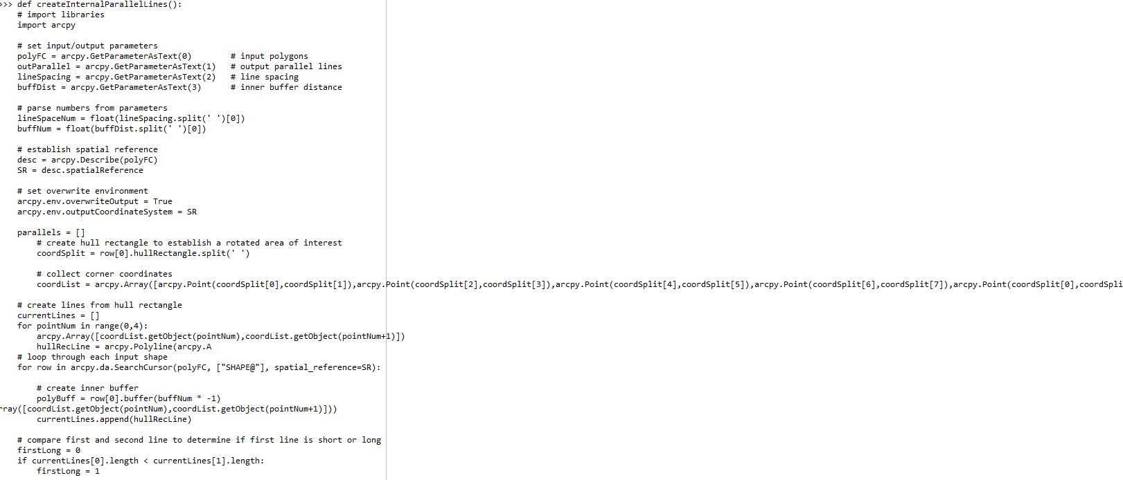
here is the code below. again im not too familar with python so i am asking for some help
def createInternalParallelLines():
# import libraries
import arcpy
# set input/output parameters
polyFC = arcpy.GetParameterAsText(0) # input polygons
outParallel = arcpy.GetParameterAsText(1) # output parallel lines
lineSpacing = arcpy.GetParameterAsText(2) # line spacing
buffDist = arcpy.GetParameterAsText(3) # inner buffer distance
# parse numbers from parameters
lineSpaceNum = float(lineSpacing.split(' ')[0])
buffNum = float(buffDist.split(' ')[0])
# establish spatial reference
desc = arcpy.Describe(polyFC)
SR = desc.spatialReference
# set overwrite environment
arcpy.env.overwriteOutput = True
arcpy.env.outputCoordinateSystem = SR
parallels = []
# create hull rectangle to establish a rotated area of interest
coordSplit = row[0].hullRectangle.split(' ')
# collect corner coordinates
coordList = arcpy.Array([arcpy.Point(coordSplit[0],coordSplit[1]),arcpy.Point(coordSplit[2],coordSplit[3]),arcpy.Point(coordSplit[4],coordSplit[5]),arcpy.Point(coordSplit[6],coordSplit[7]),arcpy.Point(coordSplit[0],coordSplit[1])])
# create lines from hull rectangle
currentLines = []
for pointNum in range(0,4):
arcpy.Array([coordList.getObject(pointNum),coordList.getObject(pointNum+1)])
hullRecLine = arcpy.Polyline(arcpy.A
# loop through each input shape
for row in arcpy.da.SearchCursor(polyFC, ["SHAPE@"], spatial_reference=SR):
# create inner buffer
polyBuff = row[0].buffer(buffNum * -1)
rray([coordList.getObject(pointNum),coordList.getObject(pointNum+1)]))
currentLines.append(hullRecLine)
# compare first and second line to determine if first line is short or long
firstLong = 0
if currentLines[0].length < currentLines[1].length:
firstLong = 1
# calculate number of points needed along short axis
numPoints = int(math.floor(currentLines[firstLong].length/lineSpaceNum))
# create and join points to create parallel lines
for point in range(1,numPoints+1):
shortPoint1 = currentLines[firstLong].positionAlongLine(lineSpaceNum*point)
shortPoint2 = currentLines[firstLong + 2].positionAlongLine(currentLines[firstLong + 2].length - (lineSpaceNum*point))
parallel = arcpy.Polyline(arcpy.Array([shortPoint1.centroid,shortPoint2.centroid]), SR)
# intersect parallel lines with buffer
parallelBuff = parallel.intersect(polyBuff,2)
parallels.append(parallelBuff)
# write geometries to disk
arcpy.CopyFeatures_management(parallels, outParallel)
# add to map
mxd = arcpy.mapping.MapDocument("CURRENT")
dataFrame = arcpy.mapping.ListDataFrames(mxd, "*")[0]
addLayer = arcpy.mapping.Layer(outParallel)
arcpy.mapping.AddLayer(dataFrame, addLayer)
del row
- Mark as New
- Bookmark
- Subscribe
- Mute
- Subscribe to RSS Feed
- Permalink
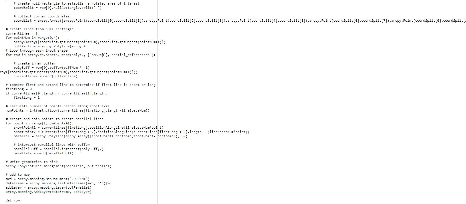
Here is the code… thanks for your help
def createInternalParallelLines():
import libraries
import arcpy
set input/output parameters
polyFC = arcpy.GetParameterAsText(0) # input polygons
outParallel = arcpy.GetParameterAsText(1) # output parallel lines
lineSpacing = arcpy.GetParameterAsText(2) # line spacing
buffDist = arcpy.GetParameterAsText(3) # inner buffer distance
parse numbers from parameters
lineSpaceNum = float(lineSpacing.split(' ')[0])
buffNum = float(buffDist.split(' ')[0])
establish spatial reference
desc = arcpy.Describe(polyFC)
SR = desc.spatialReference
set overwrite environment
arcpy.env.overwriteOutput = True
arcpy.env.outputCoordinateSystem = SR
parallels = []
create hull rectangle to establish a rotated area of interest
coordSplit = row[0].hullRectangle.split(' ')
collect corner coordinates
coordList = arcpy.Array([arcpy.Point(coordSplit[0],coordSplit[1]),arcpy.Point(coordSplit[2],coordSplit[3]),arcpy.Point(coordSplit[4],coordSplit[5]),arcpy.Point(coordSplit[6],coordSplit[7]),arcpy.Point(coordSplit[0],coordSplit[1])])
create lines from hull rectangle
currentLines = []
for pointNum in range(0,4):
arcpy.Array()
hullRecLine = arcpy.Polyline(arcpy.A
loop through each input shape
for row in arcpy.da.SearchCursor(polyFC, ["SHAPE@"], spatial_reference=SR):
create inner buffer
polyBuff = row[0].buffer(buffNum * -1)
rray())
currentLines.append(hullRecLine)
compare first and second line to determine if first line is short or long
firstLong = 0
if currentLines[0].length < currentLines[1].length:
firstLong = 1
calculate number of points needed along short axis
numPoints = int(math.floor(currentLines[firstLong].length/lineSpaceNum))
create and join points to create parallel lines
for point in range(1,numPoints+1):
shortPoint1 = currentLines[firstLong].positionAlongLine(lineSpaceNum*point)
shortPoint2 = currentLines[firstLong + 2].positionAlongLine(currentLines[firstLong + 2].length - (lineSpaceNum*point))
parallel = arcpy.Polyline(arcpy.Array(), SR)
intersect parallel lines with buffer
parallelBuff = parallel.intersect(polyBuff,2)
parallels.append(parallelBuff)
write geometries to disk
arcpy.CopyFeatures_management(parallels, outParallel)
add to map
mxd = arcpy.mapping.MapDocument("CURRENT")
dataFrame = arcpy.mapping.ListDataFrames(mxd, "*")[0]
addLayer = arcpy.mapping.Layer(outParallel)
arcpy.mapping.AddLayer(dataFrame, addLayer)
del row
- Mark as New
- Bookmark
- Subscribe
- Mute
- Subscribe to RSS Feed
- Permalink
Follow your other post
https://community.esri.com/thread/222977-arcpy-scripting-error-question
and use the code formatting link in there.
There are other unaddressed questions as well.