- Home
- :
- All Communities
- :
- Developers
- :
- ArcGIS API for Python
- :
- ArcGIS API for Python Questions
- :
- Re: Buffer geocoded Address
- Subscribe to RSS Feed
- Mark Topic as New
- Mark Topic as Read
- Float this Topic for Current User
- Bookmark
- Subscribe
- Mute
- Printer Friendly Page
- Mark as New
- Bookmark
- Subscribe
- Mute
- Subscribe to RSS Feed
- Permalink
Hello,
I am using Python API to geocode a list of address, then buffer the geocoded address by 1 mile, what I have so far:
addlist=['adress1',
'address2',
'address3']
bgeocode=batch_geocode(addlist)
for address in bgeocode:
poly=buffer(geometries=[Geometry(address['location'])],in_sr=3857,
distances=[1],unit='Miles')[0]
m1.draw(poly)
The result:
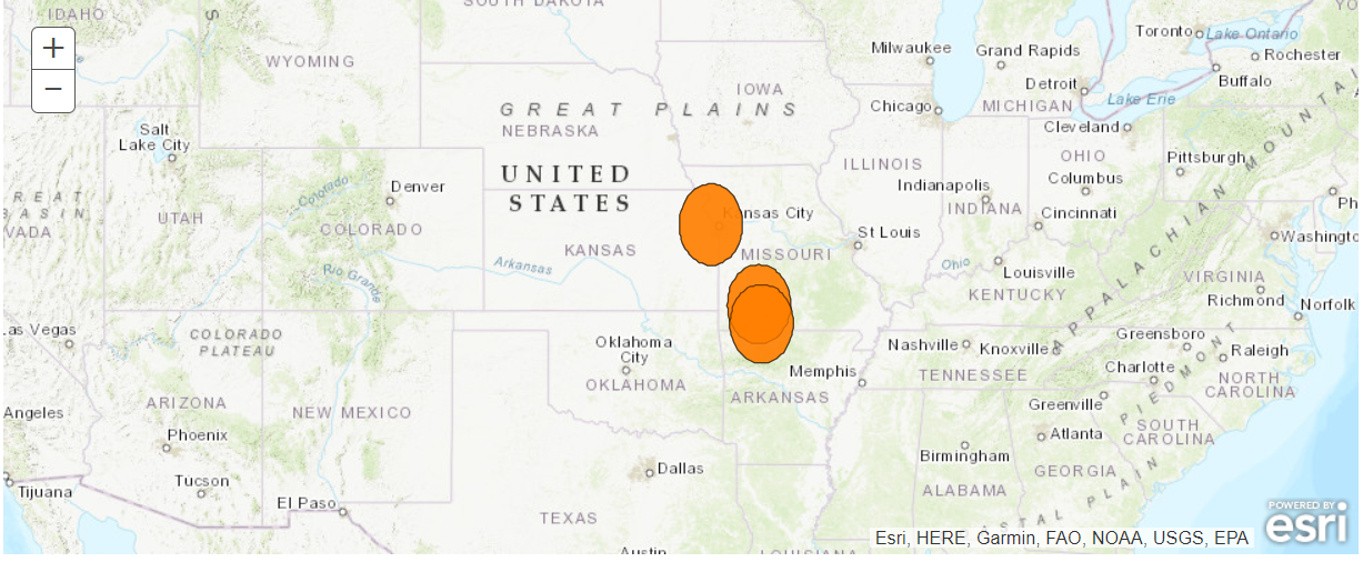
Now my question is why the result buffer looks like an ellipse not a circle? also, the circles are more than 1 mile ? is there another method to buffer the address and show them on the map, because here I am using the buffer for each address?
Thank you,
Ahmad
Solved! Go to Solution.
Accepted Solutions
- Mark as New
- Bookmark
- Subscribe
- Mute
- Subscribe to RSS Feed
- Permalink
The buffer function is a bit confusing and clunky, here is what I mean:
When you specify the in_sr value, the unit parameter is not relevant any more. for example, if you specify in_sr=4326, the unit will be "degree" regardless whatever value you specify for the unit parameter. if you set in_sr=3857, the input values will be "Meters".
In regard to which projection to choose, for a 1 Mile radius circle, you should not see big difference between SRID 3857 and a relative accurate local projection --- the distortion caused by projection become more visible over long distances or large areas.
I would recommend to use use_proximity.create_buffers() for your task.
addresses = ['Adelaide, South Australia',
'Mount Barker, South Australia',
'Brookside St, Oakden,South Australia']
results = batch_geocode(addresses)
fs=[Feature(geometry=Geometry(res['location'])) for res in results]
fset = FeatureSet(fs)
sms = {
"color": [255,0,0,150],
"size": 10,
"angle": 0,
"xoffset": 0,
"yoffset": 0,
"type": "simple-marker",
"outline": {
"color": [
255,
255,
255,
255
],
"width": 1,
"type": "esriSLS",
"style": "esriSLSSolid"
}
}
for res in results:
map1.draw(res['location'],symbol=sms)
prox=use_proximity.create_buffers(fset.to_dict(),distances=[1],units='Miles')
map1.add_layer(prox)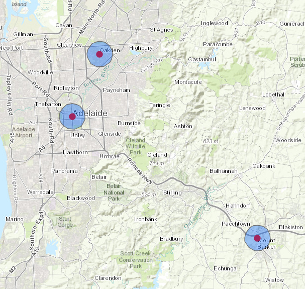
- Mark as New
- Bookmark
- Subscribe
- Mute
- Subscribe to RSS Feed
- Permalink
This looks like an issue related to wrong map projection.
The World Geocoding Service spatial reference is 4326 (a.k.a WGS84)
So try this if you want to use SRID 3857 (same as ESRI 102100):
bgeocode=batch_geocode(addlist,out_sr=3857)- Mark as New
- Bookmark
- Subscribe
- Mute
- Subscribe to RSS Feed
- Permalink
Those buffers are also in the units of the data... and certainly are not 1 mile.
And any web projection isn't really good for distance or direction (especially web Mercator and its ilk), so if that is most important try something like https://epsg.io/5070 which is think is used in the U.S.
Melita Kennedy... sorry, could you check my suggestion for this webby world
- Mark as New
- Bookmark
- Subscribe
- Mute
- Subscribe to RSS Feed
- Permalink
I assume the center of the buffers are in the correct locations? If certainly looks like the buffer distance was treated as 1 degree, rather than 1 mile. Projected into Web Mercator (EPSG:3857), the north-south distance would get stretched because that's what Mercator does to maintain conformality (local angles/shapes).
Maybe try something like:
buffer(geometries=[Geometry(address['location'])],in_sr=4326,distances=[1],unit='Miles',out_sr=3857,buffer_sr=4326,geodesic=true)
- Mark as New
- Bookmark
- Subscribe
- Mute
- Subscribe to RSS Feed
- Permalink
The buffer function is a bit confusing and clunky, here is what I mean:
When you specify the in_sr value, the unit parameter is not relevant any more. for example, if you specify in_sr=4326, the unit will be "degree" regardless whatever value you specify for the unit parameter. if you set in_sr=3857, the input values will be "Meters".
In regard to which projection to choose, for a 1 Mile radius circle, you should not see big difference between SRID 3857 and a relative accurate local projection --- the distortion caused by projection become more visible over long distances or large areas.
I would recommend to use use_proximity.create_buffers() for your task.
addresses = ['Adelaide, South Australia',
'Mount Barker, South Australia',
'Brookside St, Oakden,South Australia']
results = batch_geocode(addresses)
fs=[Feature(geometry=Geometry(res['location'])) for res in results]
fset = FeatureSet(fs)
sms = {
"color": [255,0,0,150],
"size": 10,
"angle": 0,
"xoffset": 0,
"yoffset": 0,
"type": "simple-marker",
"outline": {
"color": [
255,
255,
255,
255
],
"width": 1,
"type": "esriSLS",
"style": "esriSLSSolid"
}
}
for res in results:
map1.draw(res['location'],symbol=sms)
prox=use_proximity.create_buffers(fset.to_dict(),distances=[1],units='Miles')
map1.add_layer(prox)
- Mark as New
- Bookmark
- Subscribe
- Mute
- Subscribe to RSS Feed
- Permalink
Thank you All, it was really tricky, but Simo's method did the job perfectly.