- Home
- :
- All Communities
- :
- Developers
- :
- ArcGIS API for Python
- :
- ArcGIS API for Python Questions
- :
- Re: Add a polygon to a Spatially Enabled Dataframe
- Subscribe to RSS Feed
- Mark Topic as New
- Mark Topic as Read
- Float this Topic for Current User
- Bookmark
- Subscribe
- Mute
- Printer Friendly Page
Add a polygon to a Spatially Enabled Dataframe
- Mark as New
- Bookmark
- Subscribe
- Mute
- Subscribe to RSS Feed
- Permalink
Hi,
Sorry if this is a basic question but I can't seem to crack it. I am creating a Polygon feature from a list of xy values and want to add it to a Spatially Enabled Dataframe. How could I make a SEDF that holds the following polygon?
import pandas as pd from arcgis.geometry import Polygon from arcgis.features import SpatialDataFrame shape = { "rings": [[[-90.0, 30.0], [-91.0, 30.0], [-90.0, 31.0]]], "spatialreference" : {"wkid" : 4326}} polygonFeature = Polygon(shape) print(polygonFeature.is_valid) df = pd.DataFrame()
The polygon created from the values is valid, I'm just not sure how I could add it to an SEDF and then append additional polygons.
Thanks for any help!
Solved! Go to Solution.
Accepted Solutions
- Mark as New
- Bookmark
- Subscribe
- Mute
- Subscribe to RSS Feed
- Permalink
Hi Matthew Thompson,
You can use the following code to create a spatial dataframe from the shape:
from arcgis import GIS
from arcgis.features import SpatialDataFrame, Feature, FeatureSet
import pandas as pd
from arcgis import geometry
shape = {
"rings": [[[-90.0, 30.0], [-91.0, 30.0], [-90.0, 31.0]]],
"spatialreference" : {"wkid" : 4326}}
polygonFeature = Polygon(shape)
polygon_new = Feature(geometry=polygonFeature, attributes={"title": "Polygon test",
"description": "This is a test",})
#Create a featureset to access spatial dataframe
polygon_fset = FeatureSet(features = [polygon_new],
geometry_type="Polygon",
spatial_reference={'latestWkid': 4326, 'wkid': 102100})
polygon_fset.sdf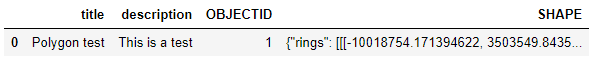
-----------------------------------------------------------------------------------------------------------------------------------------------
Please mark as helpful if you find it helpful. If it answered your question please mark it as answered.