Turn on suggestions
Auto-suggest helps you quickly narrow down your search results by suggesting possible matches as you type.
Cancel
- Home
- :
- All Communities
- :
- Developers
- :
- JavaScript Maps SDK
- :
- JavaScript Maps SDK Questions
- :
- Re: Map print incorrectly - missing segments
Options
- Subscribe to RSS Feed
- Mark Topic as New
- Mark Topic as Read
- Float this Topic for Current User
- Bookmark
- Subscribe
- Mute
- Printer Friendly Page
Map print incorrectly - missing segments
Subscribe
1129
1
07-09-2020 02:48 PM
07-09-2020
02:48 PM
- Mark as New
- Bookmark
- Subscribe
- Mute
- Subscribe to RSS Feed
- Permalink
I am using printTask to print out my map but the end result is very weird.
This is what the map should look like 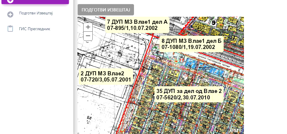
and this is what it actually looks like. It's like it's missing a layer or something

function printResult(evt) {
map = new Map("map", {
basemap: new Basemap({
layers: [new BasemapLayer({
url: 'http://10.0.0.10:6080/arcgis/rest/services/DUP_podlogi_Izvodi/MapServer'
})]
}),
extent: new Extent({
'xmin': 7530850.8094923375,
'ymin': 4647910.133863028,
'xmax': 7536270.404088697,
'ymax': 4655172.52276435,
'spatialReference': {
'wkid': 6316
}
}),
sliderStyle: 'small',
zoom: 5,
});
var secondLayer = new ArcGISDynamicMapServiceLayer("http://10.0.0.10:6080/arcgis/rest/services/Karpos_Vector_Izvodi/MapServer", {
"opacity": 1
});
map.addLayer(secondLayer);
map.on("load", selectRoute);
// code shortened for brevity
printTaskLegend = new PrintTask('http://10.0.0.10/arcgis/rest/services/Print_GISKarpos_Sync/GPServer/Export%20Web%20Map');
printPars.map = map;
var template = new PrintTemplate();
template.format = 'JPG';
template.layout = 'Print_legend_included';
template.preserveScale = true;
printPars.template = template;
printTaskLegend.execute(printPars).then(printImageLegend);
}This is my code.
1 Reply
07-10-2020
09:39 AM
- Mark as New
- Bookmark
- Subscribe
- Mute
- Subscribe to RSS Feed
- Permalink
Couple questions:
What version of the ArcGIS API for JavaScript are you using?
What is the ArcGIS Server version of the print service?
What did you use to publish the print service (ArcGIS Pro or ArcMap)?