Turn on suggestions
Auto-suggest helps you quickly narrow down your search results by suggesting possible matches as you type.
Cancel
- Home
- :
- All Communities
- :
- Products
- :
- 3D
- :
- 3D Questions
- :
- How to add the layer symbology from a raster to a ...
Options
- Subscribe to RSS Feed
- Mark Topic as New
- Mark Topic as Read
- Float this Topic for Current User
- Bookmark
- Subscribe
- Mute
- Printer Friendly Page
How to add the layer symbology from a raster to a TIN?
Subscribe
2438
3
05-23-2012 06:02 AM
05-23-2012
06:02 AM
- Mark as New
- Bookmark
- Subscribe
- Mute
- Subscribe to RSS Feed
- Permalink
Hi,
I've made a TIN in arcscene and need to change its symbology to match a salinity IDW I made. Is there a way to make the raster data "float" with the TIN. I tried using the "Add layer symbology tool" but since the TIN and Raster data aren't in the same format it won't run.
Thanks
I've made a TIN in arcscene and need to change its symbology to match a salinity IDW I made. Is there a way to make the raster data "float" with the TIN. I tried using the "Add layer symbology tool" but since the TIN and Raster data aren't in the same format it won't run.
Thanks
3 Replies
05-24-2012
03:29 AM
- Mark as New
- Bookmark
- Subscribe
- Mute
- Subscribe to RSS Feed
- Permalink
When you say 'symbology' do you mean the min/max values of the raster? Or the color ramp? The color ramps should be available to be selected, but there is not an import process from TIN to raster. In the attached screenshot, I selected 'Elevation # 1' for each TIN and raster.
[ATTACH=CONFIG]14597[/ATTACH]
If the values do not match up then the symbology will never look the same. I chose a coarse cell size for a quick export, which has contributed to the generalized look of the raster. The TIN is more angular but the symbology is similar.
[ATTACH=CONFIG]14597[/ATTACH]
If the values do not match up then the symbology will never look the same. I chose a coarse cell size for a quick export, which has contributed to the generalized look of the raster. The TIN is more angular but the symbology is similar.
05-24-2012
04:54 AM
- Mark as New
- Bookmark
- Subscribe
- Mute
- Subscribe to RSS Feed
- Permalink
Hi Jeff, thanks for your help.
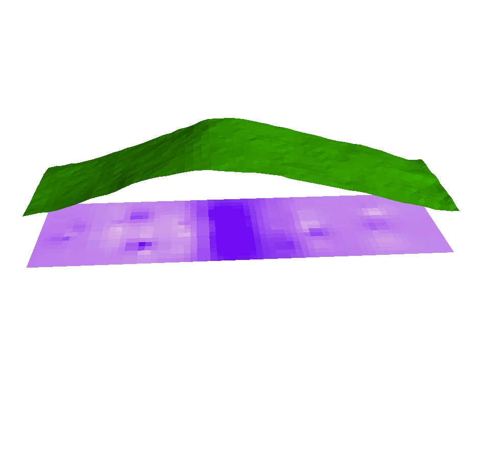
Ok, so what I have done is created a TIN from an elevation point cloud extracted from a DEM. The TIN works fine in the 3D in Arcscene. I then added the IDW I created to arcscene, which is displayed in the picture (attached) as the flattened purple raster. What I am trying to is add that purple colour (ie the values from the IDW raster) to the TIN surface so that I get a 3D view of the IDW. Is this possible? Or are there any other ways to display an IDW in 3D?
Ok, so what I have done is created a TIN from an elevation point cloud extracted from a DEM. The TIN works fine in the 3D in Arcscene. I then added the IDW I created to arcscene, which is displayed in the picture (attached) as the flattened purple raster. What I am trying to is add that purple colour (ie the values from the IDW raster) to the TIN surface so that I get a 3D view of the IDW. Is this possible? Or are there any other ways to display an IDW in 3D?
05-25-2012
03:51 AM
- Mark as New
- Bookmark
- Subscribe
- Mute
- Subscribe to RSS Feed
- Permalink
Ok then it is simple, choose the option in ArcScene to display this raster using the elevation levels provided by the TIN. Then you do not need to have the TIN in ArcScene altogether. You can path to it in the menu. This should create the look of the raster draped on top in 3d.