Turn on suggestions
Auto-suggest helps you quickly narrow down your search results by suggesting possible matches as you type.
Cancel
- Home
- :
- All Communities
- :
- Products
- :
- 3D
- :
- 3D Questions
- :
- drape image dataset onto DEM surface in ArcGlobe?
Options
- Subscribe to RSS Feed
- Mark Topic as New
- Mark Topic as Read
- Float this Topic for Current User
- Bookmark
- Subscribe
- Mute
- Printer Friendly Page
drape image dataset onto DEM surface in ArcGlobe?
Subscribe
9338
5
05-13-2011 09:42 AM
05-13-2011
09:42 AM
- Mark as New
- Bookmark
- Subscribe
- Mute
- Subscribe to RSS Feed
- Permalink
Hi, all,
We added two raster dataset (image & DEM) into ArcGlobe 10, and expected that the image dataset should be smoothly draped on DEM or DEM surface in 3D. In fact, it wouldn�??t work, which is always flat floating on DEM. Missing anything?
http://help.arcgis.com/en/arcgisdesktop/10.0/help/index.html#/3D_Analyst_and_ArcGlobe/00q80000005300...
http://help.arcgis.com/en/arcgisdesktop/10.0/help/index.html#/What_are_rasterized_3D_layers_in_ArcGl...
However, we use those raster datasets in other non-ESRI application server and can easily get it in the client (see the attached snapshot, which was perfectly draped onto DEM).
+++++++++++++
What about image service onto DEM image service from Mosaic Dataset? It looks not working either in ArcGlobe.
Intentionally, we wanted that image services can be draped onto DEM image service in ArcGlobe, and served again as a globe service. Those image services are from Mosaic Dataset and served in ArcGIS Server 10 (image ext).
5 Replies
05-13-2011
11:02 AM
- Mark as New
- Bookmark
- Subscribe
- Mute
- Subscribe to RSS Feed
- Permalink
Larry,
I have just tested a few things you mention and all are working for me. The default layers in ArcGlobe should demonstrate where to place each dataset so the images are draped onto the DEM. i.e. DEM in elevation layers, and images in draped layers category. Are you sure you told the image layer to be used as an image source? see screenshot drapeimage.jpg
I also added an image service (from MD) to Globe into the draped layers section and it drapes essentially automatically. You should also be able to use an elevation image service from MD to use as the elevation layer for publishing a Globe service.
If you can't get it working please send me more details about how your layers are setup along with screenshots from your side.
Thanks,
Eric
05-13-2011
09:13 PM
- Mark as New
- Bookmark
- Subscribe
- Mute
- Subscribe to RSS Feed
- Permalink
Thanks for your quick reply & assistance, Eric,
In ArcGlobe, it looks working, somehow, after 'Use hillshade effect Z:10-100' (see the snapshot 1 & 2). Obviously, 3D effect still is not as real as what we know, in particular, in ArcGlobe 10. (i.e, terrains in ArcGlobe are still too flat, but in ArcGlobe 9.3.1 gives a little better effect).
Also, we attach a snapshot called ERDAS_SB, which was draped onto DEM by other non-ESRI system (see the snapshot 4), which shows much better outcome in 3D. Finally, as a prove, the photo is attached for a comparison (see the snapshot 3 called Photo_SB).
Finally, in another location (using same image dataset & DEM), we compared in Google Earth Enterprise and ArcGlobe 10. As result, in GE Pro, it gives us very much realistic 3D outcomes, when the 'Elevation Exaggeration: 1.5-2 ' are used (see the zip attached).
I am wondering if we can have any efficient way to increase 3D effect in ArcGlobe 10 before publishing!
Any more advices?
05-16-2011
11:19 AM
- Mark as New
- Bookmark
- Subscribe
- Mute
- Subscribe to RSS Feed
- Permalink
Larry,
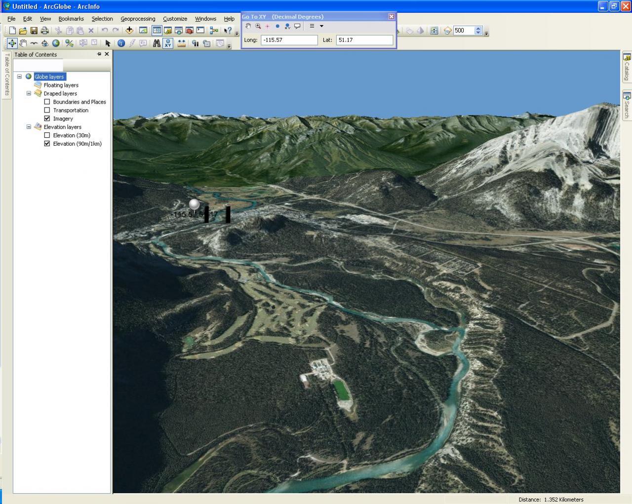
The hillshade effect shouldn't do anything if your surface appears too flat. You may need to set an exaggeration (like you mentioned for GE) in ArcGlobe. Go to View > Globe Properties and set it for the surface. You may also want to go to Customize > ArcGlobe Options and turn up the Level of Detail for Elevation layers. We don't show the full LOD to increase performance. My screenshots below are from the coordinates you gave me. I have no exaggeration applied, but high detail for elevation. When I exaggerate to 1.5 I don't like the appearence, but that could be just me.
The hillshade effect shouldn't do anything if your surface appears too flat. You may need to set an exaggeration (like you mentioned for GE) in ArcGlobe. Go to View > Globe Properties and set it for the surface. You may also want to go to Customize > ArcGlobe Options and turn up the Level of Detail for Elevation layers. We don't show the full LOD to increase performance. My screenshots below are from the coordinates you gave me. I have no exaggeration applied, but high detail for elevation. When I exaggerate to 1.5 I don't like the appearence, but that could be just me.
05-16-2011
08:08 PM
- Mark as New
- Bookmark
- Subscribe
- Mute
- Subscribe to RSS Feed
- Permalink
Thanks for your valuable instructions, Eric,
On the combination of your advices, it is working fine for us right now, including our very-high-resolution DEM & image services from MD.
In next step, we will follow the documentation to improve the globe services and see if we can make them faster.
By the way, most of our users like the factor 2, which makes the globe services in this continent look more realistic.
On the combination of your advices, it is working fine for us right now, including our very-high-resolution DEM & image services from MD.
In next step, we will follow the documentation to improve the globe services and see if we can make them faster.
Larry,
The hillshade effect shouldn't do anything if your surface appears too flat. You may need to set an exaggeration (like you mentioned for GE) in ArcGlobe. Go to View > Globe Properties and set it for the surface. You may also want to go to Customize > ArcGlobe Options and turn up the Level of Detail for Elevation layers. We don't show the full LOD to increase performance. My screenshots below are from the coordinates you gave me. I have no exaggeration applied, but high detail for elevation. When I exaggerate to 1.5 I don't like the appearence, but that could be just me.
By the way, most of our users like the factor 2, which makes the globe services in this continent look more realistic.