- Home
- :
- All Communities
- :
- Products
- :
- 3D
- :
- 3D Questions
- :
- Add z-value to shapefile made of multipatch data (...
- Subscribe to RSS Feed
- Mark Topic as New
- Mark Topic as Read
- Float this Topic for Current User
- Bookmark
- Subscribe
- Mute
- Printer Friendly Page
Add z-value to shapefile made of multipatch data (roofsurfaces)
- Mark as New
- Bookmark
- Subscribe
- Mute
- Subscribe to RSS Feed
- Permalink
Hey guys, i am pretty new in 3D analysis in ArcMap/Scene (10.5.1.)
It might be pretty simple question ( and it hopefully is).
I am working with 3D buildings of my hometown to analyze roof solar potential.
My final goal is to produce slope and aspect data.
What kind of data i use:
- 109 multipatch (.gml) files (each contains GroundSurface, RoofSurface, Wallsurface)
>> i am interested in Roofsurfaces to analyze slope and aspect
- 1 shapefile (it contains the 109 roofsurfaces)
>> i produced it myself and used it for 2D analysis (for example: footprint to estimate and distinguish flat and sloping roof types)
What i am trying to do is:
- add z_value to the shapefile
- to create a raster elevation map
- and finally do slope and aspect analysis
My problem is:
- i dont know much about multipatch and gml. data
- i dont know how to create this z-value out of my existing data and add it the attribute table of the shapefile (if had the z-value i could use polygon to raster)
> Is it even possible? Can i use the shapefile? Or do i have to use the raw data (multipatch / gml.)
I hope you can understand what i am trying to do, and what kind of data i use.
Thanks in advance,
JacobB
Solved! Go to Solution.
- Mark as New
- Bookmark
- Subscribe
- Mute
- Subscribe to RSS Feed
- Permalink
I just noticed that in the screenshot before I used the DWG files that you can download at the same site which can be read directly using ArcGIS (no conversion required).
- Mark as New
- Bookmark
- Subscribe
- Mute
- Subscribe to RSS Feed
- Permalink
Thank you very much for helps. It unforunately still does not work. It is probably an issue with the computers/servers i am working on (at my university that provides free ArcGis Software). I think its time get in touch with the administrator.
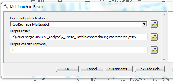
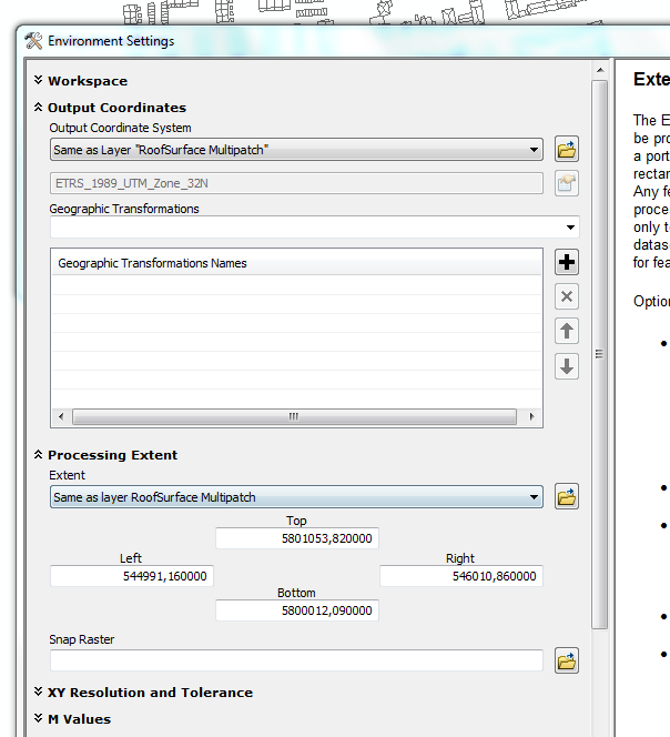
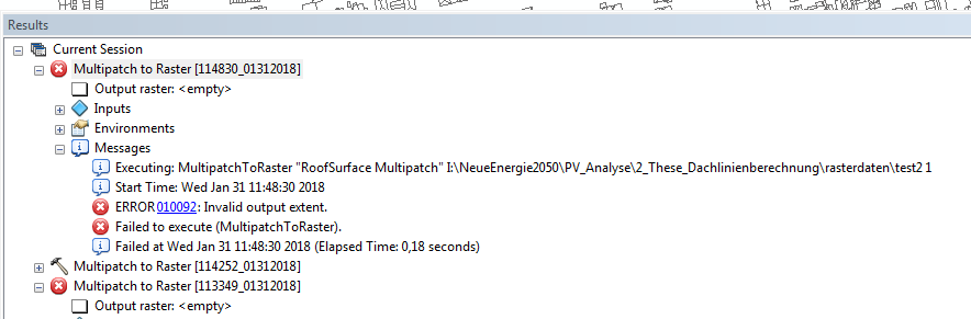
Here is what i tried for DWG files. The tool was successfully finished. But the output data seems to be unusable.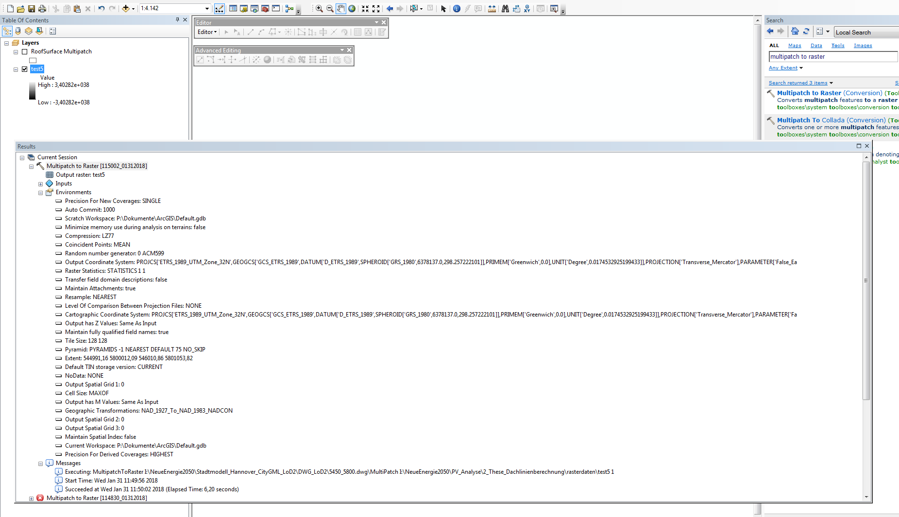
This what i tried with the GML data. Same ERROR as above.
1
2
3
- Mark as New
- Bookmark
- Subscribe
- Mute
- Subscribe to RSS Feed
- Permalink
I just wrote a script to process all the DWG files, but there seems to be a problem with some of them. When I have a (partial) result I will post it back here.
- Mark as New
- Bookmark
- Subscribe
- Mute
- Subscribe to RSS Feed
- Permalink
Find below the code that I wrote to process the data (DWG files):
import arcpy
def main():
import os
# settings
ws = r'C:\GeoNet\CityGML\DWG_LoD2'
fgdb = r'C:\GeoNet\CityGML\gdb\Hannover.gdb'
dsm_name = 'DSM'
slope_name = 'Slope'
aspect_name = 'Aspect'
cellsize = 1.0
sr = arcpy.SpatialReference(25832) # ETRS_1989_UTM_Zone_32N
# necessary environment settngs
arcpy.env.outputCoordinateSystem= sr
arcpy.env.workspace = ws
# create list of DWG file in folder (ws)
lst = arcpy.ListFiles("*.DWG")
# check out SA license
arcpy.CheckOutExtension("Spatial")
# loop through dwg file
lst_ras = []
lst_err = []
for dwg in lst:
dwg_mp = os.path.join(ws, dwg, 'MultiPatch')
print("Processing: {}".format(dwg))
# correct extent
ext = arcpy.Describe(dwg_mp).extent
ext_corr = CorrectExtent(ext, cellsize)
arcpy.env.extent = ext_corr
# define output raster name
ras_name = 'ras{}'.format(os.path.splitext(dwg)[0])
out_ras = os.path.join(fgdb, ras_name)
# create raster from multipatch and add to lost
try:
# some files create a error. I will skip those
arcpy.MultipatchToRaster_conversion(dwg_mp, out_ras, cellsize)
lst_ras.append(out_ras)
except Exception as e:
print "ERROR: ", e
lst_err.append(dwg)
print "DWG that produced Errors:"
print "\n - ".join(lst_err)
# mosaic raster into new raster
print("mosaic into new raster...")
input_ras = ';'.join(lst_ras)
arcpy.MosaicToNewRaster_management(input_ras, fgdb, dsm_name, sr, "32_BIT_FLOAT", cellsize, 1, "MEAN")
# set extent to output DSM
dsm_ras = os.path.join(fgdb, dsm_name)
arcpy.env.extent = dsm_ras
# calculate slope
print("calculate slope...")
slope_ras = os.path.join(fgdb, slope_name)
out_slope = arcpy.sa.Slope(dsm_ras, "PERCENT_RISE") # or use DEGREE
out_slope.save(slope_ras)
# calculate aspect
print("calculate aspect...")
aspect_ras = os.path.join(fgdb, aspect_name)
out_aspect = arcpy.sa.Aspect(dsm_ras)
out_aspect.save(aspect_ras)
def CorrectExtent(ext, cellsize):
ext.XMin = divmod(ext.XMin, cellsize)[0]
ext.YMin = divmod(ext.YMin, cellsize)[0]
ext.XMax = divmod(ext.XMax, cellsize)[0] + cellsize
ext.YMax = divmod(ext.YMax, cellsize)[0] + cellsize
return ext
if __name__ == '__main__':
main()
The file geodatabase with the resulting rasters (DSM, slope, aspect), is about 1.5GB (compressed a little over 210MB). You can download it here: HannoverCityGML.zip - Google Drive
- Mark as New
- Bookmark
- Subscribe
- Mute
- Subscribe to RSS Feed
- Permalink
Thank you so much!
- Mark as New
- Bookmark
- Subscribe
- Mute
- Subscribe to RSS Feed
- Permalink
You are welcome
- « Previous
-
- 1
- 2
- Next »
- « Previous
-
- 1
- 2
- Next »