- Home
- :
- All Communities
- :
- Products
- :
- ArcGIS Pro
- :
- ArcGIS Pro Questions
- :
- Mosaic to new raster
- Subscribe to RSS Feed
- Mark Topic as New
- Mark Topic as Read
- Float this Topic for Current User
- Bookmark
- Subscribe
- Mute
- Printer Friendly Page
Mosaic to new raster
- Mark as New
- Bookmark
- Subscribe
- Mute
- Subscribe to RSS Feed
- Permalink
- Report Inappropriate Content
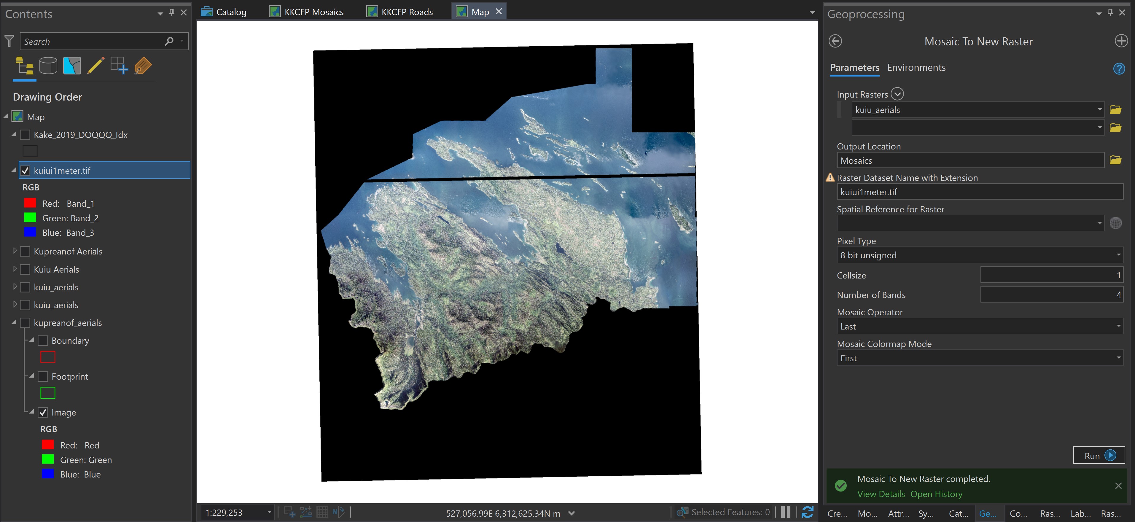
Hi, I have 50 aerials images (.tif, 4 band, 8 bit unsigned, 30cm). I created a mosaic dataset to display them. Then I use the mosaic to new raster tool to create a raster that I can run a supervised image classification on. I have been unable to get the new raster to come together correctly. I have tried many different settings and the result always includes areas that are black, no data or 0,0,0 areas. These areas display as having data when I load the image tiles individually but I must admit I can't seem to get the display of the mosaic dataset to work very well either.
- build overviews or no?
- build pyramids or no? How many levels?
- what about statistics?
I have hunted for straightforward guidance on 4 band .tifs but have had no luck so have been running the trial and error gamut and have yet to get the mosaic or new raster from mosaic to display well at a range of full extent down to 1:5000.
What parameters should I be focusing on in troubleshooting this?
- Mark as New
- Bookmark
- Subscribe
- Mute
- Subscribe to RSS Feed
- Permalink
- Report Inappropriate Content
It's been a while since I've done this but statistics of your rasters should help any colour balancing in the mosaic. The input for mosaic to new raster is the original tiles and not the MD? Overviews and pyramid levels are simply viewing caches for your MD and overviews should not be created if you're doing any analysis from the MD. If your tiles have blank spaces, using radiometric extents could work.
Edit.
Apologies I forgot to look at the supplied image!
I would also move up to 16 bit unsigned. If you get it looking how you like in the MD you can always export it to a single raster.
- Mark as New
- Bookmark
- Subscribe
- Mute
- Subscribe to RSS Feed
- Permalink
- Report Inappropriate Content
Imagery and Remote Sensing tagged and shared
- Mark as New
- Bookmark
- Subscribe
- Mute
- Subscribe to RSS Feed
- Permalink
- Report Inappropriate Content
If you are going to use ArcGIS Pro to run your supervised image classification then there is no need to create a single tif image. Pro will accept the mosaic data set as input into geoprocessing tools.
But note that if you are planning on running the segment mean shift tool, then the required input is a 3 band 8 bit image. I usually use the Extract Bands raster function to extract the 3 bands I need and then under General I change the pixel type to 8 bit. I then use the output of this raster function as input into the segment mean shift tool.
- Mark as New
- Bookmark
- Subscribe
- Mute
- Subscribe to RSS Feed
- Permalink
- Report Inappropriate Content
If you have areas with 0,0,0 value (or close to it) that should not be visible you should edit your footprint so it will not be inside it.
The BuildFootprint GP tool might help but if it is straight lines the easiest way is just to edit the polygon directly.
After it looks right you can run all functions, export to single image etc with no problems.
Have fun
- Mark as New
- Bookmark
- Subscribe
- Mute
- Subscribe to RSS Feed
- Permalink
- Report Inappropriate Content
I've had the same problem. I'm trying to mosaic a bunch of NAIP tiles without much overlap (if any) and I've tried almost all the "Mosaic Operators" like first, last, max (which I think should work), mean, etc. Every time, mostly black output tiles. Really weird cause this tool used to work like a charm. I've tried in ArcMap and Pro, same results.