- Home
- :
- All Communities
- :
- Products
- :
- ArcGIS Pro
- :
- ArcGIS Pro Questions
- :
- ArcGIS Pro 2.4: Issues with exporting map series (...
- Subscribe to RSS Feed
- Mark Topic as New
- Mark Topic as Read
- Float this Topic for Current User
- Bookmark
- Subscribe
- Mute
- Printer Friendly Page
ArcGIS Pro 2.4: Issues with exporting map series (clipped to index feature) to PDF
- Mark as New
- Bookmark
- Subscribe
- Mute
- Subscribe to RSS Feed
- Permalink
I created a map series using the "Clip to Index Feature" option, and it displays correctly within ArcGIS Pro - each layout in the series correctly shows the features in my map clipped to each of the 9 features in the index layer (except for a basemap layer which I opted to exclude). However, when I export the 9 maps, many of the features which appear clipped in the layout view reappear in the resulting pdf/image, including the full index layer. Only one of the layers, a line layer, displays as correctly clipped. I played around with all of the different export options - .png, .jpg, .eps, .pdf - they all give the same result (pdf is my ideal format). I also tried checking/unchecking all the map export options that seemed relevant. I am attaching screenshots of how the map looks before and after export. Has anyone experienced a similar issue and/or know what might be causing this/how to fix it?
- Mark as New
- Bookmark
- Subscribe
- Mute
- Subscribe to RSS Feed
- Permalink
Hi Emma,
I'm unaware of any general clipped map / map series export issue. A quick test similar to the screenshots provided exported as expected.
Can you contact Esri Support? They are better equipped to handle troubleshooting steps and gather bug data. They can be contacted at https://support.esri.com/en/contact-tech-support.
Thanks,
Tom
- Mark as New
- Bookmark
- Subscribe
- Mute
- Subscribe to RSS Feed
- Permalink
Thanks for the response - I did work with ESRI support and wanted to share the result in case it helps anyone. The solution was to place the index layer at the bottom of the drawing order, below all other layers (except, in my case, the basemap). I assumed it should be at the top because in the directions for creating a map series, it says it will select the topmost polygon layer as the index layer by default unless otherwise specified. Hopefully this is just a temporary issue! This must just be a Pro thing because I recreated the process using data driven pages and it worked regardless of drawing order.
- Mark as New
- Bookmark
- Subscribe
- Mute
- Subscribe to RSS Feed
- Permalink
Hi Emma,
The index layer does not have to be at the top of the drawing order. I can be anywhere in the drawing order. We could have picked the bottom most polygon layer for the default as easily as the top most.
Since the drawing order affects the output of your map I would still consider this a bug. One in which I have not been able to reproduce. Was an issue logged with technical support?
Thanks,
Tom
- Mark as New
- Bookmark
- Subscribe
- Mute
- Subscribe to RSS Feed
- Permalink
I had exactly the same problem.
Thank you Emma for sharing the solution.
- Mark as New
- Bookmark
- Subscribe
- Mute
- Subscribe to RSS Feed
- Permalink
I have the same issue, also with 2.5
does esri have an answer to this problem ?
Thanks Regards
- Mark as New
- Bookmark
- Subscribe
- Mute
- Subscribe to RSS Feed
- Permalink
Hi Jacques,
Can you contact Esri Support? They are better equipped to handle troubleshooting steps and gather bug data. They can be contacted at https://support.esri.com/en/contact-tech-support.
Thanks,
Tom
- Mark as New
- Bookmark
- Subscribe
- Mute
- Subscribe to RSS Feed
- Permalink
Hello All,
We have an official bug (BUG-000128447) with reproducible steps that result in layers not clipping properly in the exported result. The key finding is if the last layer in the draw order has any transparency.
For example, here I have a map where the last visible layer in the draw order has transparency. Only the "Clip Layer" (blue outlined polygons) are excluded from the clip.
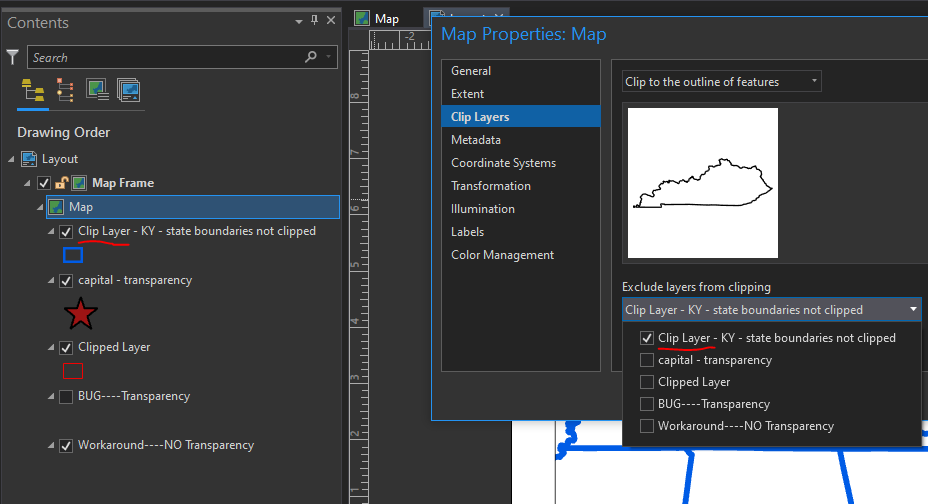
I export and nothing seems clipped.

Note that the last visible layer is "BUG----Transparency". If this layer is moved in the draw order so that it is not the last visible layer the features are clipped in the export as expected. In the example below I've moved this layer above "Clipped Layer".

In cases where you want/need the layer order unchanged you can add a non-transparent "placeholder" with no symbol and place it the bottom of the draw order. Make sure that it is tuned on.

Export result.

This is one scenario that we know, and more importantly, can reproduce, where clipping is not working as expected. If your scenario/draw order is not similar to that outlined above, please contact support at https://support.esri.com/en/contact-tech-support.
Hopefully, this information can help you all move forward with your work.
Tom
- Mark as New
- Bookmark
- Subscribe
- Mute
- Subscribe to RSS Feed
- Permalink
This seems to also include polygons where there is no color for the fill portion. After trying a bunch of different configurations based on suggestions here, I removed my polygon county file and replaced it with a polyline version, and it worked. I would have loved to have kept the labels for the counties, but not as much as I wanted the clipping to work correctly.
- Mark as New
- Bookmark
- Subscribe
- Mute
- Subscribe to RSS Feed
- Permalink
Hi Matt,
Thanks for adding to this discussion. However, I believe you are seeing the same issue. Polygons always have a fill. When there is no color fill it just means the fill is 100% transparent.

You should still be able to use the work-around described above.
Thanks,
Tom