- Home
- :
- All Communities
- :
- Products
- :
- ArcGIS Online
- :
- ArcGIS Online Questions
- :
- "Add Layer from File" options breakdown
- Subscribe to RSS Feed
- Mark Topic as New
- Mark Topic as Read
- Float this Topic for Current User
- Bookmark
- Subscribe
- Mute
- Printer Friendly Page
"Add Layer from File" options breakdown
- Mark as New
- Bookmark
- Subscribe
- Mute
- Subscribe to RSS Feed
- Permalink
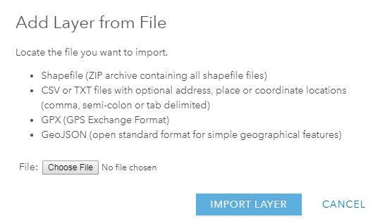
Has anyone broke down the pro's and con's of the different options for adding a layer form file?
With the perspective of a free/public account, the options include:
Zipped Shapefile, .csv or .txt, GPX, GeoJson.
- Zipped Shapefile
this seems to be my default choice but kind of assumes you have a way to create a shapefile and adds extra steps for processing updates. It would be nice option for ArcPRO to export shapefiles directly to zipped folder.
- .csv or .txt
Seems like a great option for creating data from scratch using the provided story-map templates, also good if you're not using desktop software (PRO or other)
- GPX
Seems like the obvious choice if you have data from a GPS, not sure why you would use this otherwise. not even sure you can convert non-gps sourced data to GPX?
- GeoJson
This seems similar .csv/.txt but am unfamiliar so mostly would like a comparison between these two options.
I am looking for which option is the best/easiest for updating data either using online, desktop ESRI, or non ESRI file format.
I am also looking for which option is the best for sharing the data with others, or having the ability to export the data/file from online.
Apologies if this has been covered elsewhere but i could not find any other discussions.
Thanks,
M.Catanzarite
Ann Arbor,MI
- Mark as New
- Bookmark
- Subscribe
- Mute
- Subscribe to RSS Feed
- Permalink
From the perspective of a free/public account, there isn't much difference between the file based layers you mention. All of these file types are converted within the map to a feature collection. While you can edit the layers within the map, you can't really update them with an updated file without removing the layer and adding it again. And there really isn't any export ability.
There is one somewhat dynamic file based layer supported in the map with a public account. You can add a CSV by reference. In this case, you choose the 'Add layer from web' option and choose the CSV option. Here's a documentation link.
Adding a URL-based CSV file containing latitude, longitude coordinates to your map allows you to display the latest CSV data when the map is refreshed. For example, you could display up-to-date earthquake information by adding a CSV file containing earthquake locations (latitude, longitude) that is frequently updated on the USGS Earthquake Hazards Program website. Each time your map is opened, the earthquake layer is refreshed with the latest data. If you want to change the frequency at which the layer is refreshed, you can set a refresh interval.
The thing to keep in mind when adding layers to maps in a public account is that the layer's data is stored in the map. Thus, there is a limit to the number of features the map can store across all layers.
Mike