- Home
- :
- All Communities
- :
- Developers
- :
- Native Maps SDKs
- :
- Java Maps SDK Questions
- :
- How to create Tile Package from ArcGIS Runtime SDK...
- Subscribe to RSS Feed
- Mark Topic as New
- Mark Topic as Read
- Float this Topic for Current User
- Bookmark
- Subscribe
- Mute
- Printer Friendly Page
How to create Tile Package from ArcGIS Runtime SDK ?
- Mark as New
- Bookmark
- Subscribe
- Mute
- Subscribe to RSS Feed
- Permalink
- Report Inappropriate Content
Hi,
My requirement is to create a tile package from a set of rasters using Runtime App , Since Runtime does not support creation of tile packages, so I tried to create a geoprocessing package tool using ArcMap (Data Management Tool - Create Map Tile Package ), but when I run my geoprocessing service , I am unable to understand how should I give Input Map document ?According to the ArcMap Documentation , the service should take an Input paramater in_map(Map)
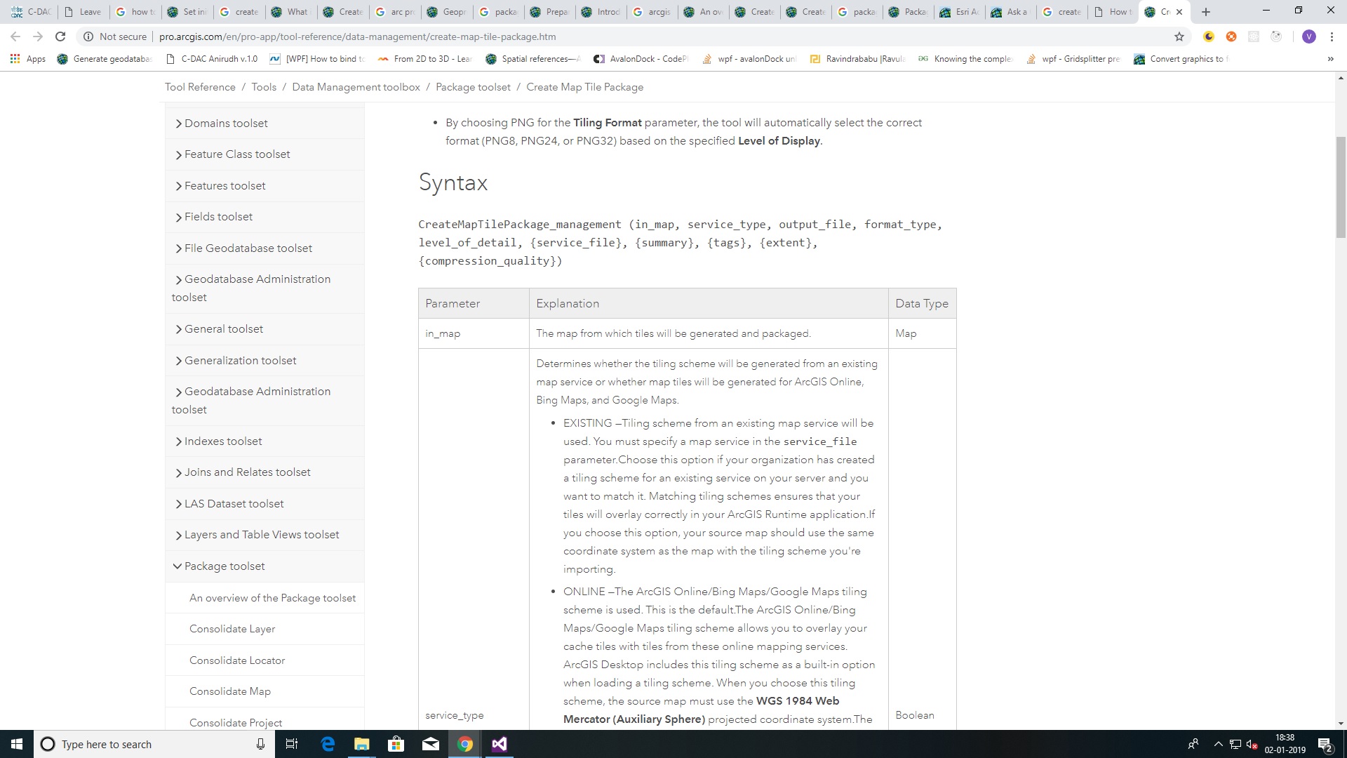
but, when I run the service , I don't find any input parameter as (in_map) Map
What I am doing wrong ??
Or what should I do to create TilePackage using runtime ??
- Mark as New
- Bookmark
- Subscribe
- Mute
- Subscribe to RSS Feed
- Permalink
- Report Inappropriate Content
Hi
Can you let me know what versions of software you are using for ArcMap, Runtime / Local Server.
Thanks
- Mark as New
- Bookmark
- Subscribe
- Mute
- Subscribe to RSS Feed
- Permalink
- Report Inappropriate Content
Hi,
I am using ArcMap 10.6 and Local Server 100.3
- Mark as New
- Bookmark
- Subscribe
- Mute
- Subscribe to RSS Feed
- Permalink
- Report Inappropriate Content
Thanks for the info. I'm talking to the Local Server team to see what could be the issue.
- Mark as New
- Bookmark
- Subscribe
- Mute
- Subscribe to RSS Feed
- Permalink
- Report Inappropriate Content
Hi,
Unfortunately the tool `Create Map Tile Package` is not currently supported. It was mistakenly added to the documentation when re-publishing the topic for v100.4.
But it is a tool we would like to support in future and the team has an existing issue logged to investigate adding support. Following your question, we will raise the priority of that issue in our backlog.
Cheers
Mike
- Mark as New
- Bookmark
- Subscribe
- Mute
- Subscribe to RSS Feed
- Permalink
- Report Inappropriate Content
Hi Mike,
My biggest issue is , that my requirement is to do data preperation using my Runtime App (i.e creation of packages like tile package, mobile map package,geodatabase etc). Please provide with me some workflow or process as to how can I achieve this requirement ?
- Mark as New
- Bookmark
- Subscribe
- Mute
- Subscribe to RSS Feed
- Permalink
- Report Inappropriate Content
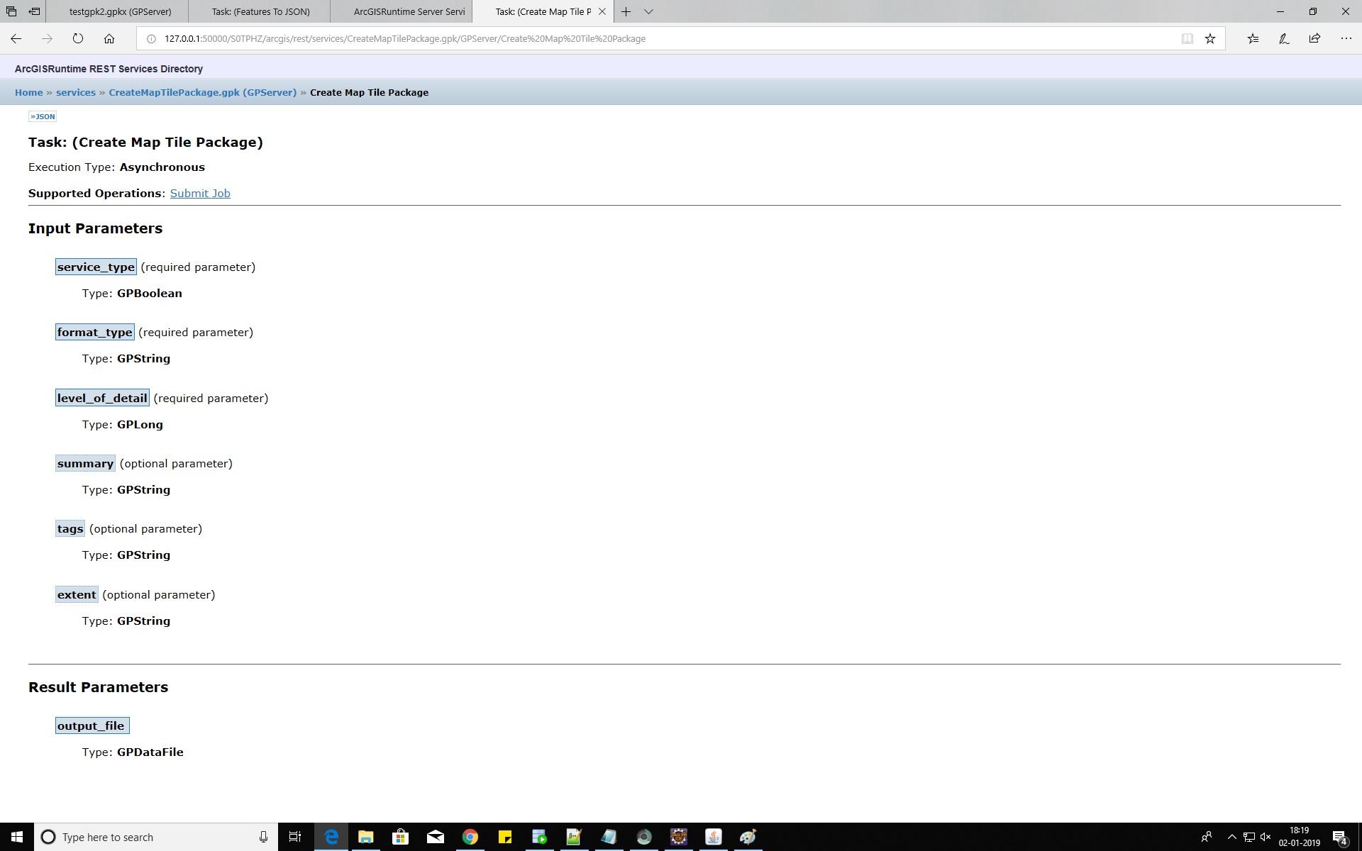
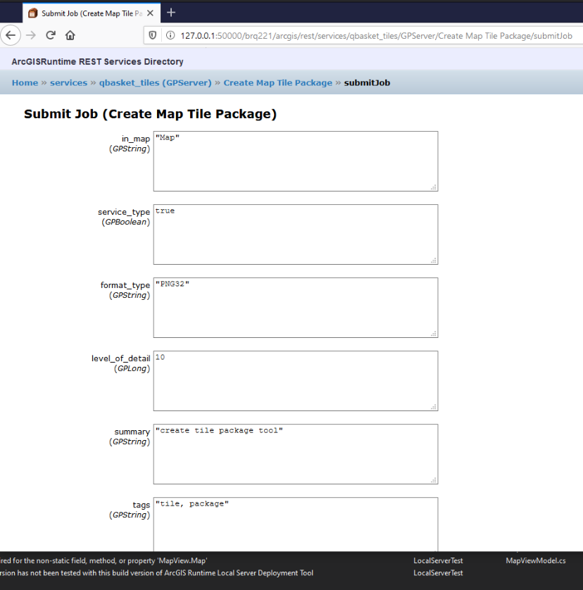
Michael Branscomb Was this functionality ever added? I've created a geoprocessing package from the Create Map Tile Package tool and I'm trying to run it in Local server. I can see the parameter for in_map but don't know what string to pass it. How to I find the name of my runtime map, I don't see a name property.
Vijit Wadhwa Did you every come to a solution for this?
Thanks
Drew
- Mark as New
- Bookmark
- Subscribe
- Mute
- Subscribe to RSS Feed
- Permalink
- Report Inappropriate Content
Hi,
Unfortunately the tool `Create Map Tile Package` is not currently supported for use with ArcGIS Runtime Local Server (Local Server geoprocessing tools support—ArcGIS Runtime SDK for .NET | ArcGIS for Developers).
I will open a new issue to investigate if it is possible to add this in a future release of ArcGIS Runtime Local Server (for geoprocessing packages created with ArcGIS Pro).
Looking at your screen capture it appears you may also have tried to publish the tool directly as a package. You should create a Model or Python Script to expose the geoprocessing tool in the appropriate way for a service (for example to control the input parameters and their data types). For more information see A quick tour of authoring and sharing geoprocessing services—Documentation | Documentation for ArcGI....
Thanks
Mike
- Mark as New
- Bookmark
- Subscribe
- Mute
- Subscribe to RSS Feed
- Permalink
- Report Inappropriate Content
Thanks for getting back to me Michael.
I created the geoprocessing package by using the package results geoprocessing tool. I was following the documentation here. The instructions just link to the publish results tool. Good to know a script or model wrapper is preferred.
All of which is moot anyway. I will have to investigate GDAL raster to create my tiles unless you have another suggestion?