- Home
- :
- All Communities
- :
- Developers
- :
- JavaScript Maps SDK
- :
- JavaScript Maps SDK Questions
- :
- Change Search Widget Text in CSS?
- Subscribe to RSS Feed
- Mark Topic as New
- Mark Topic as Read
- Float this Topic for Current User
- Bookmark
- Subscribe
- Mute
- Printer Friendly Page
- Mark as New
- Bookmark
- Subscribe
- Mute
- Subscribe to RSS Feed
- Permalink
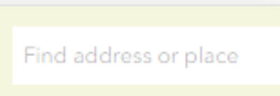
How can I change "Find address or place" to "search" in the CSS? Can I override Esri's main.css file?
I put in "content: 'search;'" here. There was no change.
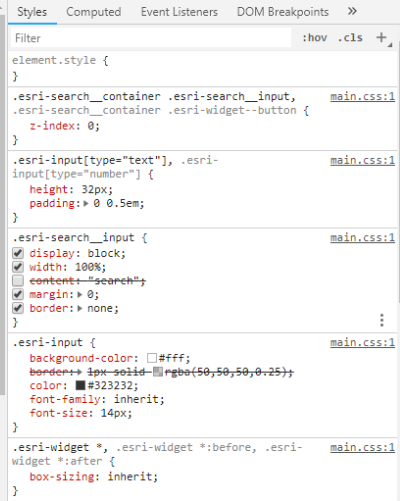
Here's where it seems to be in one of my CSS files.
@media (max-width: 480px)
.esri-input.esri-search__input {
visibility: visible;
font-size: 12px;
margin-right: 0px;
}I tried this but there was no change:
content: "search" !important;Solved! Go to Solution.
Accepted Solutions
- Mark as New
- Bookmark
- Subscribe
- Mute
- Subscribe to RSS Feed
- Permalink
Jared,
Here is what I have tested and works for your scenario:
//search widget
var searchWidget = new Search({
view: view,
container: "searchDiv"
});
searchWidget.watch('activeSource', function(evt){
evt.placeholder = "blah blah";
});- Mark as New
- Bookmark
- Subscribe
- Mute
- Subscribe to RSS Feed
- Permalink
Jared,
You can not do this using css. You have to do this in JS code.
require(["dojo/i18n!esri/nls/jsapi"], function(b) {
b.widgets.Search.main.allPlaceholder = "blah blah";
});You can add this to the Search widget.js startup function.
- Mark as New
- Bookmark
- Subscribe
- Mute
- Subscribe to RSS Feed
- Permalink
Jared,
Did this work for you?
- Mark as New
- Bookmark
- Subscribe
- Mute
- Subscribe to RSS Feed
- Permalink
Robert,
I haven't got it to work yet. I incorporated what you had, but there's something wrong with the script somewhere. The app isn't showing the search box among other things.
require([
"esri/Map",
"esri/views/MapView",
"esri/layers/FeatureLayer",
"esri/layers/GraphicsLayer",
"esri/widgets/Search",
"esri/widgets/Home",
"esri/widgets/Legend",
"esri/widgets/Expand",
"dojo/i18n!esri/nls/jsapi",
"dojo/domReady!"
],
function (
Map, MapView, FeatureLayer, GraphicsLayer, Search, Home, Legend, Expand, b
)
//search widget
var searchWidget = new Search({
view: view,
container: "searchDiv",
index: 2
b.widgets.Search.main.allPlaceholder = "search";
});EDIT: Here's the search elements in the body.
<div id="searchParentDiv" style="float:right;">
<div id="searchDiv" style="float:right;"></div>
</div>- Mark as New
- Bookmark
- Subscribe
- Mute
- Subscribe to RSS Feed
- Permalink
Here's the whole script as it stands now.
<!DOCTYPE html>
<html>
<head>
<link rel="icon" href="http://www.willcogis.org/website2014/gis/images/gisseal_thumbnail.png">
<meta charset="utf-8">
<meta name="viewport" content="initial-scale=1,maximum-scale=1,user-scalable=no">
<title>Will County Attractions</title>
<!--links to external css and Esri api-->
<link rel="stylesheet" href="splash.css">
<link rel="stylesheet" href="attractions.css">
<link rel="stylesheet" href="https://js.arcgis.com/4.9/esri/css/main.css">
<script src="https://js.arcgis.com/4.9/"></script>
<!--JavaScript beginns-->
<script>
require([
"esri/Map",
"esri/views/MapView",
"esri/layers/FeatureLayer",
"esri/layers/GraphicsLayer",
"esri/widgets/Search",
"esri/widgets/Home",
"esri/widgets/Legend",
"esri/widgets/Expand",
"dojo/i18n!esri/nls/jsapi",
"dojo/domReady!"
],
function (
Map, MapView, FeatureLayer, GraphicsLayer, Search, Home, Legend, Expand, b
) {
//set basemap
var map = new Map({
basemap: "topo-vector",
});
//set map view
var view = new MapView({
container: "viewDiv",
map: map,
scale: 1300000,
center: [-87.95, 41.47],
//popup settings for attractions layer
popup: {
dockEnabled: true,
dockOptions: {
//set dock/undock button from on pop-up
buttonEnabled: false,
//ignore the default sizes that trigger responsive docking
breakpoint: false,
}
}
});
//***widgets***
//home widget
var homeBtn = new Home({
view: view,
});
view.ui.add(homeBtn, "top-left");
//search widget
var searchWidget = new Search({
view: view,
container: "searchDiv",
index: 2
b.widgets.Search.main.allPlaceholder = "search";
});
//legend widget
var legend = new Expand({
content: new Legend({
view: view,
//style: "card"
}),
view: view,
expanded: false
});
view.ui.add(legend, "top-left");
//***popups***
//popup template
var template = { //autocasts the new template
title: "<img src={logo} height='50' width='50'><font color= '#008000' font size= '3px'>{Name}",
content: [{ //set content elements in the order to display
type: "fields",
fieldInfos: [{
fieldName: "Type",
label: "Type",
visible: true,
}, {
fieldName: "Address",
label: "Address",
visible: true,
}, {
fieldName: "Website",
label: "Website",
visible: true,
}, {
fieldName: "Photo",
label: "Photo",
visible: false,
}]
}, {
// You can set a media element within the popup as well. This
// can be either an image or a chart. You specify this within
// the mediaInfos. Similar to text elements, media can only be set within the content.
type: "media",
mediaInfos: [{
type: "image",
value: {
sourceURL: "{Photo}"
}
}]
}]
};
//set Rt 66 photo in popup
var template2 = { //autocasts the new template
title: "<font size= '3px' font color= '#008000'>Route 66",
content: [{ //set content elements in the order to display
type: "fields",
fieldInfos: [{
fieldName: "Photo",
label: "Photo",
visible: false,
}]
}, {
type: "media",
mediaInfos: [{
type: "image",
value: {
sourceURL: "{Photo}"
}
}]
}]
};
//set I&M canal photo in popup
var template3 = { //autocasts the new template
title: "<font size= '3px' font color= '#008000'>Illinois & Michigan Canal",
content: [{ //set content elements in the order to display
type: "fields",
fieldInfos: [{
fieldName: "Photo",
label: "Photo",
visible: false,
}]
}, {
type: "media",
mediaInfos: [{
type: "image",
value: {
sourceURL: "{Photo}"
}
}]
}]
};
//***feature layers***
//add will county boundary
var boundary = new FeatureLayer({
url: "https://services.arcgis.com/fGsbyIOAuxHnF97m/arcgis/rest/services/County_Limits/FeatureServer/0?toke...",
//id: "boundary",
});
map.add(boundary);
//add Rt 66
var rt66 = new FeatureLayer({
url: "https://services.arcgis.com/fGsbyIOAuxHnF97m/arcgis/rest/services/Rte_66/FeatureServer/0?token=xWHh8...",
// id: "rt66",
popupTemplate: template2,
outFields: ["*"]
});
map.add(rt66);
//add canal
var canal = new FeatureLayer({
url: "https://services.arcgis.com/fGsbyIOAuxHnF97m/arcgis/rest/services/Illinois_and_Michigan_Canal/Featur...",
popupTemplate: template3,
//id: "canal",
});
map.add(canal);
//add preserves
var preserves = new FeatureLayer({
url: "https://services.arcgis.com/fGsbyIOAuxHnF97m/arcgis/rest/services/Will_County_Forest_Preserves/Featu...",
//id: "preserves",
//zoom: 1,
});
map.add(preserves);
//add attraction feature layer
//reference the popup template instance in the popuptmeplate property of featurelayer
var attractions = new FeatureLayer({
url: "https://services.arcgis.com/fGsbyIOAuxHnF97m/arcgis/rest/services/Attractions/FeatureServer/0?token=...",
id: "attractions",
visible: true,
popupTemplate: template,
outFields: ["*"]
});
map.add(attractions);
//***From here down deals with the query by type dropdown menu***
var attTypeSelect = document.getElementById("attractions");
view.ui.add("infoDiv", "left");
//query all features from the attractions layer
view.when(function () {
return attractions.when(function () {
var query = attractions.createQuery();
return attractions.queryFeatures(query);
});
})
.then(getValues)
.then(getUniqueValues)
.then(addToSelect);
// return an array of all the values in the
// Type field of the attractions layer
function getValues(response) {
var features = response.features;
var values = features.map(function (feature) {
return feature.attributes.Type;
});
return values;
}
// return an array of unique values in
// the Type field of the attractions layer
function getUniqueValues(values) {
var uniqueValues = [];
values.forEach(function (item, i) {
if ((uniqueValues.length < 1 || uniqueValues.indexOf(item) === -1) &&
(item !== "")) {
uniqueValues.push(item);
}
});
return uniqueValues;
}
// Add the unique values to the attractions type
// select element. This will allow the user
// to filter attractions by type.
function addToSelect(values) {
values.sort();
values.forEach(function (value) {
var option = document.createElement("option");
option.text = value;
attTypeSelect.add(option);
});
return setattractionsDefinitionExpression(attTypeSelect.value);
}
// set the definition expression on the attractions
// layer to reflect the selection of the user
function setattractionsDefinitionExpression(newValue) {
attractions.definitionExpression = "Type = '" + newValue + "'";
if (!attractions.visible) {
attractions.visible = true;
}
return queryForAttractionGeometries();
}
// set a new definitionExpression on the attractions layer
attTypeSelect.addEventListener("change", function () {
var type = event.target.value;
setattractionsDefinitionExpression(type);
});
// Get all the geometries of the attractions layer
// the createQuery() method creates a query
// object that respects the definitionExpression
// of the layer
function queryForAttractionGeometries() {
var attractionsQuery = attractions.createQuery();
return attractions.queryFeatures(attractionsQuery)
.then(function (response) {
attractionsGeometries = response.features.map(function (feature) {
return feature.geometry;
});
return attractionsGeometries;
});
}
}
)
</script>
</head>
<body>
<header class="app_header">
<img src="http://www.willcogis.org/website2014/gis/images/gisseal_thumbnail.png" alt="GIS Seal" style="float:left;width:48px;height:46px;"
color='#f5f5dc'>
<div id="searchParentDiv" style="float:right;">
<div id="searchDiv" style="float:right;"></div>
</div>
<div class="a">
<h1 class="local">Will County Attractions</h1>
</div>
</header>
<div id="infoDiv">
Select type:
<select id="attractions"></select>
</div>
<div id="viewDiv"></div>
<!--Splashscreen***-->
<div class="overlay-wrap">
<input type="checkbox" name="hide" id="hide">
<label class="hide" for="hide">Explore Map</label>
<div class="overlay2">
<div class="overlay">
<div class="overlay-inner">
<div class="message">
<h1>Will County Attractions</h1>
<p>
<h3>This map highlights the many things to do in Will County, IL.
What you will find is parks, places of historical significance, sporting events, nature preservs and
museums. Please note that this may not be a complete listing
and some locations may have restricted use and/or limited hours. All information is subject
to change.</h2>
</p>
</div>
</div>
</div>
</div>
</div>
<!--***-->
</body>
</html>- Mark as New
- Bookmark
- Subscribe
- Mute
- Subscribe to RSS Feed
- Permalink
I guess I should post the CSS too. The other CSS file (splash.css) you see referenced in the script doesn't haven't any search elements.
html,
body,
#viewDiv {
overflow: hidden;
padding: 0;
margin: 0;
height: 100%;
width: 100%;
}
#viewDiv {
height: calc(100% - 75px);
}
/*search*/
#searchParentDiv {
height: 100%;
}
/*search*/
.esri-search {
border: none;
margin-top: 7px;
margin-right: 5px;
}
div.a {
/* center the header*/
text-align: center;
}
/* Style the header */
header.app_header {
background-color: beige;
padding: 2px;
font-size: 12px;
font-family: 'Sans Serif';
color: black;
max-height: 50px;
}
/*legend*/
.esri-legend.esri-widget--panel.esri-widget {
max-height: 600px;
max-width: 600px;
}
/*.esri-expand__mask.esri-expand__mask--expanded {
max-height: 0px;
}*/
.esri-legend__layer-caption {
display: none;
}
/*query dropdown*/
#infoDiv {
background-color: black;
color: white;
font-family: 'Sans Serif';
padding: 2px;
width: 100%;
}
/*query*/
#results {
font-weight: bolder;
}
/*this section is for mobile devices*/
@media (max-width: 480px) {
h1 {
font-size: 14px;
visibility: visible;
z-index: 2
}
header {
width: 420px;
height: 100px;
}
#infoDiv {
font-size: 14px;
font-family: 'sitka';
padding: 2px;
}
/*popuptemplate*/
.esri-popup__main-container.esri-widget {
width: 300px !important;
max-height: 350px !important;
}
.esri-popup__header {
height: 100px;
max-width: 300px;
background-color: beige;
}
/*search*/
#searchParentDiv {
height: 100%;
}
/*search*/
.esri-search {
border: none;
margin-top: 7px !important;
margin-right: 53px !important;
}
}- Mark as New
- Bookmark
- Subscribe
- Mute
- Subscribe to RSS Feed
- Permalink
Jared,
My example code was for changing the search widgets all place holder sting in the 3.x API. In the 4.x API somethings are a lot easier and can be done in the constructor as Carson mentions. Here is the documentation reference:
- Mark as New
- Bookmark
- Subscribe
- Mute
- Subscribe to RSS Feed
- Permalink
Robert,
Using the snippet you gave me as such is throwing two syntax errors:
It says there should be a colon between b and widgets and there should be a comma at the end instead of a semi-colon. Even then the app wasn't displaying anything.
//search widget
var searchWidget = new Search({
view: view,
container: "searchDiv",
index: 2,
b:widgets.Search.main.allPlaceholder = "search",
});- Mark as New
- Bookmark
- Subscribe
- Mute
- Subscribe to RSS Feed
- Permalink
You need to set the allPlaceholder property. There's no CSS involved.
//search widget
var searchWidget = new Search({
view: view,
container: "searchDiv",
index: 2,
allPlaceholder = "search"
});
- Mark as New
- Bookmark
- Subscribe
- Mute
- Subscribe to RSS Feed
- Permalink
Carson,
There's no error in the text editor, but the app isn't displaying any search box or anything in the MapView now.
Edit: The error from Google Chrome console, which is referring to your line 6:
attractions.html:69 Uncaught SyntaxError: Invalid shorthand property initializerEDIT: Following the browser's recommendation to change the shorthand, I swapped
allPlaceholder = "search address"for
allPlaceholder: "search address"but then there were multiple errors in the console:
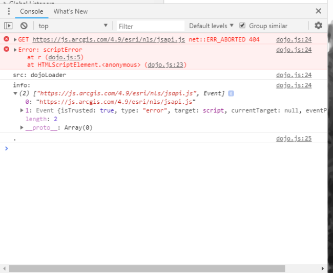
Is there something missing in the require section?
require([
"esri/Map",
"esri/views/MapView",
"esri/layers/FeatureLayer",
"esri/layers/GraphicsLayer",
"esri/widgets/Search",
"esri/widgets/Home",
"esri/widgets/Legend",
"esri/widgets/Expand",
"dojo/i18n!esri/nls/jsapi",
"dojo/domReady!"
],
function (
Map, MapView, FeatureLayer, GraphicsLayer, Search, Home, Legend, Expand, allPlaceholder
)