Turn on suggestions
Auto-suggest helps you quickly narrow down your search results by suggesting possible matches as you type.
Cancel
- Home
- :
- All Communities
- :
- Developers
- :
- JavaScript Maps SDK
- :
- JavaScript Maps SDK Questions
- :
- Count-dependent rendering? Switch layer on/off dep...
Options
- Subscribe to RSS Feed
- Mark Topic as New
- Mark Topic as Read
- Float this Topic for Current User
- Bookmark
- Subscribe
- Mute
- Printer Friendly Page
Count-dependent rendering? Switch layer on/off depending on number of features
Subscribe
1050
1
02-10-2011 07:49 PM
02-10-2011
07:49 PM
- Mark as New
- Bookmark
- Subscribe
- Mute
- Subscribe to RSS Feed
- Permalink
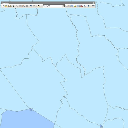
I have a set of multiple census layers, where the largest scale layer is very detailed over heavily populated areas, and quite coarse over remote areas.
I need to display the detailed layer when it makes sense to do so - which is not necessarily at the same scale across the entire map.
These screenshots illustrate the problem. At a scale of 1:500k the layer should display in rural areas:
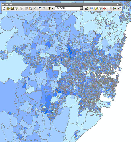
But in urban areas, the layer shouldn't display until about 1:100k:
Using the JavaScript API and REST layers, is there any way to count the features in the current map extent, and turn the layer off/on accordinly? Eg, if there are fewer than 50 polygons, show the detailed layer, otherwise show the coarse layer.
Thanks,
Steve
I need to display the detailed layer when it makes sense to do so - which is not necessarily at the same scale across the entire map.
These screenshots illustrate the problem. At a scale of 1:500k the layer should display in rural areas:
But in urban areas, the layer shouldn't display until about 1:100k:
Using the JavaScript API and REST layers, is there any way to count the features in the current map extent, and turn the layer off/on accordinly? Eg, if there are fewer than 50 polygons, show the detailed layer, otherwise show the coarse layer.
Thanks,
Steve
1 Reply
02-11-2011
05:24 AM
- Mark as New
- Bookmark
- Subscribe
- Mute
- Subscribe to RSS Feed
- Permalink
I have a set of multiple census layers, where the largest scale layer is very detailed over heavily populated areas, and quite coarse over remote areas.
I need to display the detailed layer when it makes sense to do so - which is not necessarily at the same scale across the entire map.
These screenshots illustrate the problem. At a scale of 1:500k the layer should display in rural areas:
But in urban areas, the layer shouldn't display until about 1:100k:
Using the JavaScript API and REST layers, is there any way to count the features in the current map extent, and turn the layer off/on accordinly? Eg, if there are fewer than 50 polygons, show the detailed layer, otherwise show the coarse layer.
Thanks,
Steve
Do a spatial query against your polygon layer using the current extent as query.geometry and then query.executeForCount(query, callback?, errback?) to get the count of the polygon.