- Home
- :
- All Communities
- :
- Industries
- :
- Transportation
- :
- Public Transit
- :
- Public Transit Questions
- :
- Need help with creating multimodal network and err...
- Subscribe to RSS Feed
- Mark Topic as New
- Mark Topic as Read
- Float this Topic for Current User
- Bookmark
- Subscribe
- Mute
- Printer Friendly Page
Need help with creating multimodal network and error with Add GTFS to a Network Dataset Step 2.
- Mark as New
- Bookmark
- Subscribe
- Mute
- Subscribe to RSS Feed
- Permalink
I am a college student looking to create a multimodal network so that I can locate the best restaurants in the area within 5-7 minutes walking distance from my school and within 10-15 minutes of MTA public transportation. I downloaded the following data from http://transitfeeds.com/:
1. Metro-North Railroad GTFS
2. MTA Manhattan GTFS
3. NYC Bus Company GTFS
4. NYC Subway GTFS
5. NYC Subway Supplemented GTFS
I also downloaded the NYC street data from the following source:
https://data.cityofnewyork.us/City-Government/NYC-Street-Centerline-CSCL-/exjm-f27b/data
I created a geodatabase for these files under the feature dataset TransNet. I added the NYC street data to the dataset. I downloaded the "Add GTFS to a Network Dataset" tool to aid me in creating a multimodal network from this data above. The first step, "Generate transit lines and stops," was executed successfully in ArcCatalog 10.6 and added the two feature classes "TransitLines" and "Stops" to the feature dataset for all the GTFS files above I put into the tool. However, for step 2, "Generate Stop Street Connectors," the tool produced the following error at step 8 of 14 for the wheelchair portion:
Messages:
Executing: GenerateStop2StreetConnectors C:\Users\Leah\Downloads\HCBestRs18BU.gdb\TransNet C:\Users\Leah\Downloads\HCBestRs18BU.gdb\TransNet\NYCStreets # 40 Meters
Start Time: Thu Apr 26 20:50:29 2018
Running script GenerateStop2StreetConnectors...
Snapping stops to streets network...
Creating connector lines between stops and streets...
Handling wheelchair_boarding...
Creating vertices in streets at location of stops...
(This step might take a while.)
Failed to generate stop-street connectors.
Failed script GenerateStop2StreetConnectors...
Traceback (most recent call last):
File "c:\program files (x86)\arcgis\desktop10.6\ArcToolbox\Toolboxes\scripts\GenerateStop2StreetConnectors.py", line 289, in <module>
arcpy.management.Integrate([[outStreetsSplit, 1], [TempSnappedStops, 2]])
File "c:\program files (x86)\arcgis\desktop10.6\arcpy\arcpy\management.py", line 2128, in Integrate
raise e
ExecuteError: ERROR 999999: Error executing function.
Invalid Topology [Negative point valence.]
Failed to execute (Integrate).
Failed to execute (GenerateStop2StreetConnectors).
Failed at Thu Apr 26 21:11:26 2018 (Elapsed Time: 20 minutes 56 seconds)
I used the check geometry tool to make sure something wasn't wrong with the three feature classes now in the dataset, and only the NYC street data came back with short line segment errors. I used the repair geometry tool to get rid of them. Then, I ran the tool again and got the same error. I am at a loss on how to fix this. If it cannot be fixed, can I still use it to create my network?
Thank you!
Solved! Go to Solution.
Accepted Solutions
- Mark as New
- Bookmark
- Subscribe
- Mute
- Subscribe to RSS Feed
- Permalink
Hello, Destiny. You did all the right things to diagnose and try to fix this problem. Indeed, it sounds like a geometry problem with the streets feature class. The actual failure is in the Integrate tool.
Someone else reported a similar problem to me a while back. Like you, he ran Check Geometry and Repair Geometry, and it didn't help. We weren't able to figure out the cause of the problem. However, he copied the files to a new geodatabase, and it magically worked after that.
If that doesn't work, my suggestion would be to try running the Integrate tool on your street data in ArcMap, just by itself (ie, not inside the Add GTFS to a Network Dataset toolbox). If you're able to reproduce the same error, then this is something you can call Esri Tech Support about (because it's an official supported tool). They can try to debug what's causing the failure.
- Mark as New
- Bookmark
- Subscribe
- Mute
- Subscribe to RSS Feed
- Permalink
Just checking in. Did you ever get this to work?
- Mark as New
- Bookmark
- Subscribe
- Mute
- Subscribe to RSS Feed
- Permalink
Hi Melinda,
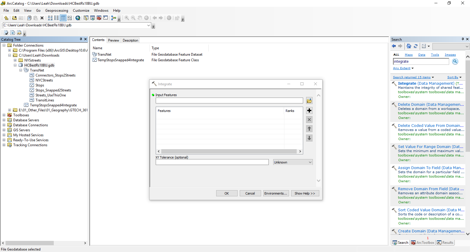
Thank you for your response! I just tried pasting the TransNet dataset into a new geodatabase and it did not work, so I deleted the new geodatabase. How exactly would I use the integrate tool to fix the problem? Which features should I input? I have provided a screenshot of my geodatabase below:
- Mark as New
- Bookmark
- Subscribe
- Mute
- Subscribe to RSS Feed
- Permalink
I just used the Integrate tool with the features "TransLines" and "Stops." I deleted the features produced from "Step 2: GenerateStop2StreetConnectors" so the tool could start over fresh making those features also. Once I ran the tool again, it worked! Thank you!
- Mark as New
- Bookmark
- Subscribe
- Mute
- Subscribe to RSS Feed
- Permalink
I'm glad it worked, although I can't necessarily explain why. Post again if you encounter further problems.
- Mark as New
- Bookmark
- Subscribe
- Mute
- Subscribe to RSS Feed
- Permalink
Hi Melinda,
I have received the following error after building my network with the "Create Network Dataset from Template" tool:
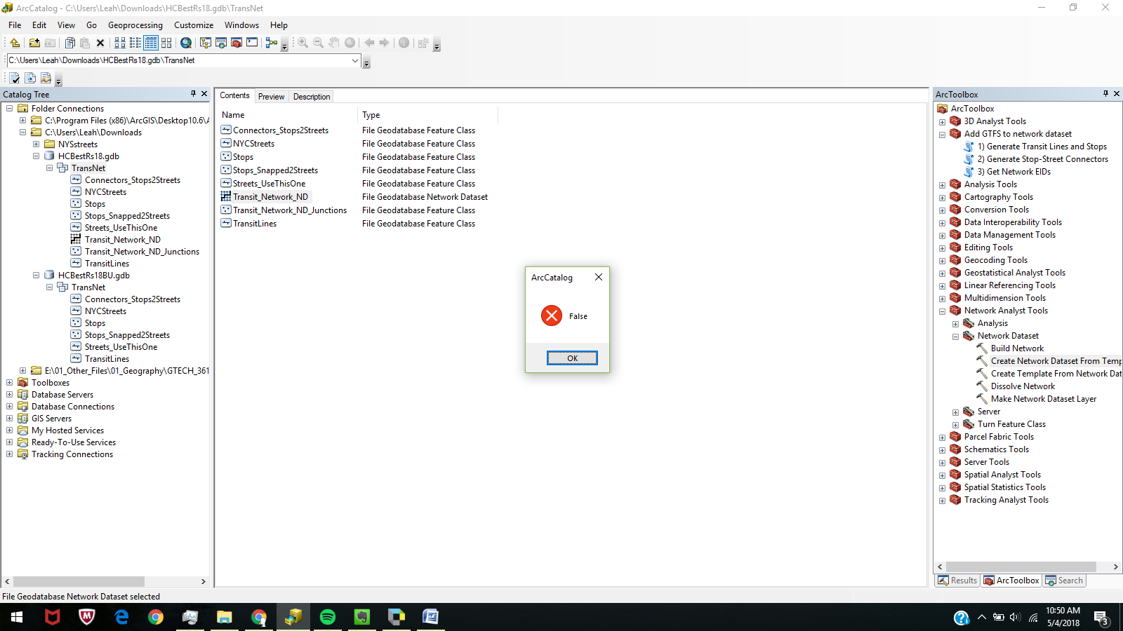
I cannot open the network in ArcMap at all. My data is not projected. Could this be the problem? Thank you!
- Mark as New
- Bookmark
- Subscribe
- Mute
- Subscribe to RSS Feed
- Permalink
The preview of the network looks like this in ArcCatalog:

Does this look accurate?
- Mark as New
- Bookmark
- Subscribe
- Mute
- Subscribe to RSS Feed
- Permalink
Your data's projection shouldn't matter.
When you say you "can't open the network in ArcMap at all", did you get a pop-up message with an FDO error with a negative number? If not, what are the symptoms?
Possibly something didn't work right when you installed Add GTFS to a Network Dataset, and this makes it so that you can't open the network dataset that uses the special transit evaluator. However, it's pretty hard to tell. Would you be able to share your geodatabase so I can take a look? The best thing to do is to zip the .gdb into a zip file and post it on a file sharing site and send me the link.
- Mark as New
- Bookmark
- Subscribe
- Mute
- Subscribe to RSS Feed
- Permalink
Yes, I did receive the FDO error with a negative number in ArcMap. How do I attach the zipped geodatabase here? Thank you!