- Home
- :
- All Communities
- :
- Industries
- :
- Transportation
- :
- Public Transit
- :
- Public Transit Questions
- :
- Need help with creating multimodal network and err...
- Subscribe to RSS Feed
- Mark Topic as New
- Mark Topic as Read
- Float this Topic for Current User
- Bookmark
- Subscribe
- Mute
- Printer Friendly Page
Need help with creating multimodal network and error with Add GTFS to a Network Dataset Step 2.
- Mark as New
- Bookmark
- Subscribe
- Mute
- Subscribe to RSS Feed
- Permalink
I am a college student looking to create a multimodal network so that I can locate the best restaurants in the area within 5-7 minutes walking distance from my school and within 10-15 minutes of MTA public transportation. I downloaded the following data from http://transitfeeds.com/:
1. Metro-North Railroad GTFS
2. MTA Manhattan GTFS
3. NYC Bus Company GTFS
4. NYC Subway GTFS
5. NYC Subway Supplemented GTFS
I also downloaded the NYC street data from the following source:
https://data.cityofnewyork.us/City-Government/NYC-Street-Centerline-CSCL-/exjm-f27b/data
I created a geodatabase for these files under the feature dataset TransNet. I added the NYC street data to the dataset. I downloaded the "Add GTFS to a Network Dataset" tool to aid me in creating a multimodal network from this data above. The first step, "Generate transit lines and stops," was executed successfully in ArcCatalog 10.6 and added the two feature classes "TransitLines" and "Stops" to the feature dataset for all the GTFS files above I put into the tool. However, for step 2, "Generate Stop Street Connectors," the tool produced the following error at step 8 of 14 for the wheelchair portion:
Messages:
Executing: GenerateStop2StreetConnectors C:\Users\Leah\Downloads\HCBestRs18BU.gdb\TransNet C:\Users\Leah\Downloads\HCBestRs18BU.gdb\TransNet\NYCStreets # 40 Meters
Start Time: Thu Apr 26 20:50:29 2018
Running script GenerateStop2StreetConnectors...
Snapping stops to streets network...
Creating connector lines between stops and streets...
Handling wheelchair_boarding...
Creating vertices in streets at location of stops...
(This step might take a while.)
Failed to generate stop-street connectors.
Failed script GenerateStop2StreetConnectors...
Traceback (most recent call last):
File "c:\program files (x86)\arcgis\desktop10.6\ArcToolbox\Toolboxes\scripts\GenerateStop2StreetConnectors.py", line 289, in <module>
arcpy.management.Integrate([[outStreetsSplit, 1], [TempSnappedStops, 2]])
File "c:\program files (x86)\arcgis\desktop10.6\arcpy\arcpy\management.py", line 2128, in Integrate
raise e
ExecuteError: ERROR 999999: Error executing function.
Invalid Topology [Negative point valence.]
Failed to execute (Integrate).
Failed to execute (GenerateStop2StreetConnectors).
Failed at Thu Apr 26 21:11:26 2018 (Elapsed Time: 20 minutes 56 seconds)
I used the check geometry tool to make sure something wasn't wrong with the three feature classes now in the dataset, and only the NYC street data came back with short line segment errors. I used the repair geometry tool to get rid of them. Then, I ran the tool again and got the same error. I am at a loss on how to fix this. If it cannot be fixed, can I still use it to create my network?
Thank you!
Solved! Go to Solution.
- Mark as New
- Bookmark
- Subscribe
- Mute
- Subscribe to RSS Feed
- Permalink
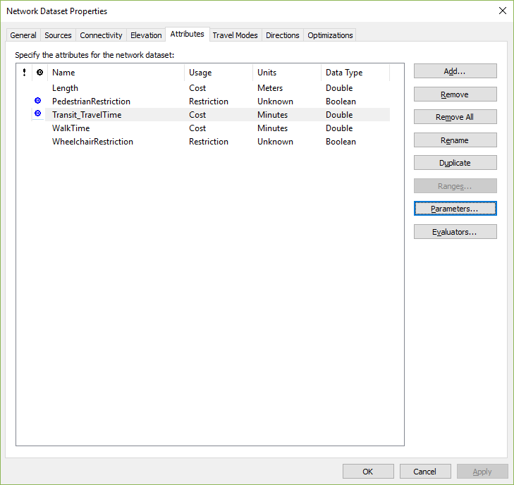
Probably there's something wrong with the way you've set up your Streets_UseThisOne evaluators for your Transit_TravelTime attribute. You need to make sure the walk time is being calculated correctly. Otherwise, you might get weird results like this because the network thinks you can walk super fast and get pretty much anywhere within 10 minutes.
Can you post a screenshot of the evaluators dialog for that attribute?
- Mark as New
- Bookmark
- Subscribe
- Mute
- Subscribe to RSS Feed
- Permalink
Hi Melinda,
I have another issue. My school only has ArcGIS 10.3 installed. I cannot open the network from school. Also, the school computer system does not allow anything extra to be installed on their computers. Is this network only compatible with ArcGIS 10.6 and with the Add GTFS to a Network Dataset installed? I am getting the error message with the number again when I try to open the network in ArcGIS 10.3. Otherwise, the network cannot be read at school, which is a problem for me using it at school and even sharing the network with others who do not have ArcGIS 10.6 or the Add GTFS to a Network Dataset tool already installed.
I was also required to make a model out of my data, but when I turned in the model's toolbox using the created network, the model disappeared from the toolbox I turned in and I lost points because the toolbox was empty. Could models from toolboxes disappear if the the data are unreadable such as the network? I know I saved it properly at home and when I ran it, no error messages appeared. I am going to inform my instructor of this issue. I will check the Streets_UseThisOne when I get home. Thanks for your replies.
- Mark as New
- Bookmark
- Subscribe
- Mute
- Subscribe to RSS Feed
- Permalink
Hi Destiny. So sorry for these problems.
Unfortunately, as stated in the user's guide, a network dataset that uses the special transit evaluator will not work on any machine that has not had the transit evaluator "registered" to it, and you'll see that negative FDO error message number if you try to open it or add it to the map.
The network dataset itself should work fine back to ArcMap 10.1, as long as the machine has the evaluator installed. It's only the Create Network Dataset From Template tool that requires 10.6 or higher, and that's only used to create the network. Once it's created, it should be good to go in any ArcMap version.
Regarding the Model Builder model: Probably, as you said, the model disappeared because it referenced the transit network dataset, and your professor's machine didn't have the evaluator installed. Not the greatest behavior on ArcMap's part, I agree, but in using this custom transit evaluator, you're kind of out on the fringes of supported functionality anyway. Please feel free to show this response to your professor if you want to argue your points back. I'd also be happy to speak to your school's systems administrator if you want to try to get this installed on one of the school machines and they need an Esri staff member to explain what the thing does.
- Mark as New
- Bookmark
- Subscribe
- Mute
- Subscribe to RSS Feed
- Permalink
Thank you very much for the explanation and offer! I have shown my professor this message.
- Mark as New
- Bookmark
- Subscribe
- Mute
- Subscribe to RSS Feed
- Permalink
Here are some screenshots that may help with discovering what's going wrong with the Transit_TravelTime attribute service area:


Please let me know if this helps. Thank you!
- Mark as New
- Bookmark
- Subscribe
- Mute
- Subscribe to RSS Feed
- Permalink
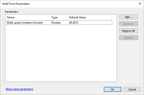
I think I should include the length information as well:

Should the value be shape_length instead?
- Mark as New
- Bookmark
- Subscribe
- Mute
- Subscribe to RSS Feed
- Permalink
Hmm. All that looks correct, as it should be, since you built the network from the template anyway. (Incidentally, Shape and shape_length basically do the same thing here, so it doesn't matter which you use.)
I looked at your Service Area screenshots again, and I noticed two things:
1) "Use time" is unchecked in your Service Area settings. You need to turn the time of day on and set it to something specific or else the transit stuff won't be used at all.
2) Although your Service Area extends all the way to the edge of your network, the service area break value is like 5.6E-3, which is really tiny. So there's definitely some kind of unit conversion issue happening. Since you used the template, it ought to be working, but maybe there's something wrong with the template.
Would you be able to share your gdb with the network in it so I can take a look? Just zip up the whole gdb and put it on a file share somewhere I can download.
- Mark as New
- Bookmark
- Subscribe
- Mute
- Subscribe to RSS Feed
- Permalink
Hi Melinda, how can I PM you the zipped file? I do not wish to share the database publicly. Thank you.
- Mark as New
- Bookmark
- Subscribe
- Mute
- Subscribe to RSS Feed
- Permalink
Just sent you a PM through GeoNet. You should be able to reply to it, I think.
- « Previous
- Next »
- « Previous
- Next »