- Home
- :
- All Communities
- :
- Developers
- :
- ArcGIS API for Python
- :
- ArcGIS API for Python Questions
- :
- Python API: TypeError on geometry column for Spati...
- Subscribe to RSS Feed
- Mark Topic as New
- Mark Topic as Read
- Float this Topic for Current User
- Bookmark
- Subscribe
- Mute
- Printer Friendly Page
Python API: TypeError on geometry column for Spatial DataFrame of local data source
- Mark as New
- Bookmark
- Subscribe
- Mute
- Subscribe to RSS Feed
- Permalink
At the DevSummit, I learned that you could load a feature class from a local source into a Spatial DataFrame using the ArcGIS API for Python. Specifically, the documentation implies this can be done using the from_featureclass() method in the features module to create a Spatial DataFrame. I followed the example in this notebook for loading a local shapefile into a Spatial DataFrame (sdf).
I am using Jupyter Notebook as my IDE. My environment is the default arcgispro-py3 environment from ArcGIS Pro. I know I am able to successfully create a Spatial DataFrame objectbecause when I run the object through the type() function in my Jupyter Notebook I get the following:
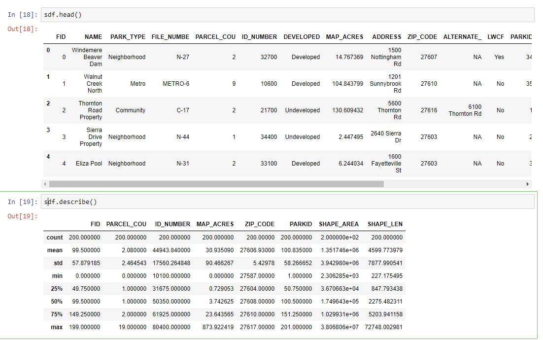
arcgis.features._data.geodataset.geodataframe.SpatialDataFrameI am able to return sdf.head() and sdf.describe() without issue.
However, if I run sdf.info() I get the following error:
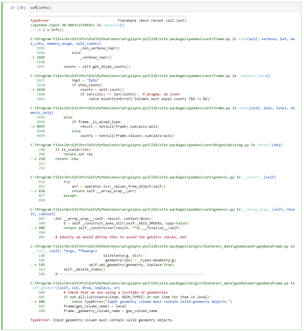
I have tried this on point, line and multipolygon shapefiles, and file GDB feature classes. All locally loaded data eventually returns this error. I am able to successfully create Spatial DataFrames from AGOL data and do not receive the error above when running sdf.info().
The documentation and examples I've been able to find about properly loading local data into a Spatial DataFrame seems pretty scattered and undeveloped at the moment. Looking at this error and the process I've described, does anyone have any suggestions on how I might troubleshoot this further? Thanks!
- Mark as New
- Bookmark
- Subscribe
- Mute
- Subscribe to RSS Feed
- Permalink
There must be a bug with the info() method. I get an error when using ArcGIS API for Python 1.4 and a FGDB feature class, but the error is different than yours:
In[1]: from arcgis.features import SpatialDataFrame
In[2]: sdf = SpatialDataFrame.from_featureclass(r'D:\Default.gdb\rangerdistrict')
In[3]: sdf.head()
Out[3]:
OBJECTID ADMINISTRATIVEUNITID GIS_ACRES SUBTYPE_ADMINUNIT \
0 1 99090906010343 1034747.229 3
1 2 99090901010343 751074.231 3
2 3 99090902010343 645092.789 3
3 4 99090905010343 718352.206 3
4 5 99090907010343 739293.634 3
MODIFIED_DATE LAST_UPDATE STD_ADMINUNIT_FK \
0 2012-11-21 20:27:01 D6A68001115E2DD6E04400144F6A461C 99090906010343
1 2012-10-23 20:12:35 D6A6800111582DD6E04400144F6A461C 99090901010343
2 2018-01-01 00:00:00 D6A68001115A2DD6E04400144F6A461C 99090902010343
3 NaT D6A68001115C2DD6E04400144F6A461C 99090905010343
4 NaT D6A6800111602DD6E04400144F6A461C 99090907010343
PROJECTED_ACRES UNITNAME \
0 1035050.403 Lacroix Ranger District
1 751068.672 Laurentian Ranger District
2 645092.875 Gunflint Ranger District
3 718380.285 Kawishiwi Ranger District
4 739307.990 Tofte Ranger District
SHAPE
0 {'rings': [[[-93.18671221699998, 48.6278650500...
1 {'rings': [[[-91.90858970199997, 47.6436073560...
2 {'rings': [[[-90.87772452699994, 48.2389176710...
3 {'rings': [[[-91.16214670599999, 48.1362494970...
4 {'rings': [[[-91.08318138799996, 48.0494390910...
In[4]: sdf.describe()
Out[4]:
OBJECTID GIS_ACRES SUBTYPE_ADMINUNIT PROJECTED_ACRES
count 5.000000 5.000000e+00 5.0 5.000000e+00
mean 3.000000 7.777120e+05 3.0 7.777800e+05
std 1.581139 1.494691e+05 0.0 1.495960e+05
min 1.000000 6.450928e+05 3.0 6.450929e+05
25% 2.000000 7.183522e+05 3.0 7.183803e+05
50% 3.000000 7.392936e+05 3.0 7.393080e+05
75% 4.000000 7.510742e+05 3.0 7.510687e+05
max 5.000000 1.034747e+06 3.0 1.035050e+06
In[5]: sdf.info()
Traceback (most recent call last):
File "C:\Program Files\ArcGIS\Pro\bin\Python\envs\arcgispro-py3\lib\site-packages\IPython\core\interactiveshell.py", line 2862, in run_code
exec(code_obj, self.user_global_ns, self.user_ns)
File "<ipython-input-6-faf896058227>", line 1, in <module>
sdf.info()
File "C:\Program Files\ArcGIS\Pro\bin\Python\envs\arcgispro-py3\lib\site-packages\pandas\core\frame.py", line 1845, in info
_verbose_repr()
File "C:\Program Files\ArcGIS\Pro\bin\Python\envs\arcgispro-py3\lib\site-packages\pandas\core\frame.py", line 1809, in _verbose_repr
counts = self.count()
File "C:\Program Files\ArcGIS\Pro\bin\Python\envs\arcgispro-py3\lib\site-packages\pandas\core\frame.py", line 5645, in count
result = notna(frame).sum(axis=axis)
File "C:\Program Files\ArcGIS\Pro\bin\Python\envs\arcgispro-py3\lib\site-packages\pandas\core\dtypes\missing.py", line 212, in notna
res = isna(obj)
File "C:\Program Files\ArcGIS\Pro\bin\Python\envs\arcgispro-py3\lib\site-packages\pandas\core\dtypes\missing.py", line 45, in isna
return _isna(obj)
File "C:\Program Files\ArcGIS\Pro\bin\Python\envs\arcgispro-py3\lib\site-packages\pandas\core\dtypes\missing.py", line 60, in _isna_new
return obj._constructor(obj._data.isna(func=isna))
File "C:\Program Files\ArcGIS\Pro\bin\Python\envs\arcgispro-py3\lib\site-packages\arcgis\features\_data\geodataset\geodataframe.py", line 241, in __init__
geometry = [_types.Geometry(g) for g in self['SHAPE'].tolist()]
File "C:\Program Files\ArcGIS\Pro\bin\Python\envs\arcgispro-py3\lib\site-packages\arcgis\features\_data\geodataset\geodataframe.py", line 241, in <listcomp>
geometry = [_types.Geometry(g) for g in self['SHAPE'].tolist()]
File "C:\Program Files\ArcGIS\Pro\bin\Python\envs\arcgispro-py3\lib\site-packages\arcgis\geometry\_types.py", line 137, in __call__
if len(iterable) > 0:
TypeError: object of type 'bool' has no len()- Mark as New
- Bookmark
- Subscribe
- Mute
- Subscribe to RSS Feed
- Permalink
Thanks for checking this. I just generated this error from a layer loaded from AGOL using an environment with version 1.4 of the Python API. Frustrating 😕
- Mark as New
- Bookmark
- Subscribe
- Mute
- Subscribe to RSS Feed
- Permalink
I see the same behaviour.
It's solved by commenting out the check at lines 605 and 606 in the geodataframe.py file. So I suspect the geometry column in file geodatabases isn't being identified correctly.
I'm looking at the geometry that gets passed to set_geometry in that file to see if there's a way to correct it.
When you create the SpatialDataFrame from an object on AGOL and run .info() it doesn't pass through this geometry check at all.
- Mark as New
- Bookmark
- Subscribe
- Mute
- Subscribe to RSS Feed
- Permalink
I'll give this a try. I was going to include a piece about Spatial DataFrames in a presentation to colleagues this week, but I'm going to have to pass until this portion of the API is more reliable.
- Mark as New
- Bookmark
- Subscribe
- Mute
- Subscribe to RSS Feed
- Permalink
Thank you for reporting this issue. We will investigate it and work on a fix.