- Home
- :
- All Communities
- :
- Industries
- :
- Electric
- :
- Electric Questions
- :
- Documentation of Data Model/Dictionary for Utility...
- Subscribe to RSS Feed
- Mark Topic as New
- Mark Topic as Read
- Float this Topic for Current User
- Bookmark
- Subscribe
- Mute
- Printer Friendly Page
Documentation of Data Model/Dictionary for Utility Network
- Mark as New
- Bookmark
- Subscribe
- Mute
- Subscribe to RSS Feed
- Permalink
Hi there,
I'm struggling to find any information/documentation on Esri's website regarding the base data model/data dictionary of the Utility Network for ArcGIS Enterprise (10.6). I have have seen some information on other websites (eg. SSP Innovations) which is approx. 2 years old but would have thought Esri would have this information available from my.esri or somewhere else.
I'm interested in Electric & Telco at the moment
Thanks
- Mark as New
- Bookmark
- Subscribe
- Mute
- Subscribe to RSS Feed
- Permalink
There is some information available here: Domain networks—ArcGIS Pro | ArcGIS Desktop
Attached you will find the ArcGIS Electric Network data model. Telco will be released at 10.6.1 this summer and is not a part of the ArcGIS Utility Network Management extension (10.6).
- Mark as New
- Bookmark
- Subscribe
- Mute
- Subscribe to RSS Feed
- Permalink
Xander,
Thankyou for this. Where does the attached pdf file come from? Is there more information available about this additional fields that are added to the features when an Electric model is applied and the default domain values that are configured against the ASSETGROUP & ASSETTYPE fields?
Also, I haven't seen any feature/table that relates to construction code or something similar that can be used in an ERP/EAM system to generate Bill of Materials/Store requisition for the field crews to build, etc.
Thanks
- Mark as New
- Bookmark
- Subscribe
- Mute
- Subscribe to RSS Feed
- Permalink
It is true that the documentation available does not cover all topics yet. There will be a mayor update on the documentation for the 10.6.1 release this summer when Telco will also be included.in the ArcGIS Utility Network Management extension (UNME).
The utility network data model does only include the necessary fields that UNME needs to offer all the capabilities of the extension. You can expand the data model by adding additional fields.
Constructions like poles are managed in the Structure network—ArcGIS Pro | ArcGIS Desktop . Electric and telco can share a single structure network. You can have multiple domain network and can do tracing across different domain networks. I have seen examples of tracing the affected water clients when a pump station is shut down due to a power failure.
The Utility network layer properties—ArcGIS Pro | ArcGIS Desktop is the place to examine the configured asset groups and asset types.
Some definitions from Utility network vocabulary—ArcGIS Pro | ArcGIS Desktop :
Asset group
The asset group of a feature defines its broad classification. The ASSETGROUP field for each network feature class is defined as the subtype field. Further classification of features is added by assigning attribute domains at the subtype level on the ASSETTYPE field.Asset type
The asset type attribute of a feature defines a finer classification for each asset group in a network layer. The ASSETTYPE field in a network layer is a text field linked to an attribute domain of values. These attribute domains are assigned on the ASSETTYPE field at the subtype level for each network feature class. The ASSETGROUP field is defined as the subtype field for each network feature class. This allows a rich classification of network features using the asset group as a major classification and asset type as a minor classification of features.
- Mark as New
- Bookmark
- Subscribe
- Mute
- Subscribe to RSS Feed
- Permalink
Xander,
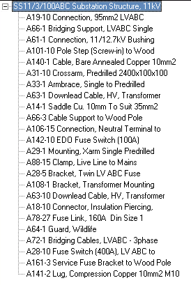
Sorry what I meant by construction refers to a code that gives a generic meaning to what the structure/assembly/device is within the GIS. An example would 'SS11/3/100ABC' and this would be used against an assembly feature representing a substation or a transformer bank as the assetgroup. The construction code 'SS11/3/100ABC' means SS=Substation, 11=11kV primary voltage, 3=3Phase, 100=100kVA & ABC=connected to LV bundled OH mains.
In our ERP, this code is mapped to other items that represent logical groupings of store stock items with associated cost & labour which can be bundled up and issued to the field crews.
Thanks for the information above
- Mark as New
- Bookmark
- Subscribe
- Mute
- Subscribe to RSS Feed
- Permalink
The utility model by default only contains those attributes that are necessary to enable the UNME functionality. The user can expand the number of attributes according to their specific needs. I can imagine that you could have an attribute rule (calculation rule, see An overview of attribute rules—Geodatabases | ArcGIS Desktop ) that updates this code automatically based on substation, voltage, phase and other factors.
- Mark as New
- Bookmark
- Subscribe
- Mute
- Subscribe to RSS Feed
- Permalink
Hi all, here's the current status and release plan for the Utility Network Industry Configurations:
| Industry | Current Version | Release Date | Location |
|---|---|---|---|
| Electric Distribution | 1 | 1/17/2018 | http://esriurl.com/elecdistunconfig |
| Electric Transmission | In Development | Anticipated Q3 2018 | - |
| Gas | 1 | 1/17/2018 | http://esriurl.com/gasunconfig |
| Sewer | In Development | Anticipated Q3 2018 | - |
| Stormwater | In Development | Anticipated Q3 2018 | - |
| Telecommunications | In Development | Anticipated Q2 2019 | - |
| Water Distribution | 1 | 1/17/2018 | http://esriurl.com/waterdistunconfig |