I am working with several layers including parcels, and the standard township, section, quarter, quarter-quarter layers. When creating new features, say a parcel, I read from survey notes and draw from the legal descriptions. I have noticed that my inputs as feet get converted to meters. Is there a way to change this? Also, my measurements are not adding up like they should. For example, a description will read go N 100 feet to North line of SE 1/4. My "100 foot" line does not intersect with that line. Therefore all my drawing are off. Is this a projection error? I checked all layers and all seem to match projection system, projection, and all the stats like meridian, easting, northing, latitude of origin, and linear unit.
If anyone could direct me to the right path to get my data back in line that would be much appreciated!
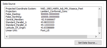
This is the data for all layers (parcels, sections, quarters, and quarter-quarters)