- Home
- :
- All Communities
- :
- Products
- :
- ArcGIS Pro
- :
- ArcGIS Pro Questions
- :
- profile graph in ArcGIS pro 2.0
- Subscribe to RSS Feed
- Mark Topic as New
- Mark Topic as Read
- Float this Topic for Current User
- Bookmark
- Subscribe
- Mute
- Printer Friendly Page
- Mark as New
- Bookmark
- Subscribe
- Mute
- Subscribe to RSS Feed
- Permalink
- Report Inappropriate Content
I am using ArcGIS pro 2.0 with 3D analyst extension, and i have created a tin layer including elevation data.
But i have no idea why the profile graph is showing zero ? The blue profile line is created by ready-to-use tools "Profile"
When i was using ArcMap, profile can be created by using 3D analyst toolbar.
Thanks.
Solved! Go to Solution.
Accepted Solutions
- Mark as New
- Bookmark
- Subscribe
- Mute
- Subscribe to RSS Feed
- Permalink
- Report Inappropriate Content
As Dan already mentioned, this will require you to run Interpolate Shape—Help | ArcGIS Desktop first and then create the profile graph
- Mark as New
- Bookmark
- Subscribe
- Mute
- Subscribe to RSS Feed
- Permalink
- Report Inappropriate Content
Profile graph.... doesn't it require 3D line geometry?
- Mark as New
- Bookmark
- Subscribe
- Mute
- Subscribe to RSS Feed
- Permalink
- Report Inappropriate Content
As Dan already mentioned, this will require you to run Interpolate Shape—Help | ArcGIS Desktop first and then create the profile graph
- Mark as New
- Bookmark
- Subscribe
- Mute
- Subscribe to RSS Feed
- Permalink
- Report Inappropriate Content
Thanks!
And the next question is how can i export the graph to excel?
the export icon as shown is only for images.
and the attribute table only contains shape_length.
did i miss any steps? i am new to Arcgis Pro.
Many thanks again!


- Mark as New
- Bookmark
- Subscribe
- Mute
- Subscribe to RSS Feed
- Permalink
- Report Inappropriate Content
FeatureVerticestoPoints with an Add Geometry Attributes to get the coordinates then
Table to excel depending on your license levels of course.
or FeatureClassToNumPyArray then standard numpy savetxt to get it to a csv format which allows for x, y, z to be read in
- Mark as New
- Bookmark
- Subscribe
- Mute
- Subscribe to RSS Feed
- Permalink
- Report Inappropriate Content
Hello Dan,
after working with Feature vertices to points, the attribute table is like this,
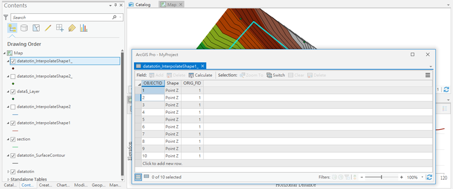
am i working right?
thanks.
- Mark as New
- Bookmark
- Subscribe
- Mute
- Subscribe to RSS Feed
- Permalink
- Report Inappropriate Content
you now have the points... at this point you can proceed with
- the Add Geometry attributes to get the point information to add X, Y and Z values
- and calculate the cumulative distance using the field calculator on a new double field. (or in a secondary program)
If you add a field called SeqDist type double, appropriate precision and scale, set your program to python parser use the below and you can now graph distance versus the Z value
def dist_cumu(shape):
global x0
global y0
global distance
x = shape.firstpoint.X
y = shape.firstpoint.Y
if x0 == 0.0 and y0 == 0.0:
x0 = x
y0 = y
distance += math.sqrt((x - x0)**2 + (y - y0)**2)
x0 = x
y0 = y
return distance
# in the expression box use... python parser of course
# dist_cumu(!Shape!)- Mark as New
- Bookmark
- Subscribe
- Mute
- Subscribe to RSS Feed
- Permalink
- Report Inappropriate Content
hello dan,
But i have failed to do this. do i miss any steps?
i am currently using the arcgis pro (trial version: advanced level with all extensions) before getting the full license.
many thanks again!!
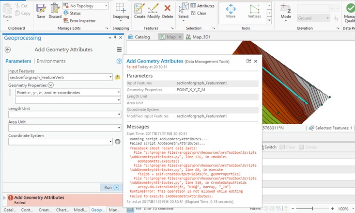
Running script AddGeometryAttributes...
Failed script AddGeometryAttributes...
Traceback (most recent call last): File "c:\program files\arcgis\pro\Resources\ArcToolbox\Scripts\AddGeometryAttributes.py", line 376, in <module> addGeomAtts.execute() File "c:\program files\arcgis\pro\Resources\ArcToolbox\Scripts\AddGeometryAttributes.py", line 60, in execute fields = self.CreateOutputFields(fc, geomProperties) File "c:\program files\arcgis\pro\Resources\ArcToolbox\Scripts\AddGeometryAttributes.py", line 310, in CreateOutputFields arcpy.da.ExtendTable(fc, "OID@", narray, "_ID")RuntimeError: This operation is not allowed while editing
Failed to execute (AddGeometryAttributes).
- Mark as New
- Bookmark
- Subscribe
- Mute
- Subscribe to RSS Feed
- Permalink
- Report Inappropriate Content
looks ok, go old school and add 3 double fields, X, Y and Z.. Use the simple field calculator expressions
!Shape.centroid.X!, !Shape.centroid.Y! and !Shape.centroid.Z!
It is a featureclass I assume and not something else
Also, I trimmed of 3 lines for the function, so add them as in this image to initialize the start values for the distance calculation

- Mark as New
- Bookmark
- Subscribe
- Mute
- Subscribe to RSS Feed
- Permalink
- Report Inappropriate Content
Just what I needed, thanks!