- Home
- :
- All Communities
- :
- Products
- :
- Data Management
- :
- Data Management Questions
- :
- I have a coordinate system projection problem ......
- Subscribe to RSS Feed
- Mark Topic as New
- Mark Topic as Read
- Float this Topic for Current User
- Bookmark
- Subscribe
- Mute
- Printer Friendly Page
I have a coordinate system projection problem ...part 2
- Mark as New
- Bookmark
- Subscribe
- Mute
- Subscribe to RSS Feed
- Permalink
I have a similar issue, wondering if you can help: A new(er) GIS map doc, the data frame coordinate system and all data was captured (GPS) and drawn in NAD_1983_UTM_Zone_15N (matching the ESRI World Imagery). All datasets, aerials, parcels, street centerlines, etc. match, no issues there.
UTM Zone 15N is in meters, I am displaying my units in feet. What I'm not understanding is that, for instance, I have a sewer main that measures (in reality and in my GIS) at ~533'; it displays (in the main's SHAPE_length field) as only 165. I can do the math, knowing that this is given to me in meters, approx. 1/3 of the actual distance.
No matter what I do, I cannot get the map to display and measure everything in feet, representing the reality of field measurements. I've set all my datasets, aerials, parcels, and map document into my preferred coordinate system (NAD_1983 StatePlane Kansas South FIPS 1502) (which is in US Feet), then everything gets even more screwy - a mile section only measures about 1600 map units...
Ideas?
- Mark as New
- Bookmark
- Subscribe
- Mute
- Subscribe to RSS Feed
- Permalink
coincidently, 1 mile is about 1609 meters!
- Mark as New
- Bookmark
- Subscribe
- Mute
- Subscribe to RSS Feed
- Permalink
Yep - right now, I have a calculated field adjacent to my SHAPE_length field that multiplies the drawn length by .3048, giving my necessary foot measurement, obviously a static field until I calculate it again... I'd rather not have a workaround, I'd rather have feet = feet.
- Mark as New
- Bookmark
- Subscribe
- Mute
- Subscribe to RSS Feed
- Permalink
Oops, I meant that I calculated the SHAPE_length field by 3.28084 to get my feet.
- Mark as New
- Bookmark
- Subscribe
- Mute
- Subscribe to RSS Feed
- Permalink
that leaves you projecting the data into a coordinate system whose native units are in feet, which you seem to have identified. Is there a reason you haven't done this?
- Mark as New
- Bookmark
- Subscribe
- Mute
- Subscribe to RSS Feed
- Permalink
But therein lies my issue - When I realized my meters vs feet issue, I did project all my data into my preferred CS, NAD_1983 StatePlane Kansas South FIPS 1502. Everything is in feet - map units, display units but the actual distances remain static in their original state - 165 remains 165, it does not get reprojected to the ~254.2 feet as I had hoped. I'd assumed it would have 'stretched' everything to where it should be on the earth, but it did not... I returned everything to the NAD_1983_UTM_Zone_15N projection when I hit that wall.
- Mark as New
- Bookmark
- Subscribe
- Mute
- Subscribe to RSS Feed
- Permalink
if the distance units are in a table then they would remain the same unless recalculated. If the calculations were based on the geometry field (Shape) and housed in a geodatabase, then Shape_Length would have been recalculated, but not in shapefiles or other attribute fields. And of course, this assumes that the Project tool was used, since Define Projection does nothing good if a coordinate system were already defined
- Mark as New
- Bookmark
- Subscribe
- Mute
- Subscribe to RSS Feed
- Permalink
I'm not sure what happened with the post...
Okay, new day, fresh mind.
I'm not expecting my static and calculated length field to change, only the Shape_length field; I'm also expecting to see the actual measured distance of the sewer main to 'stretch' so that it not only measures its actual field length, it is identified as such in the Shape_length field. I just switched all data and map document to my necessary CS, and same thing - it measures 164.9 map units, and identifies in the Shape_length field as 164.9 map units. It should be 541.1 feet. Both my map units and display units are set to feet.
- Mark as New
- Bookmark
- Subscribe
- Mute
- Subscribe to RSS Feed
- Permalink
What do you mean by "switched"?
You need to really see the actual coordinate system of the data.
Do this in ArcCatalog rather than ArcMap. I think you are getting confused with the ArcMap dataframe, which can have its own coord sys, vs the layer in the map, which can have their own entirely different coord sys.
Right click on the actual data and view the properties.
I suspect that your data is still in a metres based system. To get it to feet, use the Project_management tool.
- Mark as New
- Bookmark
- Subscribe
- Mute
- Subscribe to RSS Feed
- Permalink
Previously, I was changing each dataset/raster to the same coordinate system by going through properties, XY Coordinate System. This was not working, kept everything looking like they were in feet, but still displayed the same meter dimensions.
In the last hour or so, I changed all coordinate systems (using the Project tool in Catalog) to the one I want, which is in feet. I brought all my newly-projected feature classes, etc. into a blank .mxd, and have the same outcome as before.
The same main still measures 165 units, it did not get reprojected to the ~254.2 feet as I needed it to. The aerial, the .tif image in the background, and all feature classes are in the same CS, and verified that the data frame in the .mxd is in the same CS.
CS of sewer dataset/feature classes after Project tool was run: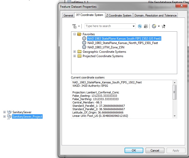
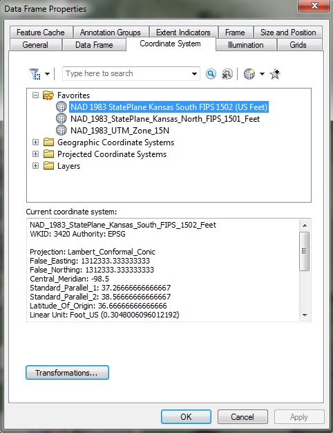
CS in the data frame from new .mxd after bringing in newly-projected feature classes:
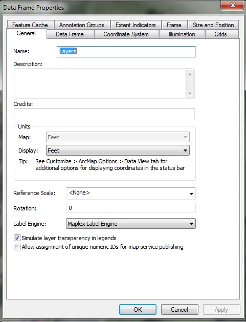
Map units in data frame (not manipulated):