- Home
- :
- All Communities
- :
- Products
- :
- Data Management
- :
- Data Management Questions
- :
- Adding X and Y data points to a shapefile
- Subscribe to RSS Feed
- Mark Topic as New
- Mark Topic as Read
- Float this Topic for Current User
- Bookmark
- Subscribe
- Mute
- Printer Friendly Page
Adding X and Y data points to a shapefile
- Mark as New
- Bookmark
- Subscribe
- Mute
- Subscribe to RSS Feed
- Permalink
Hello Friends, I am new to Arcgis Desktop. I want to show the meteorological stations in my country on map. I have plotted the points but unable to export those points to shapefile. I need your helps on this.
- Mark as New
- Bookmark
- Subscribe
- Mute
- Subscribe to RSS Feed
- Permalink
So you have loaded the data table into ArcMap and created an event theme? Points on the map.
Make sure that the excel table has a proper header line, no funny characters in the column names, and that the data comes in with the correct types (numbers are numbers, text is text etc).
So what happens when you try to export data to a shapefile?
- Mark as New
- Bookmark
- Subscribe
- Mute
- Subscribe to RSS Feed
- Permalink
I have been able to export to shapefile, but I do not know how to put it into the map
- Mark as New
- Bookmark
- Subscribe
- Mute
- Subscribe to RSS Feed
- Permalink
I do not know if I am using the correct term
- Mark as New
- Bookmark
- Subscribe
- Mute
- Subscribe to RSS Feed
- Permalink
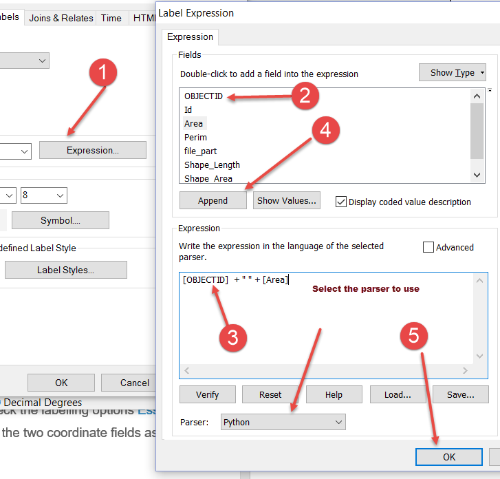
You can add the shapefile to the map using the conventional add data button. If you are wanting to label the points with the coordinates, then you will need to check the labelling options Essential labeling concepts—Help | ArcGIS for Desktop perhaps using the two coordinate fields as the labels
Right-click on the layer, select labeling then set it to show all features in the same way, then select the expression box and formulate your label as in the attached
- Mark as New
- Bookmark
- Subscribe
- Mute
- Subscribe to RSS Feed
- Permalink
Thank you all. I have been able to plot my map. I appreciate your responses
- Mark as New
- Bookmark
- Subscribe
- Mute
- Subscribe to RSS Feed
- Permalink
no problem
- Mark as New
- Bookmark
- Subscribe
- Mute
- Subscribe to RSS Feed
- Permalink
Thank you. One more problem, I need land cover map for my project. I download AVHRR land cover data from glcf.umd.edu. However, the downloaded zip file after extraction was not recognized by Arcgis. The files were saved as GLCF-5173057008600810.b1. Please help how to I open this file. I think it was compressed as binary file.
Thank you