- Home
- :
- All Communities
- :
- Products
- :
- Geoprocessing
- :
- Geoprocessing Questions
- :
- Creating Boundaries/Polygon using attributes.
- Subscribe to RSS Feed
- Mark Topic as New
- Mark Topic as Read
- Float this Topic for Current User
- Bookmark
- Subscribe
- Mute
- Printer Friendly Page
Creating Boundaries/Polygon using attributes.
- Mark as New
- Bookmark
- Subscribe
- Mute
- Subscribe to RSS Feed
- Permalink
HI All
I am looking to create boundaries (complete with no spaces between the original features) based on matching attribute values.
While I can MERGE all the records with the same value, it does not provide me with a complete boundary that encompasses the entire area of all the individual polygons and the spaces between them.
I have also tried other tools such as Dissolve, Feature Envelop and Minimum Bounding Geometry.
The problem I have is that I am looking to create a simple polygon (without overlapping any others).
A Screen Shot of the actual data
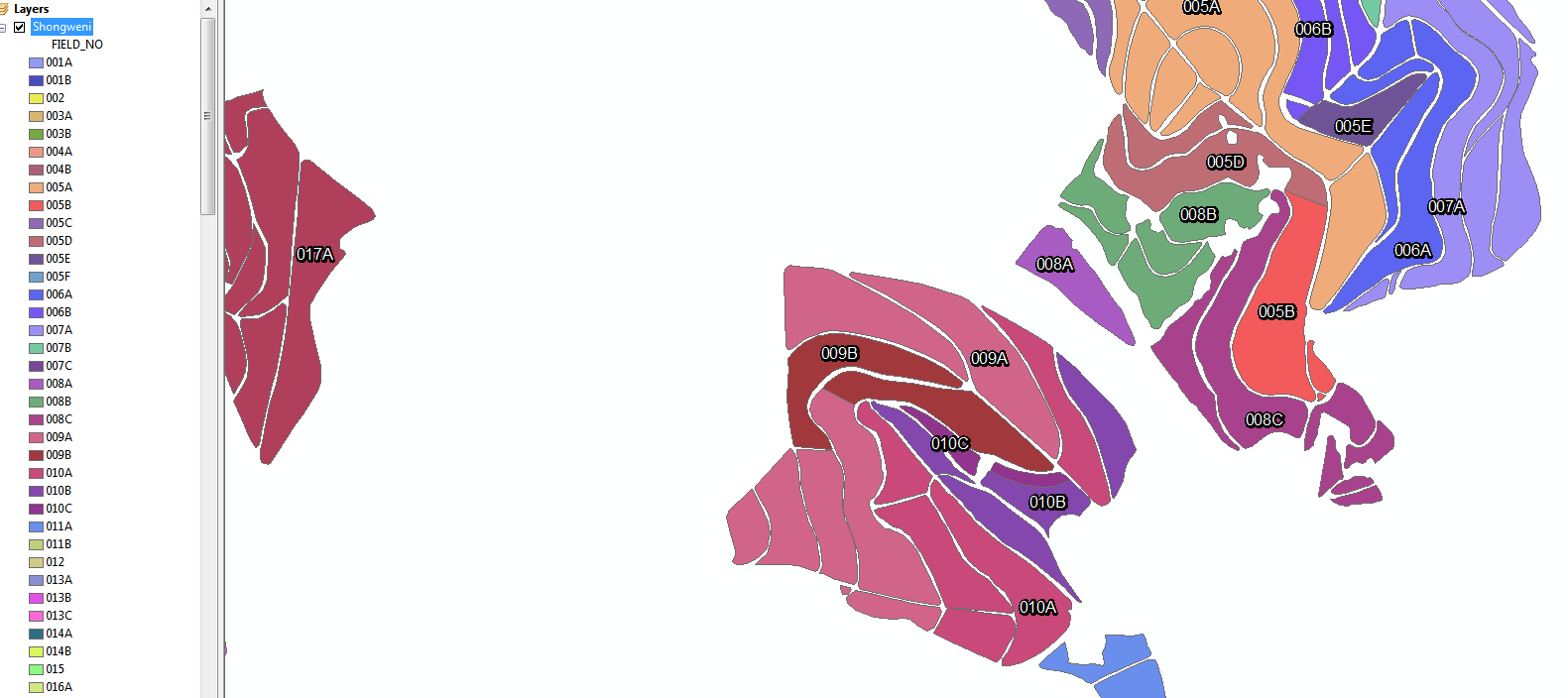
Considering that there are multiple cases where features of the same attribute value does not sit next to one another, can the above be accomplished?
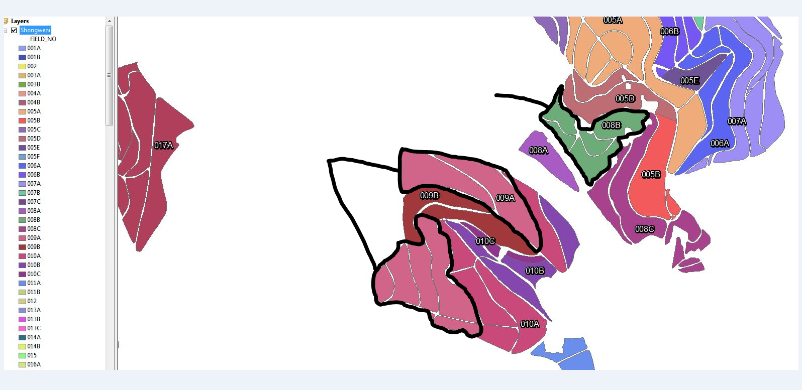
A Screen Shot of how the boundaries should ideally look
Regards,
Zubher.
- Mark as New
- Bookmark
- Subscribe
- Mute
- Subscribe to RSS Feed
- Permalink
If you have an advanced license you could use aggregate polygons
- Mark as New
- Bookmark
- Subscribe
- Mute
- Subscribe to RSS Feed
- Permalink
If you want a little more control you could use feature to polygon on your street center line file I'm assuming the gaps are ROWs you may have to add the lines that don't follow street features such as rivers or district boundary or other. Then you could use a spatial join and then dissolve. It sounds like a lot but goes fast and does a good job
- Mark as New
- Bookmark
- Subscribe
- Mute
- Subscribe to RSS Feed
- Permalink
HI Wes
Thanks for your response.
I did try the aggregate polygons,
The problem with this method is that the space between the fields are not always constant, so it is difficult to get the boundaries I am looking for.
With regards to the 2nd option, the data reflected is actually Cane Farming areas.
The spaces that are reflected are tractor routes that have been manually cut out (over a long period) based on aerial imagery.
Hence we don't have the a centreline to work with.
I could create an overall polygon and then create the "tractor routes" using geo-processing tools, and then go about using a spatial join.
However in this method I would not have control over the "tractor routes" in terms of which fields it dissolves into.
So my outter boundaries could possibly not reflect the accuracy I am looking for, especially in cases where a field is separated by a field of a different value.
- Mark as New
- Bookmark
- Subscribe
- Mute
- Subscribe to RSS Feed
- Permalink
Automation requires strict rules that can be broken down. Expect 20 steps or more for a complex operation like this. You may have to over bound, then trim, then refine, then reexamine, then reprocess, etc. Don't even begin to think this is a one or two tool process.
To begin, of the things you tried, what got you the closest to your end goal for about 80% of your groups or for your least complex cane field? If you want help it is a good idea to show us what a particular tool produced and then point out what you would change if you had the ability to create your own tool. The tool itself is following rules that most of us understand and we can then see where you would have to break those rules and rewrite the tool's rules to get it to do what you want.
I see no rule that accounts for why 009B would ever result in a shape like the one you have drawn. Nothing you have said so far would have lead me to ever draw that. Why does it take any of the white area into its boundary when the others don't? Unless you can explain it to another human you have no hope of getting a computer to follow your rule.
If you have areas with no data or low quality data that you want to "get precise" it is unlikely to happen without creating precise data to work with manually. You probably will only be able to get 80% to 90% of this automated, and the other 10% to 20% will take 100 times as much effort. Aim to fix the 80% to 90% first, then worry about the 10% to 20%. With very complex operations I find that there is always at least 10% that you have to process manually, because they have individualized rules that are both difficult to break down and that would account for such a small set that they are inefficient to automate. In the end you may just end up living with the hard stuff being inaccurate once you can figure out the level of effort it would take to fix it.