- Home
- :
- All Communities
- :
- Products
- :
- Data Management
- :
- Data Management Questions
- :
- Mollweide Projection problem
- Subscribe to RSS Feed
- Mark Topic as New
- Mark Topic as Read
- Float this Topic for Current User
- Bookmark
- Subscribe
- Mute
- Printer Friendly Page
Mollweide Projection problem
- Mark as New
- Bookmark
- Subscribe
- Mute
- Subscribe to RSS Feed
- Permalink
- Report Inappropriate Content
I have shp layers (points, lines, shp). All in WGS84.
I want to make a map, which shows them in Mollweide projection.
What I am doing is:
1 Change coordinate system in layers properties in table of contents
2 Make a new transformation - geocentric with parameters set to 0.
But the map still looks the same. Actually I can't ecen find Mollweide projection in the list in the programme.
Could someone, please, step by step, how to to this?
- Mark as New
- Bookmark
- Subscribe
- Mute
- Subscribe to RSS Feed
- Permalink
- Report Inappropriate Content
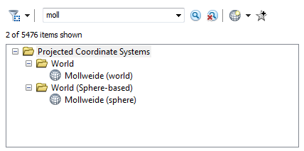
If your layers are each properly referenced (i.e. have the correct spatial reference applied according to their own data), just change the data frame coordinate system to Mollweide to project your data on-the-fly.
Here's where to find it (note how I searched for it):
- Mark as New
- Bookmark
- Subscribe
- Mute
- Subscribe to RSS Feed
- Permalink
- Report Inappropriate Content
Hi,
On a new blank map, you could define a Mollweide coordinate system in the data frame properties, as mentioned by Darren Wiens.
Then you could just add the shp layers to the Table of Contents. They would get projected on-the-fly in the Mollweide Coordinate System.
Think Location