- Home
- :
- All Communities
- :
- Products
- :
- ArcGIS Spatial Analyst
- :
- ArcGIS Spatial Analyst Questions
- :
- Unable to assign Pour Points Shapefile
- Subscribe to RSS Feed
- Mark Topic as New
- Mark Topic as Read
- Float this Topic for Current User
- Bookmark
- Subscribe
- Mute
- Printer Friendly Page
Unable to assign Pour Points Shapefile
- Mark as New
- Bookmark
- Subscribe
- Mute
- Subscribe to RSS Feed
- Permalink
- Report Inappropriate Content
Hello everyone,
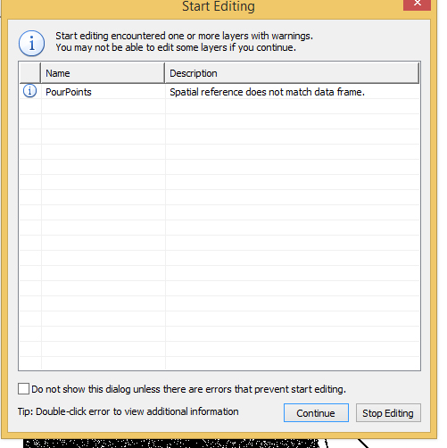
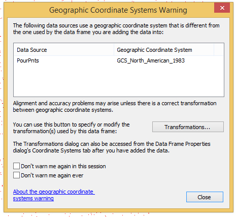
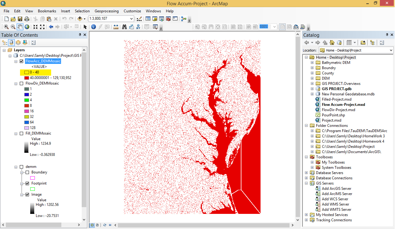
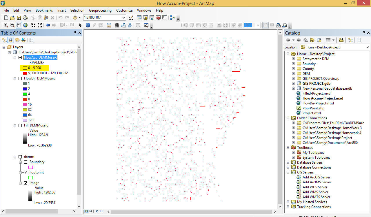
I need to delineate the Chesapeake Bay watershed. For this reason, I took 16 tiles of DEM production(Arcgrid) from USGS database and merge them through Mosaic Database. I ran spatial analyst toolbox (Fill, Flow Direction, Flow Accumulation respectively) with the same spatial references as that of dem datasets (GCS_North_American_1983). Now, when I want to define pour point Shapefile to finalize watershed delineation, It can not snap the cell with the high accumulation. I am sure that Geographic Coordination System is same for my all layers. But when I want to assign relevant cells into the Shapefile of pour-points, it show a warning in which alert for inconsistency between Shapefile and one of the layers (Attachment-1). Also the result of flow accumulation doesn't seem to be satisfactory (Please see Attachment-2,3).
Is there any help you can give me. I don't know where the problem comes from.
Thank you very much
@
- Mark as New
- Bookmark
- Subscribe
- Mute
- Subscribe to RSS Feed
- Permalink
- Report Inappropriate Content
Some things to check right from the start:
1. What is the Data Frame coordinate system? I ask as the Data frame inherits the coordinate system of the first layer you loaded into the mxd, so may have inherited a different coordinate system than what you want.
2. Are you specifying the coordinate system in the Environments settings when running the tools? Doing so will ensure that the coordinate system remains constant.
Chris Donohue, GISP
- Mark as New
- Bookmark
- Subscribe
- Mute
- Subscribe to RSS Feed
- Permalink
- Report Inappropriate Content
Thank you for reply Chris.
All of my initial ArcGrid DEM data comes from USGS map viewer (USGS TNM 2.0 Viewer ) . They are all in the same format of 1 arc-second <date> 1 x 1 degree ArcGrid, with same Spatial Refrence (GCS_North_American_1983) and the same datum and angular unit. And regarding your second question, yes, I changed cell size (Environment>Raster Analysis) in all the steps, to the "same as" input layer.
- Mark as New
- Bookmark
- Subscribe
- Mute
- Subscribe to RSS Feed
- Permalink
- Report Inappropriate Content
How are you getting your pour points and how do you define the snapping distance given that this data is in degrees.
Personally, if I was doing this, I would put the data into a flat projected system first for the analysis.
- Mark as New
- Bookmark
- Subscribe
- Mute
- Subscribe to RSS Feed
- Permalink
- Report Inappropriate Content
Unfortunately, It doesn't allow me to get/snap pour points. The warning in the first image pops out when I first add the new shapefile for pour points. By the way, is there any link in which I can learn about flat projected system that you mentioned?
- Mark as New
- Bookmark
- Subscribe
- Mute
- Subscribe to RSS Feed
- Permalink
- Report Inappropriate Content
Map projections beginning :
ArcGIS Help (10.2, 10.2.1, and 10.2.2)
What do you mean "add pour points". I was asking how are you obtaining your pour points for the purposes of a watershed deliniation. That is all in the help files under hydrology.
Start here :
ArcGIS Help (10.2, 10.2.1, and 10.2.2)
If you are simply adding a point shapefile which you have created in ArcCatalog. Then there is definitely something different about its coordinate system relative to the DEM coord sys. Right click on it and find out what it is defined as.
- Mark as New
- Bookmark
- Subscribe
- Mute
- Subscribe to RSS Feed
- Permalink
- Report Inappropriate Content
Oh, I am trying to add the point manually (through visual inspection, by clicking in the center of the high flow accumulation cells to objectify the outlets). Sorry for misunderstanding. I am sure that all my layers are in the same coordination system. When I add new shape file in ArcCatalog, I just simply change the co-system to what I have for other layers. Is there any other thing should I do?
- Mark as New
- Bookmark
- Subscribe
- Mute
- Subscribe to RSS Feed
- Permalink
- Report Inappropriate Content
As Neil pointed out, your data currently is in a Geographic Coordinate System (GCS). However, for what you want to do, a Projected Coordinate System is the way to go.
Here's how I recommend you proceed:
The first step then is to understand projected coordinate systems. Start with the links that Neil provided.
Then choose an appropriate projected coordinate system - one that works well for spatial extent of your project and minimizes distortion for your analysis.
Then there is the data preparation stage, where all your data is reprojected to the chosen system.
Once all this is done, you can proceed with your analysis. This all may sound like a lot of work, but it is well worth it to get solid results and to avoid issues like you have been encountering.
Chris Donohue, GISP
- Mark as New
- Bookmark
- Subscribe
- Mute
- Subscribe to RSS Feed
- Permalink
- Report Inappropriate Content
Well, once you have decided upon the correct projected coordinate system for your data area, you should really start again.
Just project the actual DEM, then start again generating the filled dem, flow direction etc. Projecting from GCS (or from anything to anything) can actually "close" flow lines where they were open before depending on the DEM resolution and the resampling (in the projection step) involved.
- Mark as New
- Bookmark
- Subscribe
- Mute
- Subscribe to RSS Feed
- Permalink
- Report Inappropriate Content
I found the proper Projection system in the table provided by ESRI help (http://resources.arcgis.com/en/help/main/10.2/003r/pdf/projected_coordinate_systems.pdf), which in this case is (WKID=32618, WGS_1984_UTM_Zone_18N). I merged DEM tiles in mosaic dataset with this projectcion system and ran Fill, Flow-Direction and Flow-Accumulation tools in the same projection system, Each time I set the cell size under Environment>Raster Analyze as same as that of input layer. Unfortunately, I still have the same problem and I am not able to snap the pour points. I think the problem comes from a bay in my area of study and the challenge is how to rout the flow in there.