- Home
- :
- All Communities
- :
- Products
- :
- ArcPad (Retired)
- :
- ArcPad Questions
- :
- ArcPad 10 with NMEA GPS: Auto Populating the Attri...
- Subscribe to RSS Feed
- Mark Topic as New
- Mark Topic as Read
- Float this Topic for Current User
- Bookmark
- Subscribe
- Mute
- Printer Friendly Page
ArcPad 10 with NMEA GPS: Auto Populating the Attribute Table
- Mark as New
- Bookmark
- Subscribe
- Mute
- Subscribe to RSS Feed
- Permalink
We are using ArcPad 10 with a NMEA GPS device. We would like to collect features and populate the attribute table using NMEA values with the following:
Northing Easting PDOP Time
Any ideas?
- Mark as New
- Bookmark
- Subscribe
- Mute
- Subscribe to RSS Feed
- Permalink
Chance,
My code is from an older version of ArcPad, and is a custom .vbs script. There are more parts to this script, and it's calling a few other functions, but this may help. Warning, this is NOT complete code.
To grab the data, I create the point (objNewPoint), and capture the GPS.X, GPS.Y, GPS.Z and the GPS.Properties("PDOP") (and SOG = speed on ground...we're in an airplane), that is I capture the GPS info. For my purposes, I write them to global variables (e.g. PtZ, PtLat, etc) that I pass on to my other script that writes them to the file.
Sub CreatePoint(strLayerName)
'create location object at gps location
Dim objNewPoint,PtZ,PtLat,PtLon,PtX,PtY,PtPDOP,PtSOG
Set objNewPoint = Application.CreateAppObject("point")
objNewPoint.X = GPS.X
objNewPoint.Y = GPS.Y
objNewPoint.Z = GPS.Z
'added to get more accurate data in attribute table
PtZ = objNewPoint.Z
PtLat = GPS.Latitude
PtLon = GPS.Longitude
PtX = objNewPoint.X
PtY = objNewPoint.Y
PtPDOP= GPS.Properties("PDOP")
PtSOG = GPS.Properties("SOG")
'add feature to shapefile and bring up data entry menu
If strLayerName = "animals" Then
If Not Application.Map.AddFeature(objNewPoint) Then
MsgBox "Error adding GPS Point.",vbExclamation,"Error"
objToolButton.Click
Exit Sub
End If
Else
'add feature to shapefile, no menu
If Not Application.Map.AddFeature (objNewPoint,"False") Then
MsgBox "Error adding GPS Point.",vbExclamation,"Error"
Exit Sub
End If
End If
'populate gps and other hidden fields
Call PopulateCommonfields(strLayerName,PtZ,PtLat,PtLon,PtX,PtY,PtPDOP,PtSOG)
'clear point object
Set objNewPoint = Nothing
End Sub
Then, I call another script o write to my shape file (removed most of the script....by the objRS lines are the most important).
sub PopulateCommonFields(strLayerName,PtZ,PtLat,PtLon,PtX,PtY,PtPDOP,PtSOG)
'*** use to populate the common fields for shapefile ***'
Dim objSelLayer, objRS
Set objSelLayer = Application.Map.SelectionLayer
Set objRS = objSelLayer.Records
objRS.Bookmark = Map.SelectionBookmark
'populate common fields
objRS.Fields.Item("Altitude").value = PtZ
objRS.Fields.Item("Latitude").value = PtLat
objRS.Fields.Item("Longitude").value = PtLon
objRS.Fields.Item("Xcoord").value = PtX
objRS.Fields.Item("Ycoord").value = PtY
objRS.Fields.Item("Pdop").value = PtPDOP
objRS.Fields.Item("PlaneMPH").value = PtSOG
objRS.Update
Set objRS = Nothing
End Sub
If you are strictly trying to do this with application builder, I don't have much experience with v8-10....but this may give you a hint on what you need to do.
by the way, my code still runs in 10.x, it was just written in 6.x/7.x.
- Mark as New
- Bookmark
- Subscribe
- Mute
- Subscribe to RSS Feed
- Permalink
Have you looked into using QuickFields? QuickFields allow you to set up values to populate fields in your data automatically - including GPS data. You can build multiple expressions to apply to the one dataset to populate all of the variables you want.
Building your expressions in the Expression Builder - they should look something like this:
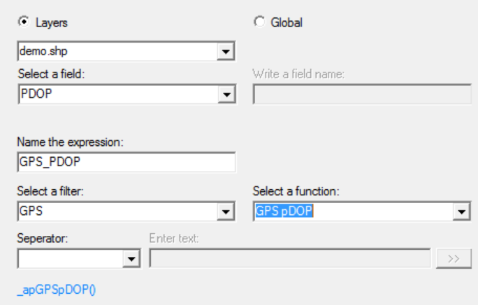
See the ArcPad Help for more information.
HTH,
Hannah
- Mark as New
- Bookmark
- Subscribe
- Mute
- Subscribe to RSS Feed
- Permalink
I know I am a little late in the game here, but more information is always good to have for late comers. I just recently saw a post that gave a link to here Add XYZ to Table . If you read in the summary, it is an applet that you can download and open the code for to get all sorts of data from the GPS. You can chop it up and take what you need. A really good starting point to get the data you may need if you are doing it via Code. Rebecca looks like she has it covered, and Hannah suggested the easier route of QuickFields, but here is just another reference for that info as well as some other for accessing GPS data.