Turn on suggestions
Auto-suggest helps you quickly narrow down your search results by suggesting possible matches as you type.
Cancel
- Home
- :
- All Communities
- :
- Products
- :
- Data Management
- :
- Data Management Questions
- :
- Cropping a lossy image edge for multiple images...
Options
- Subscribe to RSS Feed
- Mark Topic as New
- Mark Topic as Read
- Float this Topic for Current User
- Bookmark
- Subscribe
- Mute
- Printer Friendly Page
Cropping a lossy image edge for multiple images...
Subscribe
1780
1
07-14-2012 10:02 AM
by
Anonymous User
Not applicable
07-14-2012
10:02 AM
- Mark as New
- Bookmark
- Subscribe
- Mute
- Subscribe to RSS Feed
- Permalink
- Report Inappropriate Content
Original User: bmcdevitt
OK, smart ArcGIS imagery people, here is the issue I have.
I have a large number (300+) Landsat images that have already been layer stacked and pansharpened in ERDAS Imagine (saved as Imagine .img files) that I want to use as a raster catalog / raster mosaic in ArcGIS 10.1. Problem is that they all have a black frame around the actual image. See snapshot below:
[ATTACH=CONFIG]16099[/ATTACH]
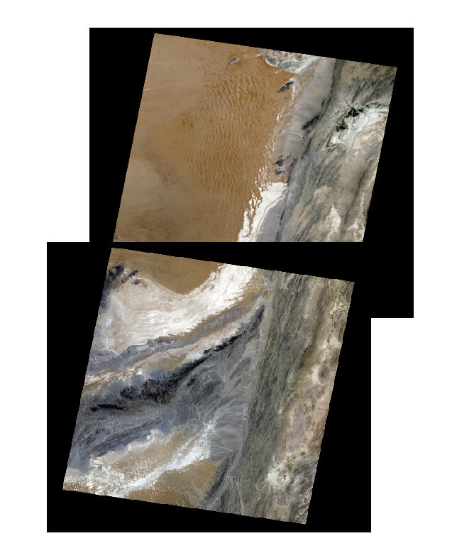
I can set the background to be transparent, but the problem lies in that the edge is lossy (not quite black) and when viewed they have a 'tear line' that shows up very badly in my final product. See snapshots below:
[ATTACH=CONFIG]16100[/ATTACH]
[ATTACH=CONFIG]16101[/ATTACH]
I have been able to remove the edge by using a feature to clip about 10 pixels from the edges of each image and set the NoData so there is no lossy edge, but the feature is geolocked with the image so the feature location needs to be updated with each image. I don't really want to do this for each image if I can help it.
Here is the question: Is there a way to crop this edge off every image (I think the actual image area is the same shape/size for each image, despite location on earth) automatically? I can certainly string some tools together in ModelBuilder to loop through the files, but how could I actually be able to tell Arc how much of the edge of each image to crop off?
Any ideas would be appreciated.
Regards, Bill
OK, smart ArcGIS imagery people, here is the issue I have.
I have a large number (300+) Landsat images that have already been layer stacked and pansharpened in ERDAS Imagine (saved as Imagine .img files) that I want to use as a raster catalog / raster mosaic in ArcGIS 10.1. Problem is that they all have a black frame around the actual image. See snapshot below:
[ATTACH=CONFIG]16099[/ATTACH]
I can set the background to be transparent, but the problem lies in that the edge is lossy (not quite black) and when viewed they have a 'tear line' that shows up very badly in my final product. See snapshots below:
[ATTACH=CONFIG]16100[/ATTACH]
[ATTACH=CONFIG]16101[/ATTACH]
I have been able to remove the edge by using a feature to clip about 10 pixels from the edges of each image and set the NoData so there is no lossy edge, but the feature is geolocked with the image so the feature location needs to be updated with each image. I don't really want to do this for each image if I can help it.
Here is the question: Is there a way to crop this edge off every image (I think the actual image area is the same shape/size for each image, despite location on earth) automatically? I can certainly string some tools together in ModelBuilder to loop through the files, but how could I actually be able to tell Arc how much of the edge of each image to crop off?
Any ideas would be appreciated.
Regards, Bill
1 Reply
by
Anonymous User
Not applicable
07-16-2012
06:59 AM
- Mark as New
- Bookmark
- Subscribe
- Mute
- Subscribe to RSS Feed
- Permalink
- Report Inappropriate Content
Original User: jbswain
Have you tried to rebuild the footprints and utilize the shrink distance? If the area you want to remove is fairly consistent you should be ok by rebuilding the footprint. If you are concerned about the edge, then I would recommend the shrink distance. Also you can try altering the resampling method to nearest neighbor.
Have you tried to rebuild the footprints and utilize the shrink distance? If the area you want to remove is fairly consistent you should be ok by rebuilding the footprint. If you are concerned about the edge, then I would recommend the shrink distance. Also you can try altering the resampling method to nearest neighbor.