- Home
- :
- All Communities
- :
- Developers
- :
- Python
- :
- Python Questions
- :
- Save to PDF script not working
- Subscribe to RSS Feed
- Mark Topic as New
- Mark Topic as Read
- Float this Topic for Current User
- Bookmark
- Subscribe
- Mute
- Printer Friendly Page
Save to PDF script not working
- Mark as New
- Bookmark
- Subscribe
- Mute
- Subscribe to RSS Feed
- Permalink
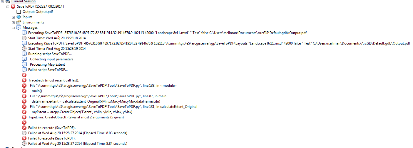
I downloaded the Save to PDF script from the this resources on arcgis.com. I am trying to get it to run in ArcMap but am consistently getting the error shown in this image:
What I want to do is publish the results as a Geoprocessing Service to ArcGIS Server, but can't get it to run correctly in ArcGIS Desktop. Any thoughts as to whats going on here?
Here is the script, which again was downloaded from arcgis.com:
import arcpy
import os


arcpy.env.overwriteOutput = True


def main():


    arcpy.AddMessage("  Collecting input parameters")


    # Get Initial Coordinates
    xMin = arcpy.GetParameterAsText(0)
    if xMin == '#' or not xMin:
        arcpy.AddError("Cannot proceed if xMin is not passed")


    yMin = arcpy.GetParameterAsText(1)
    if yMin == '#' or not yMin:
        arcpy.AddError("Cannot proceed if yMin is not passed")


    xMax = arcpy.GetParameterAsText(2)
    if xMax == '#' or not xMax:
        arcpy.AddError("Cannot proceed if xMax is not passed")


    yMax = arcpy.GetParameterAsText(3)
    if yMax == '#' or not yMax:
        arcpy.AddError("Cannot proceed if yMax is not passed")


    xMin = float(xMin)
    yMin = float(yMin)
    xMax = float(xMax)
    yMax = float(yMax)


    # Get the input spatial reference
    srValIn = arcpy.GetParameterAsText(4)
    if srValIn == '#' or not srValIn:
        arcpy.AddError("Cannot proceed if the Spatial Reference of your extent is not passed")
    srIn = arcpy.CreateObject('SpatialReference')
    srIn.loadFromString(srValIn)


    # Get Layout Folder
    LayoutsFolderPath = arcpy.GetParameterAsText(5)
    if LayoutsFolderPath == '#' or not LayoutsFolderPath:
        arcpy.AddError("Cannot proceed if the Layout Folder is not passed")
        return


    # Get template document
    Layout = arcpy.GetParameterAsText(6)
    if Layout == '#' or not Layout:
        arcpy.AddError(Layout + " does not exist. File not found:" + mxdName)
        return


    mxdName = os.path.join(LayoutsFolderPath, Layout)
    if not (os.path.exists(mxdName)):
        arcpy.AddError(Layout + " does not exist. File not found:" + mxdName)
        return


    mapDoc = arcpy.mapping.MapDocument(mxdName)


    # Get the requested scale
    mapScale = arcpy.GetParameterAsText(7)
    if mapScale == '#' or not mapScale:
        mapScale = 0 # provide a default value if unspecified
    mapScale = float(mapScale)

    # layers only or layers and attributes
    attributesFlag = arcpy.GetParameterAsText(8)
    if attributesFlag.lower() == 'true':
        layers_string = "LAYERS_AND_ATTRIBUTES"
    else:
        layers_string = "LAYERS_ONLY"


    # Get the requested Map Title
    title = arcpy.GetParameterAsText(9)
    if title == '#' or not title:
        title = " " # provide a default value if unspecified


    # Get pdf file path to create
    outputPDFPath = arcpy.GetParameterAsText(10)
    if outputPDFPath == '#' or not outputPDFPath:
        arcpy.AddError("Cannot proceed without specifying an output path for the pdf file")
        return


    # Build the extent in the Layout document
    dataFrame = arcpy.mapping.ListDataFrames(mapDoc)[0]


    arcpy.AddMessage("  Processing Map Extent")
    dataFrame.extent = calculateExtent_Original(xMin,xMax,yMin,yMax,dataFrame,srIn)

    # Set the scale if necessary
    if mapScale > 0:
        arcpy.AddMessage("  Setting scale to: " + str(mapScale))
        dataFrame.scale = mapScale


    # Set the Map title
    if title != " ":
        for elm in arcpy.mapping.ListLayoutElements(mapDoc, "TEXT_ELEMENT"):
            if elm.text == "Map Title":
               elm.text = title


    # Export
    arcpy.AddMessage("  Saving as PDF")
    arcpy.mapping.ExportToPDF(mapDoc,outputPDFPath, layers_attributes=layers_string)


def calculateExtent_Original(xMin,xMax,yMin,yMax,dataFrame,srIn):
    # Make input extent coordinates in the same sr as the data frame
    pntInLL = arcpy.Point()
    pntInLL.X = xMin
    pntInLL.Y = yMin


    pntInUR = arcpy.Point()
    pntInUR.X = xMax
    pntInUR.Y = yMax


    pntGeomInLL = arcpy.PointGeometry(pntInLL,srIn)
    pntGeomInUR = arcpy.PointGeometry(pntInUR,srIn)


    pntGeomList = []
    pntGeomList.append(pntGeomInLL)
    pntGeomList.append(pntGeomInUR)


    arcpy.CopyFeatures_management(pntGeomList, "in_memory/extentPnts")
    rows = arcpy.SearchCursor("in_memory/extentPnts", "", dataFrame.spatialReference)


    rows.reset()
    row = rows.next()
    newPntLL = row.shape.getPart(0)


    row = rows.next()
    newPntUR = row.shape.getPart(0)


  myExtent = arcpy.CreateObject('Extent', xMin, yMin, xMax, yMax)
  #arcpy.AddMessage("New extent: %s %s %s %s" % (myExtent.XMin, myExtent.YMin, myExtent.XMax, myExtent.YMax))


    return myExtent


if __name__ == "__main__":
    main()
- Mark as New
- Bookmark
- Subscribe
- Mute
- Subscribe to RSS Feed
- Permalink
A note on the CreateObject help page suggests using the Extent class directly. Try changing line 160 from:
# myExtent = arcpy.CreateObject('Extent', xMin, yMin, xMax, yMax)
myExtent = arcpy.Extent(xMin, yMin, xMax, yMax)
- Mark as New
- Bookmark
- Subscribe
- Mute
- Subscribe to RSS Feed
- Permalink
That was it! Thank you so much for your help!