Turn on suggestions
Auto-suggest helps you quickly narrow down your search results by suggesting possible matches as you type.
Cancel
- Home
- :
- All Communities
- :
- Products
- :
- Geoprocessing
- :
- Geoprocessing Questions
- :
- Con function on Zonal Geometry Raster
Options
- Subscribe to RSS Feed
- Mark Topic as New
- Mark Topic as Read
- Float this Topic for Current User
- Bookmark
- Subscribe
- Mute
- Printer Friendly Page
Con function on Zonal Geometry Raster
Subscribe
3101
1
09-28-2013 10:40 AM
09-28-2013
10:40 AM
- Mark as New
- Bookmark
- Subscribe
- Mute
- Subscribe to RSS Feed
- Permalink
I have a Zonal Geometry output raster that I would like to perform the Con tool/function on. When I try I get this error:
Executing (Con): Con "C:\Users\Agent\Desktop\FOR2286\Spatial Analysis and Modeling\Reclassify\Data\Woodlot II\UNB Woodlot.mdb\ZonalGe_Regi1" 1 "C:\Users\Agent\Desktop\FOR2286\Spatial Analysis and Modeling\Reclassify\Data\Woodlot II\UNB Woodlot.mdb\SQHabitat" # ""Value" >=50000"
Start Time: Sat Sep 28 14:28:24 2013
ERROR 999999: Error executing function.
(DAO.Recordset) No current record.
ERROR 010416: Error in setting raster table filter for C:\Users\Agent\Desktop\FOR2286\Spatial Analysis and Modeling\Reclassify\Data\Woodlot II\UNB Woodlot.mdb\ZonalGe_Regi1.
ERROR 010213: Error in reading raster Layer_1.
ERROR 010325: Run-time error - ***.
ERROR 010067: Error in executing grid expression.
Failed to execute (Con).
Failed at Sat Sep 28 14:28:24 2013 (Elapsed Time: 0.00 seconds)
I am working in ArcMap 10.1, windows 7 64 bit pro. The Zonal Geometry raster is 32 bit floating. It seems like any Con function/tool cannot read the values in the zonal raster.
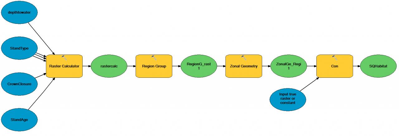
The workflow is originally from a simple model I made: Raster calculator output raster into Region Group, Region Group raster into Zonal Geometry, Zonal Geometry raster output into Con tool or raster calculator for areas >=50000 meters square and I get this error.
I have had the zonal raster in personal and file geodatabases, on its own in a folder, I've converted the raster to 16/8 bit, taken out spaces in paths and had the same error.
In the above error I've typed the expression as the sql builder does not let me choose/see a "value" field.
Any suggestions?
Regards,
PCP
Executing (Con): Con "C:\Users\Agent\Desktop\FOR2286\Spatial Analysis and Modeling\Reclassify\Data\Woodlot II\UNB Woodlot.mdb\ZonalGe_Regi1" 1 "C:\Users\Agent\Desktop\FOR2286\Spatial Analysis and Modeling\Reclassify\Data\Woodlot II\UNB Woodlot.mdb\SQHabitat" # ""Value" >=50000"
Start Time: Sat Sep 28 14:28:24 2013
ERROR 999999: Error executing function.
(DAO.Recordset) No current record.
ERROR 010416: Error in setting raster table filter for C:\Users\Agent\Desktop\FOR2286\Spatial Analysis and Modeling\Reclassify\Data\Woodlot II\UNB Woodlot.mdb\ZonalGe_Regi1.
ERROR 010213: Error in reading raster Layer_1.
ERROR 010325: Run-time error - ***.
ERROR 010067: Error in executing grid expression.
Failed to execute (Con).
Failed at Sat Sep 28 14:28:24 2013 (Elapsed Time: 0.00 seconds)
I am working in ArcMap 10.1, windows 7 64 bit pro. The Zonal Geometry raster is 32 bit floating. It seems like any Con function/tool cannot read the values in the zonal raster.
The workflow is originally from a simple model I made: Raster calculator output raster into Region Group, Region Group raster into Zonal Geometry, Zonal Geometry raster output into Con tool or raster calculator for areas >=50000 meters square and I get this error.
I have had the zonal raster in personal and file geodatabases, on its own in a folder, I've converted the raster to 16/8 bit, taken out spaces in paths and had the same error.
In the above error I've typed the expression as the sql builder does not let me choose/see a "value" field.
Any suggestions?
Regards,
PCP
1 Reply
09-30-2013
01:21 PM
- Mark as New
- Bookmark
- Subscribe
- Mute
- Subscribe to RSS Feed
- Permalink
Some suggestions:
1. Make sure the zone raster is interger-based and has a raster attribute table built for it
2. Use FGDB or GRID format rasters (don't use a personal geodatabase, unless there is a good reason)
1. Make sure the zone raster is interger-based and has a raster attribute table built for it
2. Use FGDB or GRID format rasters (don't use a personal geodatabase, unless there is a good reason)