Turn on suggestions
Auto-suggest helps you quickly narrow down your search results by suggesting possible matches as you type.
Cancel
- Home
- :
- All Communities
- :
- Products
- :
- ArcGIS Data Reviewer
- :
- ArcGIS Data Reviewer Questions
- :
- Create Polygon Grid error for bounding box
Options
- Subscribe to RSS Feed
- Mark Topic as New
- Mark Topic as Read
- Float this Topic for Current User
- Bookmark
- Subscribe
- Mute
- Printer Friendly Page
Create Polygon Grid error for bounding box
Subscribe
3485
3
08-02-2013 01:01 PM
08-02-2013
01:01 PM
- Mark as New
- Bookmark
- Subscribe
- Mute
- Subscribe to RSS Feed
- Permalink
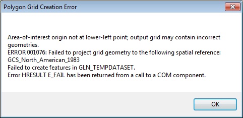
I'm trying to create a polygon grid using a boundary box for visual data review. I've tried to create the grid feature class in both an ArcSDE geodatabsae and a file geodatabase. Both locations result in the same error - 001076; failed to project grid geometry to spatial reference: GCS_North_American_1983. See full error message: [ATTACH=CONFIG]26437[/ATTACH]
The Data Reviewer workspace was setup in NAD_1983_UTM_Zone_11N projection system. The only feature class in my mxd is also in NAD_1983_UTM_Zone_11N. Why am I getting an error message about GCS coordinate system?
During setup of the Data Reviewer workspace, I was unable to grant edit permission to the REVTABLEGUIPROPERTIES table, getting an error 9999999 - failed to execute. Also I was unable to grant select permission to the RevAdminCustomFields and RevAdminDescriptions tables, getting an error 9999999 - failed to execute.
Could this be a permission issue?
ArcSDE 10.0 SP3
ArcGIS Desktop 10.0 SP4
3 Replies
08-02-2013
02:57 PM
- Mark as New
- Bookmark
- Subscribe
- Mute
- Subscribe to RSS Feed
- Permalink
Hello,
What service pack do you have installed for Data Reviewer? There was a fix in Data Reviewer's 10.0 SP1 that addressed an issue with the Polygon Grid Wizard, which might be related to what you are experiencing.
Since you have core's SP4 installed, you would need DR's SP4. Note that the latest Data Reviewer service pack and patch is SP5 Patch 2, which requires Core's SP5.
08-02-2013
03:49 PM
- Mark as New
- Bookmark
- Subscribe
- Mute
- Subscribe to RSS Feed
- Permalink
I have Service Pack 1 on the Data Reviewer. Wow, I didn't know there was a SP4. I'll install it and report how it goes.
Stephanie
Stephanie
08-02-2013
04:28 PM
- Mark as New
- Bookmark
- Subscribe
- Mute
- Subscribe to RSS Feed
- Permalink
I went ahead and upgraded ArcGIS Desktop to SP 5, then upgraded Data Reviewer for SP 5 Patch 2. The create polygon grid works perfectly. Thank you!!!